Fjell
| Fjell kommune | |||
|---|---|---|---|
| Municipality | |||
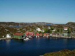 View of the village of Misje | |||
| |||
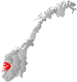
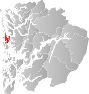 Fjell within Hordaland | |||
| Coordinates: 60°20′50″N 05°02′49″E / 60.34722°N 5.04694°ECoordinates: 60°20′50″N 05°02′49″E / 60.34722°N 5.04694°E | |||
| Country | Norway | ||
| County | Hordaland | ||
| District | Midhordland | ||
| Administrative centre | Straume | ||
| Government | |||
| • Mayor (2015) | Marianne S. Bjorøy (Ap) | ||
| Area | |||
| • Total | 148.17 km2 (57.21 sq mi) | ||
| • Land | 141.20 km2 (54.52 sq mi) | ||
| • Water | 6.97 km2 (2.69 sq mi) | ||
| Area rank | #355 in Norway | ||
| Population (2017) | |||
| • Total | 25,204 | ||
| • Rank | #43 in Norway | ||
| • Density | 178.5/km2 (462/sq mi) | ||
| • Change (10 years) | 21.2% | ||
| Demonym(s) |
Fjellsoknar Fjellsokning[1] | ||
| Time zone | UTC+01:00 (CET) | ||
| • Summer (DST) | UTC+02:00 (CEST) | ||
| ISO 3166 code | NO-1246 | ||
| Official language form | Nynorsk | ||
| Website |
www | ||
Fjell is a municipality in Hordaland county, Norway. It is part of the traditional district of Midhordland. The municipality consists of several islands west of the city of Bergen, the major ones being Litlesotra, the northern part of Store Sotra, Bildøy, Bjorøy, Misje, and Turøy. The administrative centre of Fjell is the village of Straume. Some of the villages in Fjell include Ågotnes, Fjell, Foldnes, Knappskog, Knarrevik, Kolltveit, Landro, and Sekkingstad.
Due to the opening the Sotra Bridge to the mainland in 1971 and its proximity to the city of Bergen, the population has grown from less than 7,000 to over 25,000 as of 2017. The result is major traffic jams over the bridge every day. The highway that leads to Bergen has reduced the traveling time to only fifteen minutes from the municipal centre at Straume on Litlesotra to the center of Bergen.
The 148-square-kilometre (57 sq mi) municipality is the 355th largest by area out of the 422 municipalities in Norway. Fjell is the 43rd most populous municipality in Norway with a population of 25,204. The municipality's population density is 178.5 inhabitants per square kilometre (462/sq mi) and its population has increased by 21.2% over the last decade.[2]
General information


The parish of Fjæld was established as a municipality on 1 January 1838 (see formannskapsdistrikt). On 1 January 1964, the islands of Misje and Turøyna (population: 404) were transferred from the municipality of Herdla to the municipality of Fjell.[3]
On 1 January 2020, the three neighboring municipalities of Fjell, Sund, and Øygarden will be merging into one large island municipality called Øygarden.[4]
Name
The municipality (originally the parish) is named after the old Fjell farm (Old Norse: Fjall), where the first Fjell Church was built. The name is identical with the modern Norwegian word fjell which means "mountain". The oldest form of the name was Undir Fjalli which means "under/below the mountain". Before 1918, the name was written Fjæld or Fjeld.[5]
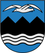
Coat of arms
The coat-of-arms was granted on 27 April 1957. The arms are black and gray with a blue background. They show the geography in the municipality, specifically the sea (shown with gray wavy lines) and the steep mountains (shown with three black triangular shapes). The gray seagull shown above the mountains is a typical bird in the area.[6]
Churches
The Church of Norway has one parish (sokn) within the municipality of Fjell. It is part of the Vesthordland deanery in the Diocese of Bjørgvin.
| Parish (Sokn) | Church Name | Location of the Church | Year Built |
|---|---|---|---|
| Fjell | Fjell Church | Fjell | 1874 |
| Foldnes Church | Foldnes | 2001 | |
| Landro Church | Landro | 1977 |
Geography
Fjell is an island municipality located entirely on islands off the coast of the mainland Bergen Peninsula. It covers many islands in a large archipelago that stretches from Sund in the south to Fedje in the north. The largest island in Fjell is Sotra, although only the northern half of the island is part of Fjell. The second-largest island is Litlesotra, where the largest village area in Fjell is located (the village of Straume). The small island of Bildøyna lies between those two islands. The small island of Geitung lies north of Bildøyna and the small island of Bjorøy lies to the south. Bjorøy is not connected to Fjell by road, but there is the undersea Bjorøy Tunnel that connects it to the city of Bergen. On the western side of Sotra, the smaller islands of Algrøyna, Lokøyna, and Syltøyna are located. On the north end of Sotra lies the small islands of Misje and Turøyna.[7]
History
| Historical population | ||
|---|---|---|
| Year | Pop. | ±% |
| 1951 | 5,172 | — |
| 1960 | 5,453 | +5.4% |
| 1970 | 6,798 | +24.7% |
| 1980 | 10,177 | +49.7% |
| 1990 | 14,735 | +44.8% |
| 2000 | 18,178 | +23.4% |
| 2010 | 21,909 | +20.5% |
| 2017 | 25,204 | +15.0% |
| Source: Statistics Norway. | ||
Fjell is the location of Fjell Fortress, a World War II German mountaintop fortification designed to command all water approaches to the port of Bergen.[7]
Government
All municipalities in Norway, including Fjell, are responsible for primary education (through 10th grade), outpatient health services, senior citizen services, unemployment and other social services, zoning, economic development, and municipal roads. The municipality is governed by a municipal council of elected representatives, which in turn elect a mayor.
Municipal council
The municipal council (Kommunestyre) of Fjell is made up of 35 representatives that are elected to four year terms. Currently, the party breakdown is as follows:[8]
| Party Name | Name in Norwegian | Number of representatives | |
|---|---|---|---|
| Labour Party | Arbeiderpartiet | 10 | |
| Progress Party | Framstegspartiet | 4 | |
| Conservative Party | Høgre | 8 | |
| Christian Democratic Party | Kristelig Folkeparti | 4 | |
| Green Party | Miljøpartiet Dei Grøne | 1 | |
| Centre Party | Senterpartiet | 1 | |
| Socialist Left Party | Sosialistisk Venstreparti | 1 | |
| Liberal Party | Venstre | 2 | |
| Local Lists | Lokale lister | 4 | |
| Total number of members: | 35 | ||
References
- ↑ "Navn på steder og personer: Innbyggjarnamn" (in Norwegian). Språkrådet. Retrieved 2015-12-01.
- ↑ Statistisk sentralbyrå (2017). "Table: 06913: Population 1 January and population changes during the calendar year (M)" (in Norwegian). Retrieved 2017-10-28.
- ↑ Jukvam, Dag (1999). "Historisk oversikt over endringer i kommune- og fylkesinndelingen" (PDF) (in Norwegian). Statistisk sentralbyrå.
- ↑ "Vår nye kommune" (in Norwegian). Retrieved 2017-10-28.
- ↑ Rygh, Oluf (1910). Norske gaardnavne: Søndre Bergenhus amt (in Norwegian) (11 ed.). Kristiania, Norge: W. C. Fabritius & sønners bogtrikkeri. p. 268.
- ↑ "Civic heraldry of Norway - Norske Kommunevåpen". Heraldry of the World. Retrieved 2014-12-09.
- 1 2 Store norske leksikon. "Fjell – kommune" (in Norwegian). Retrieved 2014-12-09.
- ↑ "Table: 04813: Members of the local councils, by party/electoral list at the Municipal Council election (M)" (in Norwegian). Statistics Norway. 2015.
External links
| Wikimedia Commons has media related to Fjell. |
- Municipality web site (in Norwegian)
- Municipal fact sheet from Statistics Norway (in Norwegian)