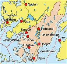
Os, Hordaland
| Os kommune | |||
|---|---|---|---|
| Municipality | |||
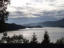
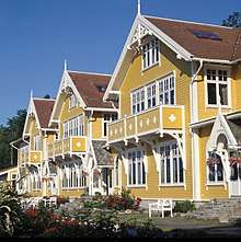
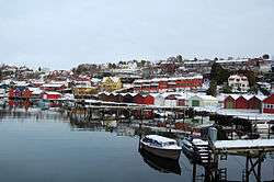 View of Osøyro | |||
| |||
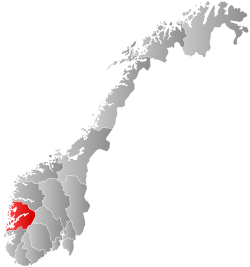
 Os within Hordaland | |||
| Coordinates: 60°13′37″N 05°28′33″E / 60.22694°N 5.47583°ECoordinates: 60°13′37″N 05°28′33″E / 60.22694°N 5.47583°E | |||
| Country | Norway | ||
| County | Hordaland | ||
| District | Midhordland | ||
| Administrative centre | Osøyro | ||
| Government | |||
| • Mayor (2016) | Marie Lunde Bruarøy (H) | ||
| Area | |||
| • Total | 139.57 km2 (53.89 sq mi) | ||
| • Land | 133.48 km2 (51.54 sq mi) | ||
| • Water | 6.09 km2 (2.35 sq mi) | ||
| Area rank | #360 in Norway | ||
| Population (2017) | |||
| • Total | 20,152 | ||
| • Rank | #57 in Norway | ||
| • Density | 151.0/km2 (391/sq mi) | ||
| • Change (10 years) | 29.2% | ||
| Demonym(s) | Osing[1] | ||
| Time zone | UTC+01:00 (CET) | ||
| • Summer (DST) | UTC+02:00 (CEST) | ||
| ISO 3166 code | NO-1243 | ||
| Official language form | Nynorsk | ||
| Website |
www | ||
Os is a city and municipality in Hordaland county, Norway. It is located in the Midhordland region, just south of Norway's second-largest city, Bergen. Due to its proximity to Bergen, Os is experiencing strong population growth.[2] The administrative centre (and commercial centre) of Os is the village of Osøyro. It is the largest settlement in the municipality, with over 60% of the municipal residents living here. Other large villages in Os include Hagavik, Halhjem, Søfteland, Søre Øyane, and Søvik.
The 140-square-kilometre (54 sq mi) municipality is the 360th largest by area out of the 422 municipalities in Norway. Os is the 57th most populous municipality in Norway with a population of 20,152. The municipality's population density is 151 inhabitants per square kilometre (390/sq mi) and its population has increased by 29.2% over the last decade.[3]
History
The parish of Os was established as a formannskapsdistrikt, the predecessor of today's municipalities, on 1 January 1838. It originally encompassed all of the land surrounding the Fusafjorden. In 1856, the eastern district of Os (across the fjord) was separated to form the new, separate municipality of Fusa. This left Os with 3,750 residents.[4]
In 1900, "Askviknes Barnehjem" (near Hagavik) opened; it housed children of romani/tater; in the beginning the children's stay was something their families applied for; later children were introduced to the facility without consent of their families.[5]
On 1 January 1907, the northern part of the municipality was separated to form the new municipality of Samnanger. This left Os with 3,188 residents. During the 1960s, there were many municipal mergers across Norway due to the work of the Schei Committee. On 1 January 1964, the Bogstrand area of Fusa (population: 28) was transferred to Os. This was the only part of Fusa on the west side of the fjord.[4]
During World War II, the Ulven concentration camp was used by the occupying Nazi German Army. It was located just northwest of Osøyro.
On 1 January 2020, the neighboring municipalities of Os and Fusa will be merged once again, but this time using the name Bjørnafjorden.[6]
Name
The municipality is named after the old Os farm, where the first Os Church was built. The name is identical with the Old Norse word "óss" which means "mouth of a river"; referring to the Oselva River.[7]
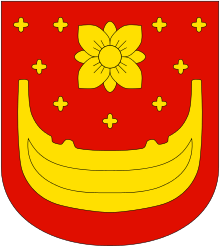
Coat-of-Arms
The coat-of-arms is relatively modern, having been adopted in 1949 after a local competition. The arms are gold with a red background. The lower part of it shows one Oselvar, a boat design traditionally associated with the area. There is a small flower design above the boat.[8] [9]
Churches
The Church of Norway has one parish (sokn) within the municipality of Os. It is part of the Fana deanery in the Diocese of Bjørgvin.
| Parish (Sokn) | Church Name | Location of the Church | Year Built |
|---|---|---|---|
| Os | Os Church | Osøyro | 1870 |
| Nore Neset Church | Hagavik | 2000 |
Government
All municipalities in Norway, including Os, are responsible for primary education (through 10th grade), outpatient health services, senior citizen services, unemployment and other social services, zoning, economic development, and municipal roads. The municipality is governed by a municipal council of elected representatives, which in turn elect a mayor.
Municipal council
The municipal council (Kommunestyre) of Os is made up of 35 representatives that are elected to four year terms. Currently, the party breakdown is as follows:[10]
| Party Name | Name in Norwegian | Number of representatives | |
|---|---|---|---|
| Labour Party | Arbeiderpartiet | 7 | |
| Progress Party | Framstegspartiet | 14 | |
| Conservative Party | Høgre | 4 | |
| Christian Democratic Party | Kristelig Folkeparti | 2 | |
| Green Party | Miljøpartiet Dei Grøne | 2 | |
| Centre Party | Senterpartiet | 2 | |
| Liberal Party | Venstre | 2 | |
| Local Lists | Lokale lister | 2 | |
| Total number of members: | 35 | ||
Mayor
In 1999, the Progress Party won the local election, and Terje Søviknes became the first Progressive Party politician to hold the position of mayor in Os. He was re-elected in 2003, 2007, and 2011.
Before World War II, the municipality was led by Mayor Nils Tveit from 1916 to 1940. He also held the position briefly after the German occupation of Norway had ended.
Geography
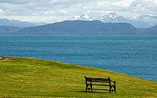
The municipality of Os lies on the southwestern part of the Bergen Peninsula, south of the municipality of Bergen and southeast of the municipality of Samnanger. The Fusafjorden lies to the east, the Bjørnafjorden to the south, and the Lysefjorden lies to the west. The municipality of Fusa lies to the east (across the Fusafjorden), the municipality of Tysnes lies to the south (across the Bjørnafjorden), and the municipality of Austevoll lies to the west (across the Lysefjorden).
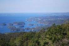
The southwestern part of Os includes many small islands including Skorpo, Strøno, and Innerøya. The village area of Søre Øyane lies on several small islands off the mainland shore.
The municipality is somewhat mountainous, especially in the northeastern part of the municipality. The mountain Sveningen is a tripoint boundary, marking the boundary point where the municipalities of Bergen, Os, and Samnanger meet. It is located in extreme northeastern Os. The mountains of Mosnuken and Lyshornet are both located in Os.
Culture
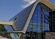
The Oseana Art and Cultural Centre is located in Os. It hosts art and music events year-round. The building is fairly new and in 2011, it won the "Building of the Year Award" (Årets Bygg) for Norway.[11]
Industry
Os has a tradition of small boat building since the early 1800s. The Oselvar is the traditional boat of Os. This small wooden boat was named after its major important building site during the 18th century, at the mouth of the Oselva River. These boats have traditionally been used for everyday work and for traveling to church. These boats were designed as either sailboats or rowboats. They still build these boats the traditional way in Os, and tourists are able to visit and watch them work.[12]
The Oselvar is now the official boat of Norway. With its traditions, the boat has become a symbol of the nation. The boat is shown on the coat-of-arms of Os.
Hagavik, a village in Os municipality, also has a modern boat building company, Askeladden Boats AS. Askeladden is Norway's largest manufacturer of leisure boats.
Transportation
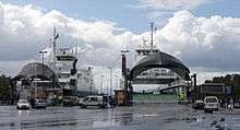
The European route E39 highway runs through Os from the city of Bergen (to the north) to the ferry quay at Halhjem, on the shore of the Bjørnafjorden. The quay has two different regularly-scheduled ferry routes that stop here to cross the Bjørnafjorden. There is a ferry from Halhjem to Våge on the island of Tysnesøya in Tysnes municipality, to the southeast. There is also a ferry (that is part of the E39 highway) from Halhjem to Sandvika, just north of the village of Fitjar in Fitjar municipality, to the south.
The Norwegian government is planning to build a bridge or tunnel crossing to provide road access across the Bjørnafjorden. When completed, the northern terminus will be in Os.[13]
Demographics
| Historical population | ||
|---|---|---|
| Year | Pop. | ±% |
| 1951 | 5,580 | — |
| 1961 | 6,742 | +20.8% |
| 1971 | 8,162 | +21.1% |
| 1981 | 10,874 | +33.2% |
| 1991 | 12,781 | +17.5% |
| 2001 | 13,972 | +9.3% |
| 2011 | 17,210 | +23.2% |
| 2017 | 20,152 | +17.1% |
| Source: Statistics Norway.[14][15] | ||
As of 1 January 2014, Os has a population of 18,678 which gives it a population density is 139.9 inhabitants per square kilometre (362/sq mi), compared to a county average of about 30 people per square kilometre and a national average of about 15 people per square kilometre. About 80% of the population of Os lived in urban settlements. About 1.9% of the population were registered as unemployed; the county and national average is 2.6%. 26% of the workforce were employed in public administration. 2% were employed in the primary sector of economic activity, 28.2 in the secondary sector, and 69.3% in the tertiary sector.[16] In the period from 29 October to 4 November 2001, 45.7% of the workforce of Os commuted out of the municipality, mainly to Bergen. In the same period, Os received a daily average of 753 commuters from other municipalities, 15.8% of those employed in Os.[17] In 2006, Os had a daily out-commuting of 3,001 people.[16]
Notable residents
The famous violinist Ole Bull built his summerhouse in Os, on an island named Lysøen. The special building was inspired by his travels, especially his travels to the Middle East. Lysøen was originally owned by Lyse Abbey, the ruins of which still stand and are frequently visited.
The singer-songwriter Aurora Aksnes, although born in Stavanger, grew up in Os.
References
- ↑ "Navn på steder og personer: Innbyggjarnamn" (in Norwegian). Språkrådet. Retrieved 2015-12-01.
- ↑ Os kommune i Hordaland (Os municipality)
- ↑ Statistisk sentralbyrå (2017). "Table: 06913: Population 1 January and population changes during the calendar year (M)" (in Norwegian). Retrieved 2018-01-05.
- 1 2 Jukvam, Dag (1999). "Historisk oversikt over endringer i kommune- og fylkesinndelingen" (PDF) (in Norwegian). Statistisk sentralbyrå.
- ↑ Marianne Herfindal Johannessen (2015-08-01). "'De hjemløse smaa'". Bergens Tidende. pp. 54–5.
- ↑ "Bjørnafjorden kommune" (in Norwegian). Retrieved 2017-10-26.
- ↑ Rygh, Oluf (1919). Norske gaardnavne: Nordre Bergenhus amt (in Norwegian) (12 ed.). Kristiania, Norge: W. C. Fabritius & sønners bogtrikkeri. p. 206.
- ↑ "Civic heraldry of Norway - Norske Kommunevåpen". Heraldry of the World. Retrieved 2014-08-09.
- ↑ "Oselvar Boats". Archived from the original on 2008-10-03.
- ↑ "Table: 04813: Members of the local councils, by party/electoral list at the Municipal Council election (M)" (in Norwegian). Statistics Norway. 2015.
- ↑ Oseana i pengetrøbbel
- ↑ Oselvaren (Os kommune)
- ↑ Gir ikkje opp brumotstanden
- ↑ Projected population - Statistics Norway
- ↑ Per 1 January 1964, 28 persons were transferred from 1241 Fusa to 1243 Os.
- 1 2 "Figures on Os Municipality" (in Norwegian). Statistics Norway. 2008. Archived from the original on 2008-10-05. Retrieved 2008-05-31.
- ↑ "Commuting. Population and housing Census 2001" (in Norwegian). Statistics Norway. 2002. Retrieved 2008-05-31.
External links
| Wikimedia Commons has media related to Os, Hordaland. |
| Wikivoyage has a travel guide for Os (Hordaland). |
- Municipal fact sheet from Statistics Norway (in Norwegian)
- Askeladden Boats AS official website
- Oselvar Boat Yard