Fitjar
| Fitjar kommune | |||
|---|---|---|---|
| Municipality | |||
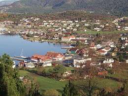 View of the village of Fitjar | |||
| |||
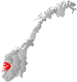
 Fitjar within Hordaland | |||
| Coordinates: 59°55′08″N 05°22′17″E / 59.91889°N 5.37139°ECoordinates: 59°55′08″N 05°22′17″E / 59.91889°N 5.37139°E | |||
| Country | Norway | ||
| County | Hordaland | ||
| District | Sunnhordland | ||
| Administrative centre | Fitjar | ||
| Government | |||
| • Mayor (2011) | Wenche Tislevoll (H) | ||
| Area | |||
| • Total | 142.43 km2 (54.99 sq mi) | ||
| • Land | 134.45 km2 (51.91 sq mi) | ||
| • Water | 7.98 km2 (3.08 sq mi) | ||
| Area rank | #357 in Norway | ||
| Population (2017) | |||
| • Total | 3,189 | ||
| • Rank | #258 in Norway | ||
| • Density | 23.7/km2 (61/sq mi) | ||
| • Change (10 years) | 10.1% | ||
| Demonym(s) | Fitjabu[1] | ||
| Time zone | UTC+01:00 (CET) | ||
| • Summer (DST) | UTC+02:00 (CEST) | ||
| ISO 3166 code | NO-1222 | ||
| Official language form | Nynorsk | ||
| Website |
www | ||

Fitjar (Norwegian pronunciation: [²fitːjɑr] (![]()
The 142-square-kilometre (55 sq mi) municipality is the 357th largest by area out of the 422 municipalities in Norway. Fitjar is the 258th most populous municipality in Norway with a population of 3,189. The municipality's population density is 23.7 inhabitants per square kilometre (61/sq mi) and its population has increased by 10.1% over the last decade.[3]
General information


The parish of Fitje was established as a municipality on 1 January 1863 when it was separated from the large municipality of Stord. Initially, the population of Fitje was 2,313. On 1 January 1868, a small area in the municipality of Finnaas (population: 10) was transferred to Fitje. In 1900, the name was changed to Fitjar. The original municipality included all of the land surrounding the Selbjørnsfjorden. On 1 January 1964, the area of Fitjar located north of the Selbjørnsfjorden on the islands of Huftarøy and Selbjørn (population: 696) was transferred to the municipality of Austevoll. On 1 January 1995, the islands of Aga, Agasystra, Gisøya, Vikøya, Selsøy, Risøya, and many smaller surrounding islands (population: 225) were transferred from Fitjar to the neighboring island municipality of Bømlo. These islands had recently been connected to Bømlo by road bridges which precipitated the municipal transfer.[4]
Name
The municipality (originally the parish) is named after the old Fitjar farm, since the first Fitjar Church was built there. The name is the plural form of fit which means "vigorous meadow". Before 1900, the name was written "Fitje".[5]
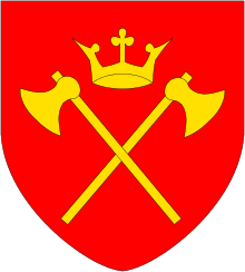
Coat-of-arms
The coat-of-arms was granted in the late 1940s. The arms show a golden Viking helmet on a blue background. The helmet and the color are derived from the belief that King Håkon the Good wore a golden helmet at the Battle of Fitjar in 961, which was fought in this municipality.[6]
Churches
The Church of Norway has one parish (sokn) within the municipality of Fitjar. It is part of the Sunnhordland deanery in the Diocese of Bjørgvin.
| Parish (Sokn) | Church Name | Location of the Church | Year Built |
|---|---|---|---|
| Fitjar | Fitjar Church | Fitjar | 1867 |
Government
All municipalities in Norway, including Fitjar, are responsible for primary education (through 10th grade), outpatient health services, senior citizen services, unemployment and other social services, zoning, economic development, and municipal roads. The municipality is governed by a municipal council of elected representatives, which in turn elect a mayor.
Municipal council
The municipal council (Kommunestyre) of Fitjar is made up of 17 representatives that are elected to four year terms. Currently, the party breakdown is as follows:[7]
| Party Name | Name in Norwegian | Number of representatives | |
|---|---|---|---|
| Labour Party | Arbeiderpartiet | 3 | |
| Progress Party | Framstegspartiet | 2 | |
| Conservative Party | Høgre | 7 | |
| Christian Democratic Party | Kristelig Folkeparti | 3 | |
| Centre Party | Senterpartiet | 2 | |
| Total number of members: | 17 | ||
History
| Historical population | ||
|---|---|---|
| Year | Pop. | ±% |
| 1951 | 3,092 | — |
| 1960 | 3,172 | +2.6% |
| 1970 | 2,520 | −20.6% |
| 1980 | 2,888 | +14.6% |
| 1990 | 3,072 | +6.4% |
| 2000 | 2,992 | −2.6% |
| 2010 | 2,931 | −2.0% |
| 2017 | 3,189 | +8.8% |
| Source: Statistics Norway. | ||
King Haakon I of Norway (Haakon the Good) maintained his residence at Fitjar. The Battle of Fitjar (Slaget ved Fitjar på Stord) took place in Fitjar on the island of Stord in the year 961 between the forces of King Haakon I and the sons of his half-brother, Eric Bloodaxe. Traditionally, important shipping routes have passed through the area, and the municipality contains several trading posts dating as far back as 1648. Fitjar was separated from Stord in 1863. There have been discussions about a possible reunion of the two municipalities, but no decision has been made.
Geography
The island municipality of Fitjar lies south of the Selbjørnsfjorden, west of the Langenuen strait, east of the island of Bømlo. The municipality includes over 350 islands, although most are uninhabited. The majority of the residents live on the island of Stord, the northern portion of which is in Fitjar. The southern portion of the island is part of the municipality of Stord. The island municipality of Austevoll lies to the north, across the fjord and the island municipality of Tysnes lies across the Langenuen strait to the east, and the island municipality of Bømlo lies to the west.[2]
Attractions

Fitjar Church was built in 1867 over the site of the old medieval stone church which had been demolished. Stone blocks taken from the old stone church were used as foundations for the present-day church as well as for the walling enclosing the churchyard. Opposite Fitjar Church is Haakon’s Park (Håkonarparken), the location of a sculpture of Haakon the Good sculpted by Anne Grimdalen. The statue was erected in 1961 at the one thousand year commemoration of the Battle of Fitjar.[8]
References
- ↑ "Navn på steder og personer: Innbyggjarnamn" (in Norwegian). Språkrådet. Retrieved 2015-12-01.
- 1 2 Store norske leksikon. "Fitjar" (in Norwegian). Retrieved 2015-01-28.
- ↑ Statistisk sentralbyrå (2017). "Table: 06913: Population 1 January and population changes during the calendar year (M)" (in Norwegian). Retrieved 2017-10-28.
- ↑ Jukvam, Dag (1999). "Historisk oversikt over endringer i kommune- og fylkesinndelingen" (PDF) (in Norwegian). Statistisk sentralbyrå.
- ↑ Rygh, Oluf (1910). Norske gaardnavne: Søndre Bergenhus amt (in Norwegian) (11 ed.). Kristiania, Norge: W. C. Fabritius & sønners bogtrikkeri. p. 156.
- ↑ "Civic heraldry of Norway - Norske Kommunevåpen". Heraldry of the World. Retrieved 2015-01-28.
- ↑ "Table: 04813: Members of the local councils, by party/electoral list at the Municipal Council election (M)" (in Norwegian). Statistics Norway. 2015.
- ↑ "Carwalk Fitjar". VisitNorway.com. Archived from the original on 2012-09-17.
External links
- Municipal fact sheet from Statistics Norway (in Norwegian)