Osterøy
| Osterøy kommune | |||
|---|---|---|---|
| Municipality | |||
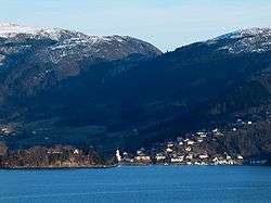 View of the village of Haus | |||
| |||
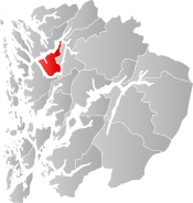 Osterøy within Hordaland | |||
| Coordinates: 60°31′05″N 05°32′29″E / 60.51806°N 5.54139°ECoordinates: 60°31′05″N 05°32′29″E / 60.51806°N 5.54139°E | |||
| Country | Norway | ||
| County | Hordaland | ||
| District | Nordhordland | ||
| Administrative centre | Lonevåg | ||
| Government | |||
| • Mayor (2015) | Jarle Skeidsvoll (KrF) | ||
| Area | |||
| • Total | 255.12 km2 (98.50 sq mi) | ||
| • Land | 243.69 km2 (94.09 sq mi) | ||
| • Water | 11.43 km2 (4.41 sq mi) | ||
| Area rank | #298 in Norway | ||
| Population (2017) | |||
| • Total | 8,026 | ||
| • Rank | #134 in Norway | ||
| • Density | 32.9/km2 (85/sq mi) | ||
| • Change (10 years) | 11.7% | ||
| Demonym(s) | Ostring[1] | ||
| Time zone | UTC+01:00 (CET) | ||
| • Summer (DST) | UTC+02:00 (CEST) | ||
| ISO 3166 code | NO-1253 | ||
| Official language form | Nynorsk | ||
| Website |
www | ||

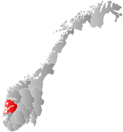
Osterøy is an island municipality in Hordaland county, Norway. It is located in the traditional district of Nordhordland. The municipality encompasses most of the island of Osterøy. The administrative centre of Osterøy is the village of Lonevåg in the central part of the island, while the settlement with the largest population is the village of Valestrandfossen with 1,219 inhabitants as of 1 January 2016.[2]
Osterøy municipality covers the majority of the island of the same name, and the mostly uninhabited north-eastern part of the island is part of Vaksdal municipality. Osterøy is located just northeast of the city of Bergen, and is surrounded by the Osterfjorden, Sørfjorden, and Veafjorden. The 19th-century musician and composer Ole Bull had a summer home in Valestrandfossen in Osterøy. The historic Havrå farm, which represents the traditional way of living for farmers, is located on the south side of the island.
The 255-square-kilometre (98 sq mi) municipality is the 298th largest by area out of the 422 municipalities in Norway. Osterøy is the 134th most populous municipality in Norway with a population of 8,026. The municipality's population density is 32.9 inhabitants per square kilometre (85/sq mi) and its population has increased by 11.7% over the last decade.[3]
Geography

The municipality sits on the island of Osterøy, and it is surrounded by several fjords: Osterfjorden-Romarheimsfjorden, Sørfjorden, and Veafjorden. The highest mountain in the municipality is the 868-metre (2,848 ft) tall Høgafjellet on the municipal border with Vaksdal. The Lonevågen fjord cuts in the center of the island, with the village of Lonevåg sitting at the end of the fjord.
Settlements
Osterøy contains six "urban settlements", as defined by Statistics Norway and as of 1 January 2016: Valestrandfossen (1,218 inhabitants), Lonevåg (875 inhabitants), Hausvik (655 inhabitants), Haugo (617 inhabitants), Fotlandsvåg (320 inhabitants), and Hamre (217 inhabitants).[2] Other rural settlements in Osterøy include Austbygdi, Bruvik, Gjerstad, and Hosanger.
History

| Historical population | ||
|---|---|---|
| Year | Pop. | ±% |
| 1951 | 2,688 | — |
| 1960 | 2,513 | −6.5% |
| 1970 | 5,660 | +125.2% |
| 1980 | 6,579 | +16.2% |
| 1990 | 7,016 | +6.6% |
| 2000 | 7,006 | −0.1% |
| 2010 | 7,412 | +5.8% |
| 2017 | 8,026 | +8.3% |
| Source: Statistics Norway | ||
The municipality of Osterøy was created on 1 January 1964 as part of a major municipal merger that was proposed by the Schei Committee. Osterøy was created from parts of four different municipalities that were all dissolved in the merger. The following areas were merged to form the new municipality of Osterøy:[4]
- all of Haus municipality that was located on Osterøy island (population: 2,327)
- the Bruvikbygda area of Bruvik municipality that was located on Osterøy island (population: 409)
- all of Hosanger municipality that was located on Osterøy island (population: 1,616)
- all of Hamre municipality that was located on Osterøy island (population: 1,166)
Name
The municipality was named after the island on which it is located. The Old Norse form of the name was "Ostr". The last element "øy" which means "island" in Norwegian was added later. The meaning of the name is unknown. It is possible that it comes from the word "óstr" which means "ost".
Culture
Coat-of-arms
The coat-of-arms for Osterøy municipality is a relatively new creation; it was granted on 20 December 1985. It shows three blue broad axes pointing downwards on a field of white, with two axes at the top and one beneath. Broad axes are used in the construction of timber houses, which has long traditions in the municipality. The designer was Egil Korsnes who based his design on the idea of Magnus Hardeland.[5]
Churches

The Church of Norway has one parish (sokn) within the municipality of Osterøy. It is part of the Arna og Åsane deanery in the Diocese of Bjørgvin.
| Parish (Sokn) | Church Name | Location of the Church | Year Built |
|---|---|---|---|
| Bruvik | Bruvik Church | Bruvik | 1867 |
| Gjerstad | Gjerstad Church | Gjerstad | 1870 |
| Hamre | Hamre Church | Hamre | 1622 |
| Haus | Haus Church | Hausvik | 1874 |
| Hosanger | Hosanger Church | Hosanger | 1796 |
Government
All municipalities in Norway, including Osterøy, are responsible for primary education (through 10th grade), outpatient health services, senior citizen services, unemployment and other social services, zoning, economic development, and municipal roads. The municipality is governed by a municipal council of elected representatives, which in turn elect a mayor.
Municipal council
The municipal council (Kommunestyre) of Osterøy is made up of 27 representatives that are elected to four year terms. Currently, the party breakdown is as follows:[6]
| Party Name | Name in Norwegian | Number of representatives | |
|---|---|---|---|
| Labour Party | Arbeiderpartiet | 8 | |
| Progress Party | Framstegspartiet | 6 | |
| Conservative Party | Høgre | 4 | |
| Christian Democratic Party | Kristelig Folkeparti | 4 | |
| Green Party | Miljøpartiet Dei Grøne | 2 | |
| Centre Party | Senterpartiet | 2 | |
| Liberal Party | Venstre | 1 | |
| Total number of members: | 27 | ||
Mayor
Currently, the mayor is Jarle Skeidsvoll of the Christian Democratic Party. He was elected in 2015 and will serve until 2019. From 2003-2015, the mayor of Osterøy was Kari Foseid Aakre from the Labour Party.[7]
Transport
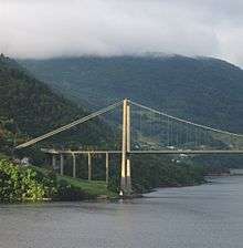
Osterøy is connected to the mainland by a ferry from Breistein to Valestrand, and by a bridge on the far southern end of the island. The ferry named "Ole Bull" is sailing every half-hour from Breistein and Valestrand from early morning to late in the evening. The Osterøy Bridge, finished in 1997, provides Osterøy with its only permanent road connection to the mainland in Bergen municipality. The bridge has a main span of 595 metres (1,952 ft), the third longest suspension bridge main span in Norway, for a total length of 917 metres (3,009 ft). Since 2015, the bridge has been toll-free. There are no road connections from Osterøy municipality to the Vaksdal municipality part of Osterøy island. That part of the island has the Kallestadsundet Bridge connecting it to the rest of Vaksdal municipality from the east.
People from Osterøy
- Tore Eikeland (1990-2011), a politician
- Erlend Hanstveit (born 1981), a footballer
- Mons Ivar Mjelde (born 1967), a footballer and coach
- Sylvelin Vatle (born 1957), a novelist and children's writer
- Carl Espen (born 1982), a musician
- Vinskvetten, a Norwegian music and comedy troupe
See also
- nn:Bygdanytt, the local newspaper (in Norwegian)
References
- ↑ "Navn på steder og personer: Innbyggjarnamn" (in Norwegian). Språkrådet. Retrieved 2015-12-01.
- 1 2 Statistisk sentralbyrå (1 January 2016). "Urban settlements. Population and area, by municipality".
- ↑ Statistisk sentralbyrå (2017). "Table: 06913: Population 1 January and population changes during the calendar year (M)" (in Norwegian). Retrieved 2018-01-05.
- ↑ Jukvam, Dag (1999). "Historisk oversikt over endringer i kommune- og fylkesinndelingen" (PDF) (in Norwegian). Statistisk sentralbyrå.
- ↑ "Civic heraldry of Norway - Norske Kommunevåpen". Heraldry of the World. Retrieved 2014-04-29.
- ↑ "Table: 04813: Members of the local councils, by party/electoral list at the Municipal Council election (M)" (in Norwegian). Statistics Norway. 2015.
- ↑ "Osterøy kommune" (in Norwegian). Osterøy kommune. Retrieved 2008-09-10.
External links
| Wikimedia Commons has media related to Osterøy. |
- Municipal fact sheet from Statistics Norway (in Norwegian)