Sæbøvik
| Sæbøvik | |
|---|---|
| Village | |
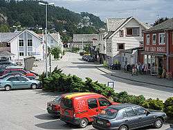 View of the village | |
 Sæbøvik Location in Hordaland county  Sæbøvik Sæbøvik (Norway) | |
| Coordinates: 59°47′38″N 05°42′34″E / 59.79389°N 5.70944°ECoordinates: 59°47′38″N 05°42′34″E / 59.79389°N 5.70944°E | |
| Country | Norway |
| Region | Western Norway |
| County | Hordaland |
| District | Sunnhordland |
| Municipality | Kvinnherad |
| Area[1] | |
| • Total | 0.75 km2 (0.29 sq mi) |
| Elevation[2] | 4 m (13 ft) |
| Population (2013)[1] | |
| • Total | 530 |
| • Density | 707/km2 (1,830/sq mi) |
| Time zone | UTC+01:00 (CET) |
| • Summer (DST) | UTC+02:00 (CEST) |
| Post Code | 5454 Sæbøvik |
Sæbøvik is a village in Kvinnherad municipality in Hordaland county, Norway. The village is located on the narrow, western part of the island of Halsnøya, about 6 kilometres (3.7 mi) west of the village of Høylandsbygd and immediately east of the village of Eidsvik. The village is located at the southern end of the Halsnøy Tunnel.[3]
The 0.75-square-kilometre (190-acre) village of Sæbøvik has a population (2013) of 530, giving the village a population density of 707 inhabitants per square kilometre (1,830/sq mi). This makes it the largest urban area on the island, just after the neighboring village of Eidsvik.[1]
References
- 1 2 3 Statistisk sentralbyrå (1 January 2013). "Urban settlements. Population and area, by municipality".
- ↑ "Sæbøvik, Kvinnherad (Hordaland)" (in Norwegian). yr.no. Retrieved 2015-03-17.
- ↑ Store norske leksikon. "Sæbøvik" (in Norwegian). Retrieved 2015-03-17.
This article is issued from
Wikipedia.
The text is licensed under Creative Commons - Attribution - Sharealike.
Additional terms may apply for the media files.