Hatlestrand
| Hatlestrand | |
|---|---|
| Village | |
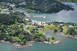 View of the village | |
 Hatlestrand Location in Hordaland county  Hatlestrand Hatlestrand (Norway) | |
| Coordinates: 60°02′47″N 05°54′07″E / 60.04639°N 5.90194°ECoordinates: 60°02′47″N 05°54′07″E / 60.04639°N 5.90194°E | |
| Country | Norway |
| Region | Western Norway |
| County | Hordaland |
| District | Sunnhordland |
| Municipality | Kvinnherad |
| Area[1] | |
| • Total | 0.22 km2 (0.08 sq mi) |
| Elevation[2] | 53 m (174 ft) |
| Population (2013)[1] | |
| • Total | 227 |
| • Density | 1,032/km2 (2,670/sq mi) |
| Time zone | UTC+01:00 (CET) |
| • Summer (DST) | UTC+02:00 (CEST) |
| Post Code | 5635 Hatlestrand |
Hatlestrand is a village in Kvinnherad municipality in Hordaland county, Norway. The village is located along the Hardangerfjorden, northeast of the villages of Husa and Ølve. The village has a ferry port called Gjermundshamn, which has regular ferry connections to the island of Varaldsøy and to Årsnes on the opposite side of the fjord. Hatlestrand Church is located in the village.[3]
The 0.22-square-kilometre (54-acre) urban area of Gjermundshamn has a population (2015) of 225, giving the village a population density of 1,023 inhabitants per square kilometre (2,650/sq mi).[1] The rest of the Hatlestrand area is more rural with another 250 residents.
References
- 1 2 3 Statistisk sentralbyrå (1 January 2013). "Urban settlements. Population and area, by municipality".
- ↑ "Hatlestranda, Kvinnherad (Hordaland)" (in Norwegian). yr.no. Retrieved 2015-03-24.
- ↑ Store norske leksikon. "Gjermundshamn" (in Norwegian). Retrieved 2015-03-24.
This article is issued from
Wikipedia.
The text is licensed under Creative Commons - Attribution - Sharealike.
Additional terms may apply for the media files.