Khagrachhari District
| Khagrachhari খাগড়াছড়ি | |
|---|---|
| District | |
| Nickname(s): প্রাকৃতিক সৌন্দর্যের রাণী (The Queen of Natural Beauty)/উপত্যকার শহর (The City of Valleys) | |
| Motto(s): বৈচিত্র্যে সৌন্দর্য (Beauty Lies in Diversity) | |
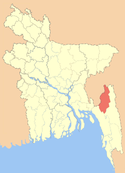 Location of Khagrachhari in Bangladesh | |
| Coordinates: 23°02′30″N 91°59′40″E / 23.0417°N 91.9944°ECoordinates: 23°02′30″N 91°59′40″E / 23.0417°N 91.9944°E | |
| Country |
|
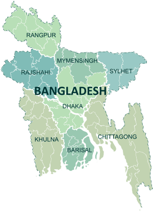
| Division | Chittagong Division |
| Area | |
| • Total | 2,749.16 km2 (1,061.46 sq mi) |
| Population (2011 census) | |
| • Total | 613,917 |
| • Density | 220/km2 (580/sq mi) |
| Demonym(s) | Khagrasoria |
| Time zone | UTC+6 (BST) |
| Postal code | 4400 |
| Website |
www |
Khagrachhari (Bengali: খাগড়াছড়িBengali pronunciation: [khagrat͡ɕʰori/khagrat͡sʰori]), also known as Chengmi (Chakma:𑄌𑄬𑄋𑄴𑄟𑄩) is a district in Chittagong Division, south-eastern Bangladesh[1] and the Chittagong Hill Tracts.[2]
Khagrachhari is also known as Phalang Htaung (ဖလံထောင်) or the Mong Circle (of the rest of the three hill districts Rangamati is the Chakma Circle (သက်ထောင်) and Bandarban (ဗိုလ်မင်းထောင်) is the Bohmong Circle). Khagrachhari town is the hometown of the Mong Chief (currently King, or Raja, Saching Prue Chowdhury ဗိုလ်မင်း သာစိန်ဖြူ) who is the head of the Arakanese descendants living in the circle.[3]
History
The Chittagong Hill Tracts was under the reign of the Tripura State, the Arakans and the Sultans in different times before it came under the control of the British East India Company in 1760. Although the British got the authority of the Chittagong Hill Tracts in 1760, they had no authority besides collecting nominal taxes. Until 1860, two kings or chiefs governed the internal administration of this region. In 1860, another circle was formed in present Khagrachhari zila, inhabited by the Tripura population. The chief or the Raja of this circle was selected from the minority Marma population. The circle was named after the Tripura dialect the Mun Circle, but later, the 'Mun dialect', was changed and renamed as Mong Circle. In 1900 the British offered independent status to Chittagong Hill Tracts recognizing the culture and language of the hill tracts population. But during The Partition of Indian sub-continent this status was abolished and became part of East-Bangladesh, ruled under Pakistan.Then, the name of this subdivision was Ramgarh with its headquarters at Khagrachhari. It was upgraded to zila in 1983. The zila headquarters is located on the bank of the 'Chengi' stream (meaning Chhara in local language) which was full of Catkin plants (meaning Khagra in local language). It is believed that the zila might have derived its name from the above two words 'Khagra' and 'Chhara'. Khagrachhari Local Govt. Council was established on 6 March 1989 to uphold the political, social, cultural, educational and economic right and to expedite the process of socio-economic development of all residents of Khagrachhari Hill District. According to 'Peace Accord' this council was renamed as “Khagrachari Hill District Council (KHDC)” by the Act-10 of 1998. Now this council has been regarded as the main focal point of administration as well as development activities of the district.
Geography
Khagrachari is a hilly area. It is bounded by the tripura state of India on the north, Rangamati and chittagong districts on the south, Rangamati district on the east, Chittagong District and Tripura state of India on the west. Notable hill ranges are Golamoon, Chotto Panchari, Karmi Mura, Lutiban, Kuradia, Bhanga Mura, Jopisil.
It has three rivers, namely Chengi, Feni and Maini. Chengi is the longest river in Khagrachhari.The main ethnic groups living in the district are Tripuris, Chakmas, Bengalis and Marmas.
Demographics
According to Bangladesh Population Census 2011, total Population is 6,13,917, with an annual growth rate of 1.54%; male 3,13,793, female 300,124; Muslim 3,82,849, Hindu 89,102, Buddhist 1,39,603 Christian 2157 and others 207.Indigenous communities such as Chakma, Marma, Tripura and Tanchangya belong to this zilla. [4] [5]
As per the 2011 Census, there were a total of 316,987 indigenous people in the district (51.63%)[6].
Subdivisions
Upazilas under this district are:
Administration
Khagrachhari district consist of 3 Paurashava,9 Upzila/Thana,38 Union,122 Mauza,27 Ward,153 Mahalla and 1,702 Villages.The upazilas are Dighinala, Khagrachhari Sadar, Lakshmichhari, Mahalchhari, Manikchhari, Matiranga, Panchhari, Ramgarh and Guimara. Deputy Commissioner (DC): Muhammad Wahiduzzaman
Chairman of Hill District Council: Mr. Kongjari Chowdhury
Mong king: Saching Prue Chowdhury [7]
Economy
Most of the people live on Jhum cultivation. There are also people of various professions like Teacher, Farmer and Businessmen.
Main sources of income Agriculture 59.92%, non-agricultural labourer 9.33%, industry 0.44%, commerce 10.67%, transport and communication 1.11%, service 7.94%, construction 0.92%, religious service 0.24%, rent and remittance 0.37% and others 9.06%.
Education
Literacy rate (7+ year) 46.1%; male 51.9%, female 40.1%. Noted educational institutions: Khagrachhari Government College (1974), Matiranga Degree College (1992), Ramgarh Government Degree College (1980), Panchhari College (1990), Dighinala Government College, Khagrachhri Cantonmet public school and college(2006), Panchhari High School and College (1981), Khagrachhari Government High School (1957), Tabalchhari TK High School (1952), Ramgarh Government High School (1952), Rani Nihar Devi Government High School (1976), Dighinala Government High School, Choto Merung High School(1975), Khagrachhari North Khobongpodia Government Primary School (1905).
Religious composition (2011)
Source[11]
| Religion | 1991 | 2001 | 2011 | Perc 2011 | PGR 91-11 |
| Muslim | 162,504 | 228,753 | 274,258 | 44.7% | 68.8% |
| Hindu | 57,158 | 86,351 | 103,195 | 16.8% | 80.5% |
| Christian | 939 | 3,745 | 4,070 | 0.7% | 333.4% |
| Buddhist | 121,631 | 206,473 | 231,309 | 37.7% | 90.2% |
| Others | 256 | 342 | 1,085 | 0.2% | 323.8% |
| Total | 342,488 | 525,664 | 613,917 | 100.0% | 79.3% |
Archaeological Heritage and Relics
Among the archaeological heritages and relics, Rajbari of the Mong Circle and Dighi (large pond) of Dighinala (excavated by Gobindo Manikko exiled king of Tripura) are notable. [12]
Transport
Palanquin, elephant cart, buffalo cart, horse carriage, bullock cart and country boat were the traditional transports once found in the rural area of the zila. These means of transport are either extinct or nearly extinct except country boat. Now-a-days, all the upazilas are connected to the zila headquarters by metalled roads. Bus, minibus, three wheelers ply over the zila. Chander Gari (local four wheeled jeep) is a popular transport used to ply in the hill area of the zila.[13]
Climate
Temperature and Rainfall: The annual average temperature of the zila varies from maximum 34.6°C to minimum 13°C and the average annual rainfall is 3031 mm.
Member of Tenth Parliament
Khagrachhari Seat 298: Kujendra Laal Tripura (from Awami League).[14][15] Before Kejendra Laal Tripura, Jatindra Laal Tripura and then Wadud Bhuiyan was the Member of Parliament of Khagrachhari Seat 298. He was also the Chairman of the Chittagong Hill Tracts Development Board at that period. Wadud Bhuiyan was two times MP.
See also
References
| Wikimedia Commons has media related to Khagrachhari District. |
- ↑ Tripura, Barendro Lal (2012). "Khagrachhari District". In Islam, Sirajul; Jamal, Ahmed A. Banglapedia: National Encyclopedia of Bangladesh (Second ed.). Asiatic Society of Bangladesh.
- ↑ Chowdhury, Sifatul Quader (2012). "Chittagong Hill Tracts". In Islam, Sirajul; Jamal, Ahmed A. Banglapedia: National Encyclopedia of Bangladesh (Second ed.). Asiatic Society of Bangladesh.
- ↑ “Khagrachari Hill District Council,” last modified 2013, http://www.khdcbd.org/home/programs.
- ↑ http://www.khagrachhari.gov.bd/site/view/tourist_spot
- ↑ http://www.bbs.gov.bd/site/page/47856ad0-7e1c-4aab-bd78-892733bc06eb/%E0%A6%AA%E0%A6%AA%E0%A7%81%E0%A6%B2%E0%A7%87%E0%A6%B6%E0%A6%A8-%E0%A6%8F%E0%A6%A8%E0%A7%8D%E0%A6%A1-%E0%A6%B9%E0%A6%BE%E0%A6%89%E0%A6%9C%E0%A6%BF%E0%A6%82-%E0%A6%B8%E0%A7%87%E0%A6%A8%E0%A7%8D%E0%A6%B8%E0%A6%BE%E0%A6%B8
- ↑ http://archive.prothom-alo.com/detail/date/2012-08-17/news/282516
- ↑ http://www.bbs.gov.bd/site/page/47856ad0-7e1c-4aab-bd78-892733bc06eb/%E0%A6%AA%E0%A6%AA%E0%A7%81%E0%A6%B2%E0%A7%87%E0%A6%B6%E0%A6%A8-%E0%A6%8F%E0%A6%A8%E0%A7%8D%E0%A6%A1-%E0%A6%B9%E0%A6%BE%E0%A6%89%E0%A6%9C%E0%A6%BF%E0%A6%82-%E0%A6%B8%E0%A7%87%E0%A6%A8%E0%A7%8D%E0%A6%B8%E0%A6%BE%E0%A6%B8
- ↑ http://www.pbm-cht.org/
- ↑ http://www.bdeducationonline.com/khagrachariclg/index.php?option=com_content&view=article&id=1:khagrachari-govt-college&catid=1:latest-news
- ↑ http://en.banglapedia.org/index.php?title=Khagrachhari_District
- ↑ https://alalodulal.org/2014/04/12/hindu-population-gap/
- ↑ http://www.bbs.gov.bd/site/page/47856ad0-7e1c-4aab-bd78-892733bc06eb/%E0%A6%AA%E0%A6%AA%E0%A7%81%E0%A6%B2%E0%A7%87%E0%A6%B6%E0%A6%A8-%E0%A6%8F%E0%A6%A8%E0%A7%8D%E0%A6%A1-%E0%A6%B9%E0%A6%BE%E0%A6%89%E0%A6%9C%E0%A6%BF%E0%A6%82-%E0%A6%B8%E0%A7%87%E0%A6%A8%E0%A7%8D%E0%A6%B8%E0%A6%BE%E0%A6%B8
- ↑ http://www.bbs.gov.bd/site/page/47856ad0-7e1c-4aab-bd78-892733bc06eb/%E0%A6%AA%E0%A6%AA%E0%A7%81%E0%A6%B2%E0%A7%87%E0%A6%B6%E0%A6%A8-%E0%A6%8F%E0%A6%A8%E0%A7%8D%E0%A6%A1-%E0%A6%B9%E0%A6%BE%E0%A6%89%E0%A6%9C%E0%A6%BF%E0%A6%82-%E0%A6%B8%E0%A7%87%E0%A6%A8%E0%A7%8D%E0%A6%B8%E0%A6%BE%E0%A6%B8
- ↑ "Archived copy". Archived from the original on 2012-12-27. Retrieved 2013-01-09.
- ↑ "Archived copy". Archived from the original on 2013-08-25. Retrieved 2013-08-28.
| Upazila/Thana: | ||
|---|---|---|