Kesennuma
| Kesennuma 気仙沼市 | |||
|---|---|---|---|
| City | |||
 Kesennuma City Hall | |||
| |||
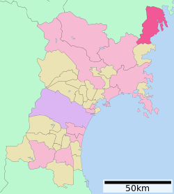 Location of Kesennuma in Miyagi Prefecture | |||
 Kesennuma | |||
| Coordinates: 38°54′29″N 141°34′11.8″E / 38.90806°N 141.569944°ECoordinates: 38°54′29″N 141°34′11.8″E / 38.90806°N 141.569944°E | |||
| Country | Japan | ||
| Region | Tōhoku | ||
| Prefecture | Miyagi | ||
| Government | |||
| • Mayor | Noboru Suzuki | ||
| Area | |||
| • Total | 332.44 km2 (128.36 sq mi) | ||
| Population (May 31, 2017) | |||
| • Total | 65,367 | ||
| • Density | 197/km2 (510/sq mi) | ||
| Time zone | UTC+9 (Japan Standard Time) | ||
| - Tree | Japanese Black Pine | ||
| - Flower | Azalea | ||
| - Bird | Seagull | ||
| - Fish | Bonito | ||
| Phone number | 0226-22-6600 | ||
| Address | 1-1-1 Yōka-machi, Kesennuma-shi 988-8501 | ||
| Website | http://www.kesennuma.miyagi.jp/ | ||


Kesennuma (気仙沼市 Kesennuma-shi) is a city in Miyagi Prefecture, Japan. As of 31 May 2017, the city had an estimated population of 65,367 and a population density of 197 inhabitants per square kilometre (510/sq mi)in 26,429 households.[1] The total area of the city is 332.44 square kilometres (128.36 sq mi). Large sections of the city were destroyed by the 2011 Tōhoku earthquake and tsunami and major fires on March 11, 2011.[2]
Geography
Kesennuma is in the far northeastern corner of Miyagi Prefecture. The city wraps around the western part of Kesennuma Bay and also includes the island of Ōshima. Its deeply indented rias coastline forms the southern boundary of the Sanriku Fukkō National Park, which stretches north to Aomori Prefecture.
The city borders Hirota Bay, Kesennuma Bay, and the Pacific Ocean to the east and Minamisanriku, Miyagi to the south. Iwate Prefecture makes up the remainder of its borders, with the city of Ichinoseki to the west, and the city of Rikuzen-Takata to the north. The highest point in Kesennuma is the 711.9 metres (2,336 ft) high Mount Ōmori, on the border with Motoyoshi, while the lowest point is at sea level. The Ōkawa River flows through the city and into Kesennuma Bay.
Neighboring municipalities
- Miyagi Prefecture
- Iwate Prefecture
Climate

Kesennuma has a humid climate (Köppen climate classification Cfa) characterized by mild summers and cold winters. The average annual temperature in Kesennuma is 10.6 °C. The average annual rainfall is 1279 mm with September as the wettest month. The temperatures are highest on average in August, at around 23.3 °C, and lowest in January, at around -0.7 °C.[3] Its record high is 36.0 °C (96.8 °F) on August 15, 1994, and its record low is −12.6 °C (9.3 °F) on February 17, 1980.
Demographics
Per Japanese census data,[4] the population of Kesennuma has declined over the past 40 years.
| Census Year | Population |
|---|---|
| 1970 | 87,914 |
| 1980 | 92,246 |
| 1990 | 88,152 |
| 2000 | 82,394 |
| 2010 | 73,489 |
History
The area of present-day Kesennuma was part of ancient Mutsu Province and has been settled since at least the Jōmon period by the Emishi people, as evidenced by numerous shell middens found in coastal areas. During the later portion of the Heian period, the area was ruled by the Northern Fujiwara. During the Sengoku period, the area was contested by various samurai clans before the area came under the control of the Date clan of Sendai Domain during the Edo period, under the Tokugawa shogunate. The town of Kesennuma was established on June 1, 1889 within Motoyoshi District, Miyagi with the establishment of the modern municipalities system.
Kesennuma City was formed on June 1, 1953, when the town of Kesennuma annexed the neighboring town of Shishiori and village of Matsuiwa. On April 1, 1955, the city annexed the villages of Niitsuki, Hashikami and Oshima. On March 31, 2006, the town of Karakuwa and on September 1, 2009 the town of Motoyoshi (both from Motoyoshi District were likewise incorporated into Kesennuma.
On March 11, 2011, large parts of the city were destroyed by the tsunami which followed the Tōhoku earthquake. The island of Ōshima and its 3,000 residents, included in the city limits, was isolated by the tsunami which damaged the ferry connections.[5] After the tsunami, spilled fuel from the town's fishing fleet caught fire and burned for four days.[6] As of 22 April 2011, the city had confirmed 837 deaths with 1,196 missing.[7]
In August 2013, residents decided to scrap a fishing boat - the Kyotoku Maru No 18 - which was swept inland by a giant wave during the 2011 tsunami. There had been plans to preserve the boat as a monument, as it had become a symbol of the tsunami.[8]
In 2014, Kesennuma was designated as Japan's first "slow town".[9]
Economy

Kesennuma relies on tourism and commercial fishing, the latter being what the city is known for, especially its shark, tuna, pacific saury and skipjack tuna production, keeping the fishing port very active. Prior to the 2011 disaster, the city was Japan's busiest port for processing bonito and swordfish. Presently, fishing and associated industries account for 85% of jobs in the town.[10]
Government
Kesennuma has a mayor-council form of government with a directly elected mayor and a unicameral city legislature of 24 members.
Education
Kesennuma has 14 public elementary schools and eight junior high schools operated by the town government, and four public high schools operated by the Miyagi Prefectural Board of Education and one private high school.[11] The prefectural government also operates one special educational school.
Transportation
Railway
- East Japan Railway Company (JR East) – Kesennuma Line (operations suspended indefinitely and replaced by a BRT system)
- Kurauchi - Rikuzen-Koizumi - Motoyoshi - Koganezawa - Ōya-Kaigan - Rikuzen-Hashikami - Saichi - Matsuiwa - Minami-Kesennuma - Fudōnosawa - Kesennuma
- East Japan Railway Company (JR East) – Ōfunato Line (operations suspended indefinitely and replaced by a BRT system)
Highway
National highways
Sister/friendship cities
International


Japanese sister cities

Noted people from Kesennuma
- Satoru Kanemura – professional baseball player
- Isshin Chiba – voice actor
- Tetsuo Kanno – politician
- Itsunori Onodera – politician
- Rikako Sasaki – idol singer
References
- ↑ Kesennuma City official home page (in Japanese)
- ↑ "Blaze engulfs northeast Japan waterfront after quake". Reuters. March 11, 2011. Retrieved March 11, 2011.
- ↑ Kesennuma climate data
- ↑ Kesennumapopulation statistics
- ↑ Asahi Shimbun, "Islanders cut off from mainland due to tsunami", 29 March 2011.
- ↑ The Economist, "Disaster in Japan: Come back in ten years' time", 26 March 2011, pp. 47-48.
- ↑ Bloomberg L.P., "Tsunami abetted fishing sector fall", The Japan Times, 26 April 2011, p. 8.
- ↑ Wingfield-Hayes, Rupert. "Japanese town to scrap marooned 'tsunami boat'". BBC News. Retrieved 13 August 2013.
- ↑ Cittaslow official home page
- ↑ Matsuyama, Kanoko, and Stuart Biggs, (Bloomberg L.P.), "Tsunami - insult to injury", Japan Times, 30 April 2011, p. 3.
- ↑ Kesennuma City home page (in Japanese)
- 1 2 3 "International Exchange". List of Affiliation Partners within Prefectures. Council of Local Authorities for International Relations (CLAIR). Archived from the original on 22 December 2015. Retrieved 21 November 2015.
External links
| Wikimedia Commons has media related to Kesennuma. |
- Official Website (in Japanese)
- Eyewitness film of tsunami—caused by the 2011 Sendai earthquake—destroying Kesennuma in less than seven minutes
| Wards of Sendai | |
|---|---|
| Cities | |
| Districts | |
| Geology | |||||||||||||||
|---|---|---|---|---|---|---|---|---|---|---|---|---|---|---|---|
| Affected areas |
| ||||||||||||||
| Affected infrastructure |
| ||||||||||||||
| Nuclear Accidents and Incidents |
| ||||||||||||||
| Foreshocks, Aftershocks |
| ||||||||||||||
| People | |||||||||||||||
| Relief and Recovery |
| ||||||||||||||
| Media |
| ||||||||||||||
| Other | |||||||||||||||
| Authority control |
|---|