Wakuya
| Wakuya 涌谷町 | |||
|---|---|---|---|
| Town | |||
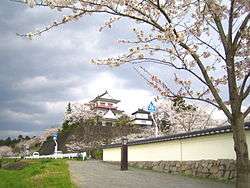 Wakuya Castle | |||
| |||
 Location of Wakuya in Miyagi Prefecture | |||
 Wakuya | |||
| Coordinates: 38°32′23″N 141°07′41.4″E / 38.53972°N 141.128167°ECoordinates: 38°32′23″N 141°07′41.4″E / 38.53972°N 141.128167°E | |||
| Country | Japan | ||
| Region | Tōhoku | ||
| Prefecture | Miyagi | ||
| District | Tōda | ||
| Area | |||
| • Total | 82.16 km2 (31.72 sq mi) | ||
| Population (June 30, 2017) | |||
| • Total | 16,703 | ||
| • Density | 203/km2 (530/sq mi) | ||
| Time zone | UTC+9 (Japan Standard Time) | ||
| - Tree | Cryptomeria | ||
| - Flower | Sakura | ||
| Phone number | 0229-43-2111 | ||
| Address | 153-2 Shinmachiura, Wakuya-chō, Tōda-gun, Miyagi-ken 987-0192 | ||
| Website | http://www.town.wakuya.miyagi.jp/ | ||


Wakuya (涌谷町 Wakuya-chō) is a town located in Miyagi Prefecture, Japan. As of 30 June 2017, the town had an estimated population of 16,703, and a population density of 203 persons per km² in 6,076 households.[1] The total area of the town is 82.16 square kilometres (31.72 sq mi). The area is noted for its rice production.
Geography
Wakuya is in north-central Miyagi Prefecture.
Neighboring municipalities
- Miyagi Prefecture
Demographics
Per Japanese census data,[2] the population of Wakuya has declined over the past 40 years.
| Census Year | Population |
|---|---|
| 1970 | 20,935 |
| 1980 | 21,319 |
| 1990 | 20,871 |
| 2000 | 19,313 |
| 2010 | 17,494 |
Climate
Wakuya has a humid climate (Köppen climate classification Cfa) characterized by mild summers and cold winters. The average annual temperature in Wakuya is 11.0 °C. The average annual rainfall is 1224 mm with September as the wettest month. The temperatures are highest on average in August, at around 23.9 °C, and lowest in January, at around -0.7 °C.[3]
History
The area of present-day Wakuya was part of ancient Mutsu Province, and has been settled since at least the Jōmon period by the Emishi people. During the Nara period, gold was discovered in the area. During later portion of the Heian period, the area was ruled by the Northern Fujiwara. During the Sengoku period, the area was contested by various samurai clans before the area came under the control of the Date clan of Sendai Domain during the Edo period, under the Tokugawa shogunate.
The town of Wakuya was established on June 1, 1889 with the establishment of the modern municipalities system. The town annexed the neighboring village of Moto-Wakuya on December 1, 1948, and the village of Nonodake on July 15, 1955. The 2011 Tōhoku earthquake and tsunami destroyed numerous buildings in the town, and resulted in one fatality.
Economy
The economy of Wakuya is largely based on agriculture, primarily the cultivation of rice, spinach, and spring onions. Alps Electric has a manufacturing plant in Wakuya.
Education

Wakuya has three public elementary schools (Wakuya No.1 Elementary school(涌谷第一小学校), Gesshoukan Elementary school(月将館小学校), Nonodake Elementary school(箟岳小学校)) and one public junior high school (Wakuya Middle School(涌谷中学校}) operated by the town government. [4] The town has one public high school operated by the Miyagi Prefecturing Board of Education.
Transportation
Railway
- East Japan Railway Company (JR East) – Ishinomaki Line
- East Japan Railway Company (JR East) – Kesennuma Line
Highway
Local attractions
- Koganeyama Jinja, a Shinto shrine founded in the Nara period (National Historic Site)
- Wakuya Castle
Sister city relations


Noted people from Wakuya
- Kōji Wakamatsu – film director
- Saitō Chikudō – Edo-period scholar
References
- ↑ Wakuya town official home page(in Japanese)
- ↑ Wakuya population statistics
- ↑ climate data
- ↑ Wakuya town official home page
- 1 2 "International Exchange". List of Affiliation Partners within Prefectures. Council of Local Authorities for International Relations (CLAIR). Retrieved 21 November 2015.
External links
| Wikimedia Commons has media related to Wakuya. |
- Official Website (in Japanese)