Kawasaki, Miyagi
| Kawasaki 川崎町 | |||
|---|---|---|---|
| Town | |||
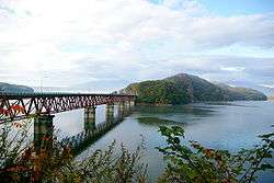 Kamafusa Lake in Kawasaki | |||
| |||
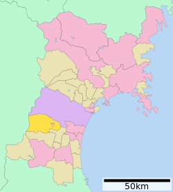 Location of Kawasaki in Miyagi Prefecture | |||
 Kawasaki | |||
| Coordinates: 38°10′40.4″N 140°38′23″E / 38.177889°N 140.63972°ECoordinates: 38°10′40.4″N 140°38′23″E / 38.177889°N 140.63972°E | |||
| Country | Japan | ||
| Region | Tōhoku | ||
| Prefecture | Miyagi | ||
| District | Shibata | ||
| Area | |||
| • Total | 270.77 km2 (104.54 sq mi) | ||
| Population (August 2017) | |||
| • Total | 8,950 | ||
| • Density | 33/km2 (90/sq mi) | ||
| Time zone | UTC+9 (Japan Standard Time) | ||
| - Tree | Enkianthus perulatus | ||
| - Flower | Rhododendron subg. Hymenanthes | ||
| Phone number | 0224-55-2111 | ||
| Address | Maekawa Urate 175-1, Kawasaki-machi, Shibata-gun, Miyagi-ken 989-1592 | ||
| Website | http://www.town.kawasaki.miyagi.jp/ | ||

Kawasaki (川崎町 Kawasaki-machi) is a town located in Miyagi Prefecture, Japan. As of 1 August 2017, the town had an estimated population of 8,950, and a population density of 33 persons per km² in 3,298 households.[1] The total area of the town is 270.77 square kilometres (104.54 sq mi).
Geography
Kawasaki is located in south-western Miyagi Prefecture, bordered by the Ōu Mountains to the west. Mount Zaō (1840.8 meters) is partly within the borders of Kawasaki. About 85% of the town area is classified as mountainous. Kawasaki has a humid climate (Köppen climate classification Cfa) characterized by mild summers and cold winters. The average annual temperature in Kawasaki is 11.0 °C. The average annual rainfall is 1318 mm with September as the wettest month. The temperatures are highest on average in August, at around 24.1 °C, and lowest in January, at around -0.9 °C.[2]
Neighboring municipalities
- Miyagi Prefecture
- Yamagata Prefecture
Demographics
Per Japanese census data,[3] the population of Kawasaki has remained fairly static over the past 40 years.
| Census Year | Population |
|---|---|
| 1970 | 10,344 |
| 1980 | 10,636 |
| 1990 | 10,797 |
| 2000 | 10,871 |
| 2010 | 9,978 |
History
The area of present-day Kawasaki was part of ancient Mutsu Province, and was part of the holdings of Sendai Domain under the Edo period Tokugawa shogunate. The village of Kawasaki was established on April 1, 1889 with the establishment of post-Meiji restoration modern municipalities system. It was promoted to town status on May 3, 1948. Kawasaki merged with the neighboring town of Tomioka on April 20, 1955.
Economy
The economy of Kawasaki is largely based on agriculture and forestry.
Education
- Kawasaki has four public elementary schools and two public middle schools operated by the town government, one public high school operated by the Miyagi Prefectural Board of Education.
Transportation
Railway
Kawasaki is not served by any passenger train lines.
Highway
- Yamagata Expressway: Miyagi-Kawasaki and Sasaya IC
- National Route 286
- National Route 457
Local attractions
- Kamafusa Dam
- Site of Kawasaki Castle
References
External links
![]()
- Official Website (in Japanese)