Kami, Miyagi
| Kami 加美町 | |||
|---|---|---|---|
| Town | |||
 Mount Funagata | |||
| |||
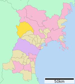 Location of Kami in Miyagi Prefecture | |||
 Kami | |||
| Coordinates: 38°34′18.3″N 141°51′17.3″E / 38.571750°N 141.854806°ECoordinates: 38°34′18.3″N 141°51′17.3″E / 38.571750°N 141.854806°E | |||
| Country | Japan | ||
| Region | Tōhoku | ||
| Prefecture | Miyagi | ||
| District | Kami | ||
| Area | |||
| • Total | 460.67 km2 (177.87 sq mi) | ||
| Population (May 2017) | |||
| • Total | 24,004 | ||
| • Density | 52.1/km2 (135/sq mi) | ||
| Time zone | UTC+9 (Japan Standard Time) | ||
| City symbols | |||
| • Tree | Siebold’s beech | ||
| • Flower | Asian skunk cabbage | ||
| • Bird | Green pheasant | ||
| • Fish | Ayu | ||
| Phone number | 0229-63-3111 | ||
| Address | 3-5 Nishida, Kami-chō, Kami-gun, Miyagi-ken 981-4292 | ||
| Website | http://www.town.kami.miyagi.jp/ | ||


Kami (加美町 Kami-machi) is a town located in Miyagi Prefecture, Japan. As of 31 May 2017, the town had an estimated population of 24,004 and a population density of 52.1 persons per km2 in 8014 households[1]. The total area of the town is 460.67 square kilometres (177.87 sq mi). .
Geography
Kami is located in west-central Miyagi Prefecture, bordered by Yamagata Prefecture to the west. Parts of the town are within the borders of the Funagata Renpō Prefectural Natural Park. The town has a climate characterized by cool summers and long cold winters (Köppen climate classification Cfa). The average annual temperature in Kami is 11.4 °C. The average annual rainfall is 1336 mm with September as the wettest month.The temperatures are highest on average in August, at around 24.6 °C, and lowest in January, at around -0.8 °C.[2]
Neighboring municipalities
Demographics
Per Japanese census data,[3] the population of Kami has declined over the past 40 years.
| Census Year | Population |
|---|---|
| 1970 | 31,693 |
| 1980 | 30,996 |
| 1990 | 30,184 |
| 2000 | 28,330 |
| 2010 | 25,527 |
History
The area of present-day Kami was part of ancient Mutsu Province, and has been settled since at least the Jōmon period by the Emishi people. Kami District is mentioned in early Nara period records. During later portion of the Heian period, the area was ruled by the Northern Fujiwara. During the Sengoku period, the area was contested by various samurai clans before the area came under the control of the Date clan of Sendai Domain during the Edo period, under the Tokugawa shogunate.
The modern town of Kami was created on April 1, 2003, as a result of a merger between three towns, Miyazaki, Nakaniida, and Onoda, all from Kami District.
Economy
The economy of Kami is largely based on agriculture, primarily the cultivation of rice.
Education
Kami has nine public elementary schools and three public junior high schools operated by the town government. The town has one public high school operated by the Miyagi Prefectural Board of Education.
Transportation
Railway
- Kami is not currently served by any passenger railway lines.
Highway
Local attractions
- Jō Palisade Site, ruins of Nara-period fortification; National Historic Site
- Higashiyama Government Offices Site, Nara period ruins, National Historic Site
- Urushizawa Dam
Noted people from Kami
- Mikio Igarashi, manga artist
References
External links
| Wikimedia Commons has media related to Kami, Miyagi. |
- Official Website (in Japanese)