Har Adar
Har Adar
| |
|---|---|
 | |
 Har Adar | |
| Coordinates: 31°49′34″N 35°07′47″E / 31.82611°N 35.12972°ECoordinates: 31°49′34″N 35°07′47″E / 31.82611°N 35.12972°E | |
| Region | West Bank |
| District | Judea and Samaria Area |
| Founded | 1982 |
| Government | |
| • Type | Local council (from 1995) |
| • Head of Municipality | Hen Filipowicz (since 2013) |
| Area | |
| • Total | 994 dunams (99.4 ha or 246 acres) |
| Population (2017)[1] | |
| • Total | 4,058 |
| • Density | 4,100/km2 (11,000/sq mi) |
| Name meaning | Mount Adar |
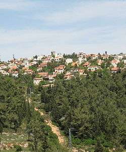
Har Adar (Hebrew: הַר אֲדָר) is an Israeli settlement and local council in the Seam Zone and the Maccabim sub-region of the West Bank. Founded in 1986,[2] it had a population of 4,058 in 2017. It is located near Abu Ghosh and the Green Line on Road 425, approximately 15 kilometers west of Jerusalem. Har Adar is ranked high on the Israeli socio-economic scale, at 9/10.[3] Har Adar was initially built adjacent to the Green Line but is now largely located within the West Bank.[4][5]
The international community considers Israeli settlements in the West Bank illegal under international law, but the Israeli government disputes this.[6]
History
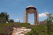
The location of Har Adar was named Radar Hill (Hebrew: גִּבְעַת הָרָדָאר, Giv'at HaRadar), for the World War II British military installation on top of the hill. The Local Jewish military thought that the installation was an anti-air radar for the protection of Jerusalem. In fact, it was a relay station, to boost the radio signal. The installation was handed over to the Jordanian Arab Legion on May 10, 1948, prior to the second phase of the 1948 Arab-Israeli War.[7] 23 attempts by the Palmach's Harel Brigade to conquer it failed,[8] although the Jewish force held the position for four days starting May 22, 1948.[7] It was finally captured in the Six-Day War by the Harel Brigade. A monument for the fallen soldiers of the brigade with Bible citation from 2 Samuel 1:19 stands at the top of the town.[8]
The current settlement was founded in 1986 initially within the Green Line. but quickly expanded over it.[9]
According to the Palestinian NGO, Applied Research Institute–Jerusalem, Israeli authorities confiscated land from two Palestinian West Bank villages for the construction of Har Adar: 456 dunams of land from Beit Surik,[10] and 36 dunums from Qatanna.[11]
On the morning of 26 September 2017, a Palestinian gunman opened fire at the checkpoint in the separation barrier at the rear of the settlement, killing one Border Police officer and two security guards, while wounding a fourth.[12]
Demographics
In 2009, the population of Har Adar was 99.3% Jewish with 1,700 men and 1,600 women.[3] The age distribution was as follows:
| Age | 0–4 | 5–9 | 10–14 | 15–19 | 20–29 | 30–44 | 45–59 | 60–64 | 65–74 | 75+ |
|---|---|---|---|---|---|---|---|---|---|---|
| Percentage | 9.6 | 10.3 | 9.8 | 8.0 | 12.4 | 20.3 | 17.6 | 6.7 | 4.4 | 0.9 |
| Source: Israel Central Bureau of Statistics[3] | ||||||||||
Economy
Har Adar is ranked 9/10 (high) on the Israeli socio-economic scale.[3] According to Business Data Israel (BDI), in 2006 Har Adar had the most stable economy of all Israeli local councils, along with Kfar Shmaryahu.[13] In 2009, the municipal surplus stood at NIS 187,000.[3]
In 2009, there were 1,471 salaried workers in Har Adar. The average salary for males was NIS 15,987, and 8,882 for women – both higher than the national average. 25.5% salaried workers worked for minimum wage. In addition, there were 143 self-employed workers, with an average income of NIS 12,311.[3]
References
- ↑ "List of localities, in Alphabetical order" (PDF). Israel Central Bureau of Statistics. Retrieved August 26, 2018.
- ↑ Uri Blau Har Adar Is Over the Green Line, but Its Residents Don't Like to Be Called Settlers Haaretz 15 March 2013
- 1 2 3 4 5 6 "Local Authorities in Israel 2009, Publication #1451 - Municipality Profiles - Har Adar" (PDF) (in Hebrew). Israel Central Bureau of Statistics. Retrieved September 8, 2011.
- ↑ Shaul Ephraim Cohen (June 1993). The Politics of Planting: Israeli-Palestinian Competition for Control of Land in the Jerusalem Periphery. University of Chicago Press. p. 158. ISBN 978-0-226-11276-3.
- ↑ Kershner, Isabel (26 September 2017). "Palestinian Gunman Kills 3 Israelis at West Bank Crossing".
- ↑ "The Geneva Convention". BBC News. 10 December 2009. Retrieved 27 September 2011.
- 1 2 Vilnai, Ze'ev (1976). "Giv'at HaRadar". Ariel Encyclopedia (in Hebrew). Volume 2. Israel: Am Oved. pp. 1165–1166.
- 1 2 HaReuveni, Immanuel (1999). Lexicon of the Land of Israel (in Hebrew). Miskal - Yedioth Ahronoth Books and Chemed Books. p. 255. ISBN 965-448-413-7.
- ↑ Cohen, Shaul Ephraim (1993). The Politics of Planting: Israeli-Palestinian Competition for Control of Land in the Jerusalem Periphery. University of Chicago Press. p. 158. ISBN 0226112764. Retrieved 26 September 2017.
- ↑ Beit Surik Town Profile, ARIJ, p. 17
- ↑ Qatanna Town Profile, ARIJ, p. 17
- ↑ Yotam Berger, Amos Harel, Jack Khoury and Nir Hasson (September 26, 2017). "Three Israelis Killed in Terrorist Attack in West Bank Settlement". Haaretz.
- ↑ "Har Adar: The Most Economically Organized Council". Emtza HaShavu'a (Jerusalem) (in Hebrew). Yedioth Ahronoth. February 26, 2008.
See also
'Israeli settler and Palestinian cooperate to save horned owl,' Ynet 23 January 2015.
External links
- Har Adar local council web site (in Hebrew)
| Cities | ||
|---|---|---|
| Regional committee | ||
| Regional councils | ||
| Local councils | ||
| See also | ||