Jornada del Muerto
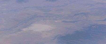
The Tularosa Basin is the lower half of the image, with the dark streak of lava north of White Sands the Carrizozo Malpais. The Trinity atomic site is northwest of the Malpais. The forested Sacramento Mountains are to the right-east.[1]
The name Jornada del Muerto is translated loosely from Spanish, historically referring to it as the "Journey of the Dead Man", though the modern literal translation is closer to "The Working Day of the Dead". As a geographic name, "Jornada del Muerto" is the desert region the Conquistadors had to cross to make it from Las Cruces to Socorro, New Mexico. As a name-place, "Jornada del Muerto" is a loose translations of "single day's journey of the dead man"[2][3] hence "route of the dead man"[4]) in the U.S. state of New Mexico was the name given by the Spanish conquistadors to the Jornada del Muerto Desert basin, and the particularly dry 100-mile (160 km) stretch of a route through it.
The trail led northward from central Spanish colonial New Spain, present-day Mexico, to the farthest reaches of the viceroyalty in northern Nuevo México Province (the area around the upper valley of the Rio Grande). The route later became a section of the Camino Real de Tierra Adentro.
Natural history
The Jornada del Muerto Desert ecoregion, in the Deserts and xeric shrublands Biome, is a wide and long stretch of flat desert landforms and xeric habitat about 100 miles (160 km) from north to south. The desert runs between the Oscura Mountains and San Andres Mountains on the east, and the Fra Cristóbal Range and Caballo Mountains on the west. The western mountains block access to the Rio Grande, the most reliable water source in the region.
The Jornada del Muerto Desert remains almost entirely uninhabited and undeveloped to the present day. Located just to the east of the southernmost region of the desert is the Jornada Basin LTER station, used for study of desert ecology, land management, plant physiology, and related topics. [5]
Volcanism
The Jornada del Muerto volcano and malpaís are located at the northern end of the desert's region and basin. The Jornada del Muerto Volcano is a shield volcano, reaching an elevation of 5,136 ft (1,565 m). The volcano's lava flow created the large Jornada del Muerto malpaís lava field, about 10 by 15 miles (16 by 24 km), over 170 square miles (440 km2) in size. The Jornada del Muerto Volcano, erupted about 760,000 years ago. It produced a slow and viscous a'a lava which has a very rough surface, making travel across it even more difficult.
Cultural history
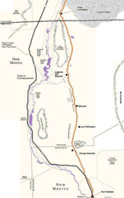
Click on Map to View
The name Journey of the Dead Man probably originated with a German man who died there while fleeing the Inquisition in the later 17th century, although due to the complete lack of water, grazing or firewood the route through this area already had a negative reputation. Although quite flat, the Jornada del Muerto took several days to a week to cross and presented great difficulties to the earliest Spanish travelers who were on foot with carts or wagons pulled by oxen.
After passing the "Jornada del Muerto" the earliest Spanish encountered, not the Seven Cities of Cíbola, but the humbler walled villages of the Pueblo dwellers, who had a well-developed agriculture and a peaceable tradition. At the first crossing the Jornada del Muerto in 1598 they named the first pueblo they came to Socorro (Spanish for 'help' or 'assistance').
In 1680, during the Pueblo Revolt the Spanish settlers were forced to retreat southward, along the Jornada del Muerto, together with Indians from the Isleta and Socorro Pueblos. Of the more than 2000 who left Socorro fewer than 1200 survived the crossing. The survivors resettled on the Rio Grande around and just south of El Paso del Norte, 'the Pass to the North', which is now separated between the Mexican city of Ciudad Juárez, Chihuahua, and the U.S. city of El Paso, Texas. In 1692, Diego de Vargas led a new group of settlers north across the Jornada del Muerto to resettle northern New Mexico.
On horseback, the Jornada could be crossed in a couple of days, as described by Bishop Tamaron traveling north on his visitation to New Mexico in 1760. Leaving the Paraje de Robledo, traveling 5 leagues:
- "On this day, the twelfth of the month and the sixth of the journey, we came to the Jornada del Muerto. To prepare for it, a detour is made to seek the river at a place called San Diego. The night is spent there. Everything necessary is made ready. It is about half a league from the river. Barrels are brought for the purpose. These are filled with water for the people. On the morning of the thirteenth the horses were taken to the river to drink. Somewhat later all the food for the journey was prepared, and at half past seven we left that post with considerable speed, stopping only to change horses. During this interval we ate what there was, and we traveled in this fashion until eight-thirty at night, when we halted opposite the Sierra of Fray Cristobal."
- "On the fourteenth day of May, the eighth day of our journey, we made an early start. We reached the river at eleven‑thirty. The livestock were so thirsty that they ran to reach the water. After this fashion were the thirty leagues of this difficult stage traveled."[6]: May 12 - 14 and Itinerary May 12-14
Homesteaders in the 1860s to 1920s tried to ranch in the Jornada del Muerto, digging wells for the cattle. The first well was at Aleman, dug by Lt. John Martin, and it appears to be the last of the homesteads to be abandoned at the end of the 20th century.
Trail
The Jornada del Muerto trail when traveling northward left the Rio Grande from the Paraje de Robledo, later the site of Fort Selden, just north of Las Cruces, New Mexico. It passed northward up through a gap, between the Selden Hills on the west and Doña Ana Mountains to the east, on to the plain of the Jornada. The last opportunity for filling water barrels and watering stock before passing farther north was from the Paraje de San Diego overlooking the Rio Grande 5 leagues beyond Robledo and a half league from the River. [6]: May 12, and Itinerary May 12
The next intermittent water was at Paraje del Perillo near where the trail passes Point of Rocks which is the southernmost point of the closed Jornada basin. The trail heads basically north through mesquite scrub land to Aleman, named for a German merchant who died of thirst there in the 1670s. There is an old homestead there now. Further north the trail crosses a number of small ephemeral lake beds the Jornada Lakes, on the way to Engle Lake then known as the Laguna del Muerto. When water was not found in the Laguna del Muerto it could be found to the west at the Ojo del Muerto, a spring in a canyon in the southern Fra Cristobal Range near the later site of Fort McRae.[7]
At the upper end of the basin the trail was squeezed between the Fra Cristóbal Range and the Jornada del Muerto lava fields. The waterless portion of the trail ends at Paraje de Fray Cristóbal on the Rio Grande, but the trail continued north along the river for 5 leagues to a paraje and fords of the Rio Grande at Valverde, across a small portion of the Jornada del Muerto Volcano lava fields, which originally reached across the Rio Grande. This large lava field, has a very rough surface, making travel across it very difficult. A rancho and small settlement at the crossing was later established at Valverde in the early 19th century, but abandoned later under the pressure of Apache attacks. Fort Conrad was established across the river and a little north of the ford of Valverde, and it was replaced by Fort Craig miles below the ford, also on the west bank.
Atomic test
On July 16, 1945 the first detonation of an atomic weapon occurred at the Trinity nuclear test site, approximately 40 miles NNE of the Jornada Del Muerto.
Arts
- Jornada del Muerto is the title of a song that appears on Linkin Park's album A Thousand Suns, which is a concept album dealing with nuclear warfare.
- Jornada del Muerto is the title of a song that appears on Nadja's album Excision.
- Events described in the novel Mount Dragon by Douglas Preston and Lincoln Child take place in a remote biological testing facility located in the Jornada del Muerto.
- A portion of the novel Flashman and the Redskins by George MacDonald Fraser takes place in the Jornada del Muerto.
- A portion of the novel Dead Man's Walk by Larry McMurtry takes place in this region.
See also
Notes
- ↑ Earth Sciences and Image Analysis, NASA-Johnson Space Center. 29 December 2003
- ↑ Wormser, Richard Edward (1966) The Yellowlegs: The Story of the United States Cavalry Doubleday, Garden City, N.Y., page 70, OCLC 952640
- ↑ Wislizenus, Frederick Adolph (1969) Memoir of a Tour to Northern Mexico: Connected with Col. Doniphan's Expedition, in 1846 and 1847 Rio Grande Press, Glorieta, NM, page 38, OCLC 51436, originally published in 1848 by the U.S. Government, Tippin & Streeper, printers, Washingtonb, D.C.
- ↑ But recently historian Fray Angélico Chávez of Santa Fe has pointed out that the Spanish name-place phrase actually means the "Route of the Dead Man." Simmons, Marc (1978) Taos to Tomé: True Tales of Hispanic New Mexico Adobe Press, Albuquerque, N.M., page 28, ISBN 0-933004-04-4
- ↑ Jornada Basin Long Term Ecological Research
- 1 2 Bishop Tamaron’s Visitation to New Mexico, 1760 from newmexicohistory.org accessed January 10, 2016
- ↑ Fort McRae by Matthew A. Sterner from newmexicohistory.org accessed December 28, 2016.
References
- "Jornada del Muerto: Retracing the Dead Man's Journey" by Douglas Preston New Mexico Magazine, September 1994, p. 24-31.
- "Jornada Del Muerto — 90 miles of hell" by Sally Bickley
- "Volcanoes of New Mexico: Jornada del Muerto Volcano". Archived from the original on 2007-09-27. Retrieved 2007-03-27.
- Crumpler, L. S., and J. C. Aubele, (1990), Jornada del Muerto, New Mexico, in Volcanoes of North America, C. A. Wood and J. Kienle. eds., Cambridge University Press, Cambridge, p. 309-310.
External links
- New Mexico Wilderness Alliance: Jornada del Muerto
- Landforms of the central Jornada del Muerto: Influencing the Path of El Camino Real de Tierra Adentro
- Hydrogeology of central Jornada del Muerto: Implications for travel along El Camino Real de Tierra Adentro, Sierra and Doña Ana Counties, New Mexico open-file report 573 June 2015, Talon Newton, Trevor Kludt, Dave Love, and Ethan Mamer
- Crossing the Jornada del Muerto: Hydrogeoogical and Geomorphological controls on traveling El Camino Real
Coordinates: 32°50′50″N 106°53′49″W / 32.84722°N 106.89694°W