Alvord Desert
| Alvord Desert | |
| Desert | |
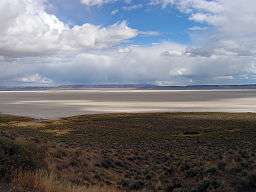 View of Alvord Desert from Steens Mountain | |
| Country | United States |
|---|---|
| State | Oregon |
| Municipality | Harney County |
| Part of | Basin and Range Province |
| Borders on | Steens Mountain(west) Mickey Butte (north) Pueblo Valley (south) Tule Springs Rim (east) |
| Location | 42°32′N 118°28′W / 42.53°N 118.46°WCoordinates: 42°32′N 118°28′W / 42.53°N 118.46°W |
| Area | 84 sq mi (218 km2) |
| Geology | Basin and Range Province |
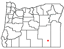 Location of the Alvord Desert within Oregon | |
The Alvord Desert is a desert located in Harney County, in southeastern Oregon in the western United States. It is roughly southeast of Steens Mountain. The Alvord Desert is a 12-by-7-mile (19 by 11 km) dry lake bed and averages 7 inches (180 mm) of rain a year. Two mountain ranges separate it from the Pacific Ocean—the Coast Range, and the Cascade Mountains. Along with Steens Mountain, these topographical features create a rain shadow. The Alvord Desert lies at an elevation of approximately 4,000 feet (1,200 m).
During the dry season the surface is flat enough to drive across or land small aircraft on. The women's world land speed record was set in 1976 by Kitty O'Neil at 512 miles/hour (843 km/hour).
The nearest community is Fields, Oregon, population 86.
Name
The desert is named after General Benjamin Alvord, who served as commander of the U.S. Army's Department of Oregon during the American Civil War.[1]
Climate
The Alvord Desert experiences a cold desert climate (Köppen BWk). The area receives very little rainfall throughout the year due to the rain shadow created by the Coast and Cascade mountain ranges as well the adjacent Steens Mountain. Some eastern areas of the desert may receive as little as 5 inches (130 mm) of rain annually.
Winter
Winter temperatures in the Alvord Basin are moderated through airflow from the south that stops the temperature from dropping too heavily. While many areas in the Oregon High Desert frequently dip below 0 °F (−18 °C) through the winter months, the Alvord Desert rarely sees these frigid temperatures. On average, highs will commonly reach between 40 and 50 °F (4 and 10 °C), with a few rare instances where the temperature fails to break 32 °F (0 °C). At night, the temperature falls to between 20 and 30 °F (−7 and −1 °C), but will not normally fall much further unless Arctic air masses arrive. The basin sees a moderate amount of its rainfall in the winter months from storms coming off the Pacific Ocean while the strong winter jet stream is aimed at the Pacific Northwest. Storms that are strong enough to bring moisture to the Southeastern area of Oregon are usually related to tropical storms feeding from the Hawaiian Islands. Snow does sometimes occur in the rare instances when cold air from the arctic to the north meets a strong flow of moisture from the Pacific to the West.
Spring
Spring is when the bulk of precipitation falls from thunderstorms. These storms attribute to the rainfall in April, May, and June that form in the south and move their way north across the desert and surrounding sagebrush plains. Clear nights continue to bring cold overnight temperatures which commonly drop to between 30 and 45 °F (−1 and 7 °C), but afternoon warming raises temperatures to between 50 and 60 °F (10 and 16 °C) in early spring and 70 and 80 °F (21 and 27 °C) in late spring. This warming can help trigger thunderstorms in combination with the unstable spring atmosphere. Extremes in temperature can still be seen at this time of year where temperatures have fallen to 0 to 10 °F (−18 to −12 °C) in March, and climbed to over 100 °F (38 °C) in early June. Rainfall turns the playa into a small lake, and for a short time, makes travel across it difficult.
Summer
Summer in the Alvord Desert has some of the hottest temperatures in the state of Oregon. High pressure sets in over the Pacific Northwest and the jet stream pushes north into Canada. This high pressure means very little precipitation, averaging less than 1 inch (2.5 cm) throughout the summer months. Late day heat begins to set in by late June where highs reach between 85 and 90 °F (29 and 32 °C). In July the temperature commonly climbs to between 90 and 100 °F (32 and 38 °C). Night-time lows vary, with overnight temperatures dropping down between 60 and 65 °F (16 and 18 °C) throughout much of the basin. In some locations temperatures will only drop to between 65 and 70 °F (18 and 21 °C). August remains hot with highs ranging between 90 and 100 °F (32 and 38 °C) and lows between 50 and 60 °F (10 and 16 °C), though dropping towards the end of the month.
Fall
Fall is moderate with high temperatures ranging between 60 and 80 °F (16 and 27 °C) and lows between 40 and 50 °F (4 and 10 °C). Fall is also one of the driest times of the year.
| Climate data for Fields, Oregon | |||||||||||||
|---|---|---|---|---|---|---|---|---|---|---|---|---|---|
| Month | Jan | Feb | Mar | Apr | May | Jun | Jul | Aug | Sep | Oct | Nov | Dec | Year |
| Record high °F (°C) | 61 (16) |
70 (21) |
78 (26) |
89 (32) |
97 (36) |
101 (38) |
106 (41) |
101 (38) |
96 (36) |
92 (33) |
76 (24) |
62 (17) |
106 (41) |
| Average high °F (°C) | 42.0 (5.6) |
45.8 (7.7) |
53.5 (11.9) |
58.8 (14.9) |
69.5 (20.8) |
79.3 (26.3) |
90.3 (32.4) |
88.1 (31.2) |
78.5 (25.8) |
64.7 (18.2) |
49.8 (9.9) |
40.9 (4.9) |
63.4 (17.4) |
| Daily mean °F (°C) | 32.4 (0.2) |
35.3 (1.8) |
41.9 (5.5) |
46.4 (8) |
55.9 (13.3) |
57.1 (13.9) |
74.7 (23.7) |
72.1 (22.3) |
62.8 (17.1) |
50.5 (10.3) |
38.7 (3.7) |
31.5 (−0.3) |
49.9 (9.9) |
| Average low °F (°C) | 22.7 (−5.2) |
24.8 (−4) |
30.3 (−0.9) |
33.9 (1.1) |
42.3 (5.7) |
49.3 (9.6) |
59.1 (15.1) |
56.1 (13.4) |
47.1 (8.4) |
36.2 (2.3) |
27.6 (−2.4) |
22.1 (−5.5) |
37.6 (3.1) |
| Record low °F (°C) | −20 (−29) |
−2 (−19) |
1 (−17) |
14 (−10) |
18 (−8) |
28 (−2) |
40 (4) |
35 (2) |
28 (−2) |
10 (−12) |
1 (−17) |
−7 (−22) |
−20 (−29) |
| Average precipitation inches (mm) | 0.80 (20.3) |
0.57 (14.5) |
0.62 (15.7) |
0.69 (17.5) |
0.86 (21.8) |
0.48 (12.2) |
0.19 (4.8) |
0.17 (4.3) |
0.31 (7.9) |
0.53 (13.5) |
0.59 (15) |
0.73 (18.5) |
6.54 (166.1) |
| Source: Western Regional Climate Center[2] | |||||||||||||
Geology
Three primary geothermal areas are along the western edge[3] as well as cold springs following NE to SW trending normal faults. On the western edge of the desert is Alvord Hot Springs (42°32′38″N 118°32′02″W / 42.5440°N 118.5340°W). At the north is Mickey Hot Springs (42°40′41″N 118°20′48″W / 42.6781°N 118.3467°W): an assortment of bubbling mud, pools and, occasional geyser. At the south is Borax Lake (42°19′37″N 118°36′10″W / 42.3269°N 118.6028°W) which is a thermal spring complex. To the east is an unnamed natural hot spring, one of 40 or more along 25 miles (40 km) of the Alvord fault. To the southwest is seasonal alkali Alvord Lake which once extended 100 miles (160 km) north and south—covering the desert. Several of the geothermal features in Alvord Desert Basin have been examined by a team of scientists and geologists[4] from the University of Idaho, Boise State University, and Idaho State University.[5]
Fauna
Despite the barren nature of the playa, some opportunities for wildlife observation exist. Wild horses sometimes drink from the springs on the eastern edge of the desert. In areas where natural hot springs flow into the playa, especially around the Alvord Hot Springs, one can usually find nesting long-billed curlew. Further out into the playa proper are numerous killdeer and snowy plover, along with the occasional American avocet. The outlet waters from the springs typically flow roughly one mile into the desert, and their reach roughly delineates the bird habitat. The nearby Steens Mountain Wilderness contains populations of bighorn sheep, mule deer, elk, and pronghorn. Further west is the Malheur National Wildlife Refuge, which is popular for birding.
Land speed record
The current women's Land Speed Record was set at Alvord Desert by Kitty O'Neil, in the jet-powered SMI Motivator, in 1976.[6] O'Neil reached 512.710 mph (825.127 km/h).[7][8][9]
Gallery
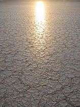 Setting sun reflected off the playa
- Alvord Desert as seen from the west
 Steens Mountain to the northwest from the Alvord Desert
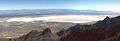 Alvord Desert playa, viewed from Steens Mountain
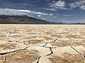 Close-up of the surface, June 2018
References
- ↑ Corning, Howard M. Dictionary of Oregon History. Binfords & Mort Publishing, 1956.
- ↑ "Fields, Oregon". Western Regional Climate Center. Desert Research Institute. Retrieved September 28, 2013.
- ↑ Angie Koski; Scott Wood (November 5, 2003). "Aqueous Geochemistry of Thermal Waters in the Alvord Basin, Oregon". University of Idaho, Moscow. Retrieved 2012-11-29.
- ↑ Hinds, J. "Alvord Hot Springs". Life at Interfaces: Biocomplexity in Extreme Environments. The Experimental Project to Stimulate Competitive Research. Archived from the original on 2007-10-08. Retrieved 2008-03-06.
- ↑ Michael L. Cummings (July 14, 2000). "Extent and location of the geothermal aquifer in the Alvord Basin, Harney County, Oregon: A study based on Strontium Isotope Geochemistry of rocks and fluids". Archived from the original on February 26, 2001. Retrieved 2012-11-29.
- ↑ Ellen Jares, Sue. "The Renaissance Woman of Danger—That's Tiny Kitty O'Neil". People. Retrieved 7 January 2014.
- ↑ Phinizy, Coles. "A Rocket Ride To Glory And Gloom". SI Vault. Retrieved 7 January 2014.
- ↑ "Deaf stuntwoman Kitty O'Neil sets women's land-speed record". History. Retrieved 7 January 2014.
- ↑ "Thrust SSC: Rockets Rule". Archived from the original on 7 March 2008. Retrieved 2008-03-16.
External links
| Wikimedia Commons has media related to Alvord Desert. |
- Alvord Desert - Bureau of Land Management
- Bishop, Ellen. "Alvord Desert". The Oregon Encyclopedia.
- The Wilderness Society: Wilderness in Oregon’s High Desert
- Alvord Desert Gliders Video produced by Oregon Field Guide