Jiali District
Coordinates: 23°10′0.8″N 120°10′42.5″E / 23.166889°N 120.178472°E
| Jiali 佳里區 | |
|---|---|
| District | |
 | |
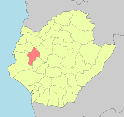 Jiali District in Tainan City | |
| Location | Tainan, Taiwan |
| Area | |
| • Total | 39 km2 (15 sq mi) |
| Population (July 2018) | |
| • Total | 59,230 |
| • Density | 1,500/km2 (3,900/sq mi) |
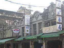
Jiali District (Chinese: 佳里區; pinyin: Jiālǐ Qū; Wade–Giles: Chia1-li3 Ch'ü1; Pe̍h-ōe-jī: Ka-lí) is a district located in Tainan, Taiwan, about 15 km north of the former Dutch base of Fort Zeelandia.
History
In the 17th century, the place was named Soulang after one of the four subtribes of the local Siraya aborigines. Soulang was a village of about 1,500 inhabitants about 15 kilometres (9.3 mi) north of Fort Zeelandia,[1] and became a station of the Dutch East India Company. It later became the Chinese market-town called Siau-lang[2] (Chinese: 蕭瓏 / 蕭隴 / 蕭壟; Pe̍h-ōe-jī: Siau-lang / Siau-lâng).[3]
Education
Tourist attractions
- Soulangh Cultural Park
- Jintang Temple
- Zhengxing Temple[4]
- Beitouyang Cultural Park
Transportation
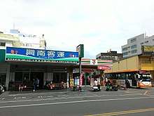
Jiali Bus Station
- Jiali Bus Station
See also
References
- ↑ Andrade, Tonio (2005). "Chapter 3: Pax Hollandica". How Taiwan Became Chinese: Dutch, Spanish, and Han Colonization in the Seventeenth Century. Columbia University Press. §1-3.
- ↑ Campbell, William (1903). "Explanatory Notes". Formosa under the Dutch: described from contemporary records, with explanatory notes and a bibliography of the island. London: Kegan Paul. p. 547. OCLC 644323041.
- ↑ "Entry #40235 (蕭壟)". 臺灣閩南語常用詞辭典 [Dictionary of Frequently-Used Taiwan Minnan] (in Chinese and Hokkien). Ministry of Education, R.O.C. 2011.
- ↑ http://web1.tainan.gov.tw/NewEnglish/CP/12376/Jiali-1.aspx
External links
| Wikimedia Commons has media related to Jiali District, Tainan. |
| Districts | .svg.png) | |
|---|---|---|
Note: Although Hanyu Pinyin is the national standard, Tainan names most of its districts by Tongyong Pinyin. East, South, West Central, and North district uses English instead. | ||
This article is issued from
Wikipedia.
The text is licensed under Creative Commons - Attribution - Sharealike.
Additional terms may apply for the media files.