Issyk-Kul Region
| Issyk-Kul Region Ысык-Көл областы Иссык-Кульская область | |||
|---|---|---|---|
| Region | |||
| |||
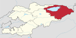 Map of Kyrgyzstan, location of Issyk-Kul Region highlighted, with Lake Issyk-Kul in blue | |||
| Coordinates: 42°0′N 78°0′E / 42.000°N 78.000°ECoordinates: 42°0′N 78°0′E / 42.000°N 78.000°E | |||
| Country |
| ||
| Capital | Karakol | ||
| Government | |||
| • Gubernator | Mirbek Asanakunov | ||
| Area | |||
| • Total | 43,100 km2 (16,600 sq mi) | ||
| Population (2015) | |||
| • Total | 463,900 | ||
| • Density | 11/km2 (28/sq mi) | ||
| Time zone | UTC+6 (East) | ||
| • Summer (DST) | UTC+6 (not observed) | ||
| ISO 3166 code | KG-Y | ||
| Districts | 5 | ||
| Cities | 3 | ||
| Townships | 5 | ||
| Villages | 175 | ||


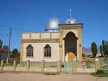
Issyk-Kul Region (Kyrgyz: Ысык-Көл облусу, Isıq-Köl oblusu, ىسىق-كۅل وبلاستى; Russian: Иссык-Кульская область, Issyk-Kuljskaja oblastj) is one of the regions of Kyrgyzstan. Its capital is Karakol. It is surrounded by Almaty Region, Kazakhstan (north), Chuy Region (west), Naryn Region (southwest) and Xinjiang, China (southeast). It takes its name from Lake Issyk-Kul ("warm lake"), the second largest saline lake in the world, which never freezes despite its altitude in the Tian Shan mountains.
Geography
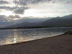
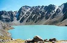
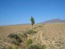
The north is dominated by the eye-shaped Issyk-Kul lake, surrounded by the ridges of the Tian Shan mountain system: the Kyungey Ala-Too mountains to the north and the Terskey Alatau to the south (the 'sunny' and 'shady' Alatau, respectively). To the south is mountains and 'jailoos' (mountain meadows used for summer grazing). The highest peaks of the Tian Shan mountains, including Khan Tengri, are located in the easternmost part of the region.
Most of the population of the region lives around the lake, in particular in the cities of Balykchy near the lake's western end, and Karakol near its eastern end.
Basic socio-economic indicators
- Population: 463,900 (assessment for 1 January 2015) including 130,800 urban and 333,100 rural population[1]
- Employed population: 180,300 (2008)[2]
- Registered unemployed population: 4,902 (2008)[3]
- Export: 18.8 million US dollars (2008)[4]
- Import: 221.7 million US dollars (2008)[4]
- Direct Foreign Investments: 1,1 million US dollars (in 2008)[5]
Demographics
As of 2009, Issyk-Kul Region included three towns, five urban-type settlements, and 175 villages. Its de facto and permanent population, according to the Population and Housing Census of 2009, was 425,116 and 438,389 correspondingly.
| Historical populations in Issyk-Kul Region | ||
|---|---|---|
| Year | Pop. | ±% |
| 1970 | 311,992 | — |
| 1979 | 352,017 | +12.8% |
| 1989 | 409,618 | +16.4% |
| 1999 | 415,513 | +1.4% |
| 2009 | 425,116 | +2.3% |
| Note: de facto population; Source:[6] | ||
Ethnic composition
According to the 2009 Census, the ethnic composition (de jure population) of Issyk-Kul Region was:[6]
| Ethnic group | Population | Proportion of Issyk-Kul Region population |
|---|---|---|
| Kyrgyzs | 377,994 | 86.2% |
| Russians | 35,275 | 8.0% |
| Kazakhs | 6,464 | 1.5% |
| Uygurs | 3,897 | 0.9% |
| Kalmyks | 3,801 | 0.9% |
| Dungans | 3,124 | 0.7% |
| Uzbeks | 2,982 | 0.7% |
| Tatars | 2,098 | 0.5% |
| Ukrainians | 1,170 | 0.3% |
| other groups | 1,584 | 0.3% |
Transportation
The railroad coming from the northwest (from Bishkek) ends at Balykchy. The main highway (A365) from Bishkek passes through Balykchy and into the Naryn Region on its way to the Torugart Pass into China. Highway A363 circles the lake and A362 runs east from the lake into Kazakhstan. Issyk-Kul International Airport and Karakol International Airport link the region with Almaty in Kazakhstan. Cholpon-Ata Airport and Tamga Airport have no regular flights.
Tourism
The region, which resembles the Alps or Colorado, would be a major tourist destination were it not for its remoteness, underdeveloped infrastructure, and growing conflict between Kyrgyz nationalists and independence factions, which in December 2008 flared up again, killing 39 civilians. Currently, it is visited mostly by locals who use the Soviet-era establishments around the lake and the more adventurous sort of international tourist.
Districts
Issyk-Kul is divided administratively into five districts:[7]
| District | Capital | Map |
|---|---|---|
| Ak-Suu District | Karakol | 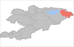 |
| Jeti-Ögüz District | Kyzyl-Suu | 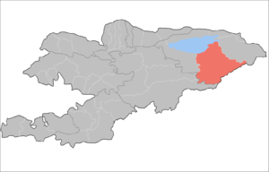 |
| Tong District | Bokonbaev | 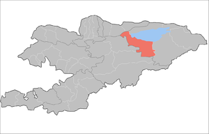 |
| Tüp District | Tüp | 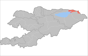 |
| Issyk-Kul District | Cholpon-Ata | 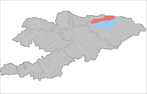 |
References
- ↑ "Численность населения областей, районов, городов и поселков городского типа Кыргызской Республики в 2015 г." [Population of regions, districts, cities and towns of the Kyrgyz Republic in 2015] (PDF). National Committee on Statistics. Retrieved 5 December 2015.
- ↑ National Committee on Statistics (in Kyrgyz/Russian) Archived 2010-11-14 at the Wayback Machine.
- ↑ National Committee on Statistics (in Kyrgyz/Russian) Archived 2010-11-14 at the Wayback Machine.
- 1 2 National Committee on Statistics (in Kyrgyz/Russian) Archived 2011-07-22 at the Wayback Machine.
- ↑ National Committee on Statistics (in Kyrgyz/Russian) Archived 2011-07-22 at the Wayback Machine.
- 1 2 "2009 population census of the Kyrgyz Republic: Issyk-Kul Region" (PDF). Archived from the original on 10 August 2011. Retrieved 2017-01-04.
- ↑ Kyrgyzstan – Джалал-Абадская область Archived 2009-08-02 at the Wayback Machine.
- Laurence Mitchell, Kyrgyzstan, Bradt Travel Guides, 2008
External links
| Wikimedia Commons has media related to Issyk-Kul Province. |
- Guide to the region from the Spektator magazine
- (in English) Karakol – Djeti-Oguz region in Central Tien-Shan (Mountaineering reports and maps. Although the site is in English, with some web browsers you may need to set "Character Encoding" to "Cyrillic" in the "View" menu of your browser in order to get better display of the main page).
Places adjacent to Issyk-Kul Region | ||||||||||
|---|---|---|---|---|---|---|---|---|---|---|
| ||||||||||