Ala-Kul
| Ala-Kul | |
|---|---|
 | |
| Location | Terskey Alatau |
| Coordinates | 42°19′3″N 78°32′8″E / 42.31750°N 78.53556°ECoordinates: 42°19′3″N 78°32′8″E / 42.31750°N 78.53556°E |
| Lake type | Rock-dammed |
| Catchment area | 9.46 km2 (3.65 sq mi) |
| Basin countries | Kyrgyzstan |
| Max. length | 2.3 km (1.4 mi) |
| Max. width | 0.7 km (0.43 mi) |
| Surface elevation | 3,560 m (11,680 ft) |
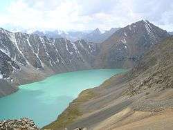
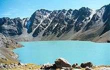
Ala Köl, also Ala-Kul, (Kyrgyz: Алакөл) is a rock-dammed lake in the Terskey Alatau mountain range in the Ak-Suu District of Issyk-Kul Region of Kyrgyzstan. It lies at an altitude of approximately 3560 meters.
History
Lake Ala-Kul
A Russian traveller named Putimtsoff was the first to visit the lake in 1811. He gave a good description of it, mentioning rocks of different colours in the lake, and the furious winds blowing around the lake. Thirty years later Alexander Schrenk explored the lake and its surroundings.[1]
Literally, the name Ala-kul would mean 'variegated lake,' although it probably takes its name from the Ala-Таu mountains lying further north.[2]
See also
References
- ↑ Bretschneider, E. (1910), Mediæval researches from eastern Asiatic sources: Fragments towards the knowledge of the geography and history of central and western Asia from the 13th to the 17th century, p. 126, Michigan University
- ↑ Taylor, Issac (1898), Names and their histories: a handbook of historical geography and topographical nomenclature, p. 317, Rivingtons
External links

|
This article is issued from
Wikipedia.
The text is licensed under Creative Commons - Attribution - Sharealike.
Additional terms may apply for the media files.