Iruma River
| Iruma River | |
|---|---|
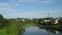 Iruma River in Hannō, Saitama | |
| Native name | Japanese: 入間川 |
| Country | Japan |
| Physical characteristics | |
| Main source |
Mount Hannō in Hannō, Saitama 1,197 m (3,927 ft) |
| River mouth | Arakawa River |
| Length | 63 km (39 mi) |
| Basin features | |
| Basin size | 721 km2 (278 sq mi) |
The Iruma River (入間川 Iruma-gawa), is a river in Saitama Prefecture, Japan. It is 63 kilometres (39 mi) long and has a watershed of 721 square kilometres (278 sq mi). The river rises from Mount Ōmochi in Hannō, Saitama and flows to the Arakawa River at Kawagoe, Saitama.
References
External links
35°54′35″N 139°32′43″E / 35.90982°N 139.545139°ECoordinates: 35°54′35″N 139°32′43″E / 35.90982°N 139.545139°E (mouth, flows into Arakawa River)
| |||||||||||||||||
| |||||||||||||||||
| |||||||||||||||||
| |||||||||||||||||
| |||||||||||||||||
This article is issued from
Wikipedia.
The text is licensed under Creative Commons - Attribution - Sharealike.
Additional terms may apply for the media files.