Hoy
| Norse name | Há-øy[1] |
|---|---|
| Meaning of name | Old Norse for 'high island'[1] |
 The Old Man of Hoy, at the western side of the island, seen from the south | |
| Location | |
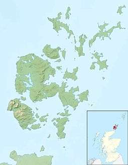 Hoy Hoy shown within Orkney | |
| OS grid reference | ND263961 |
| Coordinates | 58°50′N 3°18′W / 58.83°N 3.3°W |
| Physical geography | |
| Island group | Orkney |
| Area | 14,318 hectares (55.3 sq mi)[1] |
| Area rank | 12 [2] |
| Highest elevation | Ward Hill 479 metres (1,572 ft) |
| Administration | |
| Sovereign state | United Kingdom |
| Country | Scotland |
| Council area | Orkney Islands |
| Demographics | |
| Population | 419[3][Note 1] |
| Population rank | 23 [2] |
| Population density | 2.9 people/km2[1][3] |
| Largest settlement | Lyness |
| References | [6][7] |
Hoy (from Norse Háey meaning "high island") is an island in Orkney, Scotland, measuring 143 square kilometres (55 sq mi) — ranked largest in the archipelago after Mainland. A natural causeway, the Ayre, links to much smaller South Walls; the two islands are treated as one entity by the UK census.[3][8]
Description
The dramatic coastline of Hoy greets visitors travelling to Orkney by ferry from the Scottish mainland. It has extremes of many kinds: some of the highest sea cliffs in the UK at St John's Head, which reach 350 metres (1,150 ft);[1]; a light-stone precarious sea stack taller than the facing cliff – the Old Man of Hoy; patches of northernmost scattered, hardy woodland and the remote possibility of locally extant Orkney charr (Salvelinus inframundus) documented in 1908 at Heldale Water.[9] The two most northerly Martello Towers stand here, built to defend the south entrance to Scapa Flow at Longhope in 1814 towards the end of the Napoleonic War; they have never been used in combat.
The highest point in the archipelago, Ward Hill, is on Hoy.
The main naval base for the British fleet in both the First and Second World Wars, Scapa Flow, was at Lyness in the southeast of the island. Some rather incongruous Art Deco structures nearby date from this period. The Arts and Crafts architect William Lethaby rebuilt Melsetter house for mountaineer Thomas Middlemore at the end of the nineteenth century leaving untouched the adjacent barn which is probably mid-18th century.[10][11]

An unusual rock-cut tomb, the Dwarfie Stane, lies in the Rackwick valley towards the north. It is unique in northern Europe, bearing similarity to Neolithic or Bronze Age tombs around the Mediterranean. The tomb has a small rectangular entrance and cleft, hence its name.[Note 2]
Orkney Ferries traverse the west of Scapa Flow with two routes:
- Lyness on Hoy and Longhope on associated Walls via small Flotta to/from the village of Houton on Orkney Mainland.
- Moaness in Hoy via small Graemsay to/from the town of Stromness on Orkney Mainland.
Hoy is part of the Hoy and West Mainland National Scenic Area, one of 40 in Scotland.[12]
Mythology
In Norse mythology, Hoy hosted Hjaðningavíg, the never-ending battle between Heðin and Högni.
Wildlife
Hoy is an Important Bird Area.[13][14] The northern part of the island is an RSPB reserve due to its importance for birdlife, particularly great skuas and red-throated divers. It was sold to the RSPB by the Hoy Trust for a nominal amount.[15] Anastrepta orcadensis, a liverwort also known as Orkney Notchwort, was first discovered on Ward Hill by William Jackson Hooker in 1808.[16][17]
The northern and western parts of Hoy, along with much of the adjoining sea area, is designated as a Special Protection Area[18] due to its importance for nine breeding bird species: arctic skua, fulmar, great black-backed gull, great skua, guillemot, Black-legged kittiwake, peregrine falcon, puffin and red-throated diver.[19] The area is important for its seabird assemblage, which regularly supports 120,000 individual seabirds during the breeding season.[20]
In popular culture
Hoy is featured prominently in the 1984 video for "Here Comes The Rain Again" by Eurythmics.
Gallery
 Cliffs on the Atlantic coast of Hoy, south of Rackwick
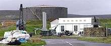 Scapa Flow Visitor Centre
 Hoy High Lighthouse on Graemsay, viewed from Mainland
 Rackwick Valley
 Rackwick
Notes
- ↑ Including South Walls.
- ↑ Dwarfie/dwarfy is an adjective of a slightly deprecated term for any small grown human, dwarf; stane is the word stone before the Great English Vowel Shift as in most Roman roads locally or collectively recorded as "stane streets".
References
- 1 2 3 4 5 6 Haswell-Smith, Hamish (2004). The Scottish Islands. Edinburgh: Canongate. pp. 344–6. ISBN 978-1-84195-454-7.
- 1 2 Area and population ranks: there are c. 300 islands over 20 ha in extent and 93 permanently inhabited islands were listed in the 2011 census.
- 1 2 3 National Records of Scotland (15 August 2013) (pdf) Statistical Bulletin: 2011 Census: First Results on Population and Household Estimates for Scotland - Release 1C (Part Two). "Appendix 2: Population and households on Scotland’s inhabited islands". Retrieved 17 August 2013.
- ↑ Orkney Placenames. Orkneyjar.
- ↑ Ordnance Survey: Landranger map sheet 6 Orkney (Mainland) (Map). Ordnance Survey. 2014. ISBN 9780319228128.
- ↑ Anderson, Joseph (Ed.) (1893) Orkneyinga Saga. Translated by Jón A. Hjaltalin & Gilbert Goudie. Edinburgh. James Thin and Mercat Press (1990 reprint). ISBN 0-901824-25-9
- ↑ Pedersen, Roy (January 1992) Orkneyjar ok Katanes (map, Inverness, Nevis Print)
- ↑ General Register Office for Scotland (28 November 2003) Scotland's Census 2001 – Occasional Paper No 10: Statistics for Inhabited Islands. Retrieved 26 February 2012.
- ↑ IUCN Red List
- ↑ Tinniswood, Adrian (1999). The Arts & Crafts House. New York: Watson-Guptill Publications. pp. 34–37. ISBN 0-8230-0364-7.
- ↑ "Listed Building Report – Walls and Flotta Parish – Walls (Hoy), Melsetter, the Hall, Including Gatepiers to West". Crown copyright, Historic Scotland. 8 December 1971. Retrieved 8 January 2013.
- ↑ National Scenic Areas Archived 11 March 2017 at the Wayback Machine.. SNH. Retrieved 30 March 2011
- ↑ Important Bird Areas factsheet: Hoy Birdlife.org, Retrieved 24 January 2015
- ↑ Hoy IBA Global Species.org, Retrieved 24 January 2015
- ↑ Haswell-Smith, Hamish (1996). The Scottish Islands. Canongate. p. 283. ISBN 0-86241-579-9.
- ↑ "Bryology (mosses, liverworts and hornworts)" Royal Botanic Garden Edinburgh. Retrieved 15 May 2008.
- ↑ "West Highland Mosses And Problems They Suggest" (January 1907) Annals Of Scottish Natural History 61 p. 46. Edinburgh. Retrieved 11 June 2008.
- ↑ "Sitelink - Map Search". Scottish Natural Heritage. Retrieved 2018-01-24.
- ↑ "Site Details for Hoy (SPA)". Scottish Natural Heritage. 2018-03-05. Retrieved 2018-03-21.
- ↑ "SPA Description (Hoy)". Joint Nature Conservation Committee. 2005-07-21. Retrieved 2018-03-21.
External links
| Wikimedia Commons has media related to Hoy. |
| Wikivoyage has a travel guide for Hoy. |
Coordinates: 58°51′N 3°18′W / 58.850°N 3.300°W
|  | ||||||||||||||||
|
| |||||||||||||||||
| |||||||||||||||||
| |||||||||||||||||
| |||||||||||||||||
| |||||||||||||||||
| |||||||||||||||||
| |||||||||||||||||