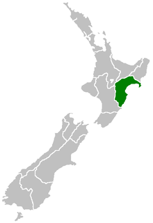
Hawke's Bay Region
Coordinates: 39°25′S 176°49′E / 39.417°S 176.817°E
| Hawke's Bay | |
| Country: | New Zealand |
 | |
| Regional council | |
|---|---|
| Name: | Hawke's Bay Regional Council |
| Seat: | Napier |
| Largest city: | Hastings |
| Population: | 164,000 June 2017 [1] |
| Land area: | 14,111 km² |
| Chair: | Rex Graham |
| Deputy chair: | Rick Barker |
| Website: | http://www.hbrc.govt.nz/ |
| Cities and towns | |
| Cities: | Hastings • Napier |
| Towns and other settlements: | Bridge Pa • Clive • Frasertown • Haumoana • Mahia Beach • Maraekakaho • Nuhaka • Ocean Beach • Ongaonga • Otane • Takapau • Te Awanga • Tikokino • Tuai • Tutira • Waimarama • Waipawa • Waipukurau • Wairoa |
| Territorial authorities | |
| Names: | Central Hawke's Bay Hastings District Napier City Wairoa District Rangitikei District (part) Taupo District (part) |
| Geographic figures | |
| Land area: | 14,111 km² |
| Coastline: | 360 km |
| Highest point: | Mount Mangaweka 1,733m |
| Longest river: | Mohaka River 174 km |
| Largest lake: | Lake Waikaremoana 54 km² |
Hawke's Bay Region (Māori: Te Matau-a-Māui[2]) is a region of New Zealand on the east coast of the North Island. It is recognised on the world stage for its award-winning wines. Hawke's Bay Regional Council sits in the city of Napier. It derives from Hawke Bay which was named by Captain James Cook in honour of Admiral Edward Hawke who decisively defeated the French at the Battle of Quiberon Bay in 1759.
Geography
The region is situated on the east coast of the North Island. It bears the former name of what is now Hawke Bay, a large semi-circular bay that extends for 100 kilometres from northeast to southwest from Mahia Peninsula to Cape Kidnappers.
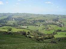
The Hawke's Bay region includes the hilly coastal land around the northern and central bay, the floodplains of the Wairoa River in the north, the wide fertile Heretaunga Plains around Hastings in the south, and a hilly interior stretching up into the Kaweka and Ruahine Ranges.
Five major rivers flow down into the coast of Hawke's Bay. From north to south, they are the Wairoa River, Mohaka River, Tutaekuri River, Ngaruroro River and Tukituki River respectively. Lake Waikaremoana is situated in northern Hawke's Bay roughly 35 km from the coast. It is the largest lake in Hawke's Bay, 4th largest in the North Island and 16th largest in New Zealand.
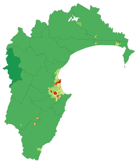
The region consists of Wairoa District, Hastings District, Napier City, and its southernmost district, Central Hawke's Bay District, as well as the town of Taharua in Taupo District and the town of Ngamatea in Rangitikei District. It does not include the Tararua District, Dannevirke and Woodville or Norsewood, came under the Manawatu-Wanganui Regional Council (also known as Horizons Regional Council) in the 1989 local government reforms.[3][4]
In June 2015, the Local Government Commission proposed the amalgamation of the four local councils with the Hawke's Bay Regional Council.[5] This proposal was rejected by the affected communities.[6]
The region has a hill with the longest place name in New Zealand, and the longest in the world according to the 2009 Guinness Book of Records. Taumatawhakatangihangakoauauotamateaturipukakapikimaungahoronukupokaiwhenuakitanatahu is an otherwise unremarkable hill in southern Hawke's Bay, not far from Waipukurau.
Demography
The region's population is 164,000 as of June 2017, 3.4 percent of New Zealand's population.[1] Around 81 percent of the region's population lives in the Napier-Hastings conurbation.
Below is a list of urban areas that contain more than 1,000 population.
| Urban area | Population (June 2017)[1] |
% of region |
|---|---|---|
| Hastings | 79,900 | 48.7% |
| Napier | 62,000 | 37.8% |
| Wairoa | 4,280 | 2.6% |
| Waipukurau | 4,140 | 2.5% |
| Waipawa | 2,100 | 1.3% |
Culture and identity
The region has a significant Māori population; 24.3 percent of the population identified as of Māori ethnicity at the 2013 census.[7] A major local Māori tribe is Ngāti Kahungunu.
Around 50.5 percent of Hawke's Bay's population affiliate with Christianity at the 2013 Census, making it one of two regions in New Zealand (the other being Southland) with a majority Christian population.[8]
| Ethnicity | Number | % |
|---|---|---|
| European | 110,940 | 77.7 |
| New Zealand European | 104,250 | 73.0 |
| English | 1,320 | 0.9 |
| British | 1,077 | 0.8 |
| Dutch | 972 | 0.7 |
| Māori | 34,659 | 24.3 |
| Pacific peoples | 6,270 | 4.4 |
| Samoan | 2,859 | 2.0 |
| Cook Islands Maori | 2,283 | 1.6 |
| Asian | 5,118 | 3.6 |
| Indian | 1,974 | 1.4 |
| Chinese | 1,422 | 1.0 |
| Middle Eastern/Latin American/African | 666 | 0.5 |
| Other | 2,766 | 1.9 |
| New Zealander | 2,709 | 1.9 |
| Total people stated | 142,845 | 100.0 |
| Not elsewhere included | 8,334 | 5.5 |
History
Hawke's Bay Province was founded in 1858 as a province of New Zealand, after being separated from the Wellington Province following a meeting in Napier in February 1858. The Province was abolished in 1876 along with all other provinces in New Zealand. It was replaced with a Provincial District.
On February 3, 1931, Napier and Hastings were devastated by New Zealand's worst natural disaster, an earthquake measuring 7.9 on the Richter magnitude scale, which killed 256 people. Napier rebuilt and now the city is world-famous for its Art Deco buildings, and celebrates its heritage each February with the Art Deco Weekend. MTG Hawke's Bay, formerly Hawke's Bay Museum and Art Gallery, has an exhibition on the earthquake, its causes and impact.
Economy
The GDP of the Hawke's Bay region was estimated at $7.4 billion as of March 2017, 3% of the national GDP.[10]
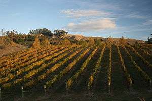
The region is renowned for its horticulture, with large orchards and vineyards on the plains. In the hilly parts of the region sheep and cattle farming predominates, with forestry blocks in the roughest areas.
The climate is dry and temperate, and the long, hot summers and cool winters offer excellent weather for growing grapes. Missionaries in the mid 19th century planted the first vines in Hawke's Bay and it is now becoming an important place for full bodied red wines.[11] As of January 2010, there are an estimated 75 wineries located across Hawke's Bay.[12] https://www.nzherald.co.nz/the-country/news/article.cfm?c_id=16&objectid=12020171 Hawke's Bay is home to New Zealand's first space launch complex, Rocket Lab's orbital launch site (known as Launch Complex 1) on the Māhia Peninsula in Wairoa District. Wairoa District is home to 'Space Coast New Zealand' - that stretch of Wairoa district's coastline from which space launch viewing can be undertaken. Rocket Lab anticipates launching its 17m Electron vehicle early in 2017.
Seismicity
Hawke's Bay is one of the most seismically active regions in New Zealand and has experienced many large and often damaging earthquakes. More than 50 damaging earthquakes have rocked the region since the 1800s. Some of the more notable are listed below.
| Date | Location | Magnitude (ML) | Depth | Fatalities | More information |
|---|---|---|---|---|---|
| 8 Jul 1843 | 25 km west of Tikokino | 7.6 | 12 km | 2 | [13] |
| 22 Feb 1863 | Waipukurau | 7.5 | 25 km | 1863 Hawke's Bay earthquake [14] | |
| 14 Sep 1875 | Mahia Peninsula | 5.8 | 25 km | [15] | |
| 9 Aug 1904 | Porangahau | 7.0 | 16 km | [16] | |
| 28 Jun 1921 | Kaweka Forest Park | 6.7 | 80 km | [17] | |
| 12 Feb 1930 | Porangahau | 6.2 | 33 km | [18] | |
| 3 Feb 1931 | 20 km north of Napier | 7.8 | 20 km | 256 | 1931 Hawke's Bay earthquake [19] |
| 3 Feb 1931 | 25 km north east of Napier | 5.8 | 25 km | [20] | |
| 8 Feb 1931 | Wairoa | 6.4 | 60 km | [21] | |
| 13 Feb 1931 | 50 km east of Napier | 7.3 | 30 km | [22] | |
| 5 May 1932 | 50 km east of Napier | 5.9 | 12 km | [23] | |
| 16 Sep 1932 | Wairoa | 6.9 | 12 km | [24] | |
| 5 Mar 1934 | Pongaroa | 7.2 | 12 km | [25] | |
| 15 Mar 1934 | Wairoa | 6.3 | 25 km | [26] | |
| 26 Feb 1940 | Hastings | 6.0 | 25 km | [27] | |
| 1 Mar 1950 | Lake Waikaremoana | 5.8 | 60 km | [28] | |
| 10 Feb 1951 | Porangahau | 6.2 | 33 km | [29] | |
| 6 Oct 1980 | Hastings | 5.7 | 30 km | [30] | |
| 19 Feb 1990 | Porangahau | 6.2 | 34 km | [31] | |
| 13 May 1990 | Porangahau | 6.4 | 30 km | [32] |
Council
The Hawke's Bay regional council consists of nine elected members and holds elections every three years. As of the 2016 election the current council is:
| Member(s) | Constituency |
|---|---|
| Rex Graham - Chair | Hastings |
| Rick Barker - Deputy Chair | Hastings |
| Alan Dick | Napier |
| Tom Belford | Hastings |
| Fenton Wilson | Wairoa |
| Debbie Hewitt | Central Hawke's Bay |
| Peter Beaven | Ngaruroro |
| Neil Kirton | Napier |
| Paul Bailey | Napier |
Culture
The region is served by a variety of radio stations including Radio Kahungunu, The Hits 89.5, More FM, access station Radio Kidnappers and local station Bay FM. As well, most of the national commercial and non-commercial operators have transmitters covering the region. Hawke's Bay also has its own TV station, TVHB, which provides a mix of news and information programmes hosted by local personalities.
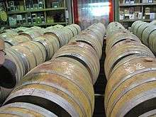
Hawke's Bay produces some of New Zealand's finest wines and once a year Harvest Hawke's Bay celebrates the fact by offering a three-day wine and food festival. This event attracts many thousands.
Napier is home to the Mission Concert held early each year since 1993. The event, held at the Mission Estate Winery in Taradale, has attracted performers such as Kenny Rogers, Shirley Bassey, Rod Stewart, The B-52's, Belinda Carlisle, Ray Charles, and Eric Clapton. The 2009 concert attraction was to be Lionel Richie, but the concert was cancelled because of rain.
Sport
As throughout New Zealand, Rugby union is the most popular sport. The Hawke's Bay Magpies play in New Zealand's annual professional domestic rugby union competition, the Mitre 10 Cup. The team represents the Hawke's Bay region in provincial representative rugby, and draws its players from the constituent clubs who are affiliated to the provincial union. The team play their home matches in McLean Park in Napier. Players representing Hawke's Bay are also eligible to play for the Hurricanes in the annual transnational Super Rugby competition. Hawke's Bay has produced a number of notable All Blacks, including Cyril Brownlie, Maurice Brownlie, Mark Donaldson, and more recently, Bryn Evans, Greg Somerville, Hikawera Elliot, Zac Guildford and current All Black Israel Dagg. The Hawke's Bay Hawks compete in the New Zealand National Basketball League.
References
- 1 2 3 "Subnational Population Estimates: At 30 June 2017 (provisional)". Statistics New Zealand. 24 October 2017. Retrieved 24 October 2017. For urban areas, "Subnational population estimates (UA, AU), by age and sex, at 30 June 1996, 2001, 2006-16 (2017 boundary)". Statistics New Zealand. 24 October 2017. Retrieved 24 October 2017.
- ↑ Kerryn Pollock, 'Hawke’s Bay region - Overview', Te Ara - the Encyclopedia of New Zealand, http://www.TeAra.govt.nz/en/hawkes-bay-region/page-1 (accessed 9 November 2017)
- ↑ Pollock, Kerryn (15 November 2012). "Hawke's Bay region – Local government boundary changes". Te Ara – the Encyclopedia of New Zealand.
- ↑ Pollock, Kerryn (15 November 2012). "Hawke's Bay region – Government, education and health". Te Ara – the Encyclopedia of New Zealand.
- ↑ Lunn, Annette (9 June 2015). "Hawke's Bay to amalgamate councils". Newstalk ZB.
- ↑ Henderey, Simon (15 September 2015). "Hawke's Bay voters reject five-council amalgamation proposal". The Dominion Post.
- ↑ "2013 Census QuickStats about culture and identity – data tables". Statistics New Zealand. 15 April 2014. Retrieved 25 January 2016. Note some percentages (e.g. ethnicity, language) may add to more than 100 percent as people could give multiple responses.
- ↑ "2013 Census QuickStats about culture and identity – tables". Statistics New Zealand. 15 April 2014. Retrieved 5 February 2016.
- ↑ "Ethnic group (total responses), for the census usually resident population count, 2001, 2006, and 2013 Censuses (RC, TA, AU)". Statistics New Zealand.
- ↑ https://www.nzherald.co.nz/the-country/news/article.cfm?c_id=16&objectid=12020171
- ↑ The-Wine-Library Archived 5 October 2011 at the Wayback Machine. Short Description of wine in Hawkes Bay
- ↑ "Hawkes Bay Wines". Archived from the original on 25 May 2010. Retrieved 6 February 2010. List of Wineries in Hawke's Bay, New Zealand
- ↑ "A magnitude 7.6 earthquake occurred 35 km east of Taihape, New Zealand on Sat Jul 8 1843 5:09 PM. The quake was 12 kilometres deep and the shaking was severe close to the quake".
- ↑ "A magnitude 7.5 earthquake occurred Within 5 km of Waipukurau, New Zealand on Mon Feb 23 1863 12:39 AM. The quake was 25 kilometres deep and the shaking was severe close to the quake".
- ↑ "A magnitude 5.8 earthquake occurred 35 km south of Gisborne, New Zealand on Tue Sep 14 1875 11:39 PM. The quake was 25 kilometres deep and the shaking was strong close to the quake".
- ↑ "A magnitude 7.0 earthquake occurred 20 km south-west of Porangahau, New Zealand on Tue Aug 9 1904 10:20 AM. The quake was 16 kilometres deep and the shaking was severe close to the quake".
- ↑ "A magnitude 6.7 earthquake occurred 45 km north-west of Napier, New Zealand on Wed Jun 29 1921 1:28 AM. The quake was 80 kilometres deep and the shaking was severe close to the quake".
- ↑ "A magnitude 6.2 earthquake occurred 10 km south-west of Porangahau, New Zealand on Wed Feb 12 1930 6:22 PM. The quake was 33 kilometres deep and the shaking was severe close to the quake".
- ↑ "GeoNet News". info.geonet.org.nz.
- ↑ "A magnitude 5.8 earthquake occurred 20 km north of Napier, New Zealand on Tue Feb 3 1931 8:41 PM. The quake was 25 kilometres deep and the shaking was strong close to the quake".
- ↑ "A magnitude 6.4 earthquake occurred 15 km south-east of Wairoa, New Zealand on Sun Feb 8 1931 1:44 PM. The quake was 60 kilometres deep and the shaking was severe close to the quake".
- ↑ "A magnitude 7.3 earthquake occurred 50 km south of Wairoa, New Zealand on Fri Feb 13 1931 1:27 PM. The quake was 30 kilometres deep and the shaking was severe close to the quake".
- ↑ "A magnitude 5.9 earthquake occurred 45 km east of Napier, New Zealand on Thu May 5 1932 7:54 PM. The quake was 12 kilometres deep and the shaking was strong close to the quake".
- ↑ "A magnitude 6.9 earthquake occurred 15 km north-east of Wairoa, New Zealand on Fri Sep 16 1932 1:25 AM. The quake was 12 kilometres deep and the shaking was severe close to the quake".
- ↑ "A magnitude 7.2 earthquake occurred 5 km east of Pongaroa, New Zealand on Mon Mar 5 1934 11:46 PM. The quake was 12 kilometres deep and the shaking was severe close to the quake".
- ↑ "A magnitude 6.3 earthquake occurred 30 km south-west of Wairoa, New Zealand on Thu Mar 15 1934 10:46 PM. The quake was 25 kilometres deep and the shaking was severe close to the quake".
- ↑ "A magnitude 6.0 earthquake occurred 30 km north-west of Hastings, New Zealand on Mon Feb 26 1940 6:16 PM. The quake was 25 kilometres deep and the shaking was strong close to the quake".
- ↑ "A magnitude 5.8 earthquake occurred 45 km north-west of Wairoa, New Zealand on Wed Mar 1 1950 6:58 AM. The quake was 60 kilometres deep and the shaking was moderate close to the quake".
- ↑ "A magnitude 6.2 earthquake occurred 35 km east of Porangahau, New Zealand on Sat Feb 10 1951 3:27 PM. The quake was 33 kilometres deep and the shaking was strong close to the quake".
- ↑ "A magnitude 5.7 earthquake occurred 5 km south of Hastings, New Zealand on Mon Oct 6 1980 3:32 AM. The quake was 30 kilometres deep and the shaking was strong close to the quake".
- ↑ "A magnitude 6.2 earthquake occurred 20 km north-east of Pongaroa, New Zealand on Mon Feb 19 1990 6:34 PM The quake was 34 kilometres deep and the shaking was severe close to the quake".
- ↑ "A magnitude 6.4 earthquake occurred 15 km south-west of Porangahau, New Zealand on Sun May 13 1990 4:23 PM. The quake was 30 kilometres deep and the shaking was severe close to the quake".
External links
| Wikimedia Commons has media related to Hawke's Bay Region. |
| Wikivoyage has a travel guide for Hawke's Bay. |
- Lake Road B&B (recommended by Lonely Planet)
- Luxury Hawke's Bay Private Tours
- Food and Wine Destinations
- Official Hawke's Bay Tourism Portal
- Official Newcomers website - free information service for newcomers to Hawke's Bay
- Hastings District Council website
- Napier City Council website
- Hawke's Bay Regional Council website
- Wairoa District Council website
- "Hawke's Bay Province and Provincial District". An Encyclopaedia of New Zealand, edited by A.H. McLintock, Wellington, 1966
| North Island | ||
|---|---|---|
| South Island | ||
* Governed by a unitary authority rather than a regional council | ||