Waimarama
| Waimarama | |
|---|---|
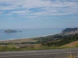 Waimarama from the hills above, with Bare Island to the left | |
 Waimarama | |
| Coordinates: 39°48′57″S 176°59′20″E / 39.8159°S 176.9889°E | |
| Country | New Zealand |
| Region | Hawke's Bay |
| Territorial authority | Hastings District |
Waimarama (Māori for 'moon over shining water') is a seaside village in Hastings District, Hawke's Bay, New Zealand.
Waimarama is a popular surf beach, known as a beach break on a sandy beach, with a rocky point. It offers both left and right handers and conditions are often suitable for surfers of all levels. The beach has strong rip currents, and is patrolled by surf lifeguards at weekends from November to March.[1]
Motu-o-Kura or Bare Island is located just off the coast and is a popular spot for fishing and diving.[2]
The beach town attracts people from across the region, with a restaurant, bar and shop. It also has about 240 permanent residents, with many former holiday baches becoming homes.
On 28 April 2011, heavy rain hit the village, causing floods and mudslides.[3]