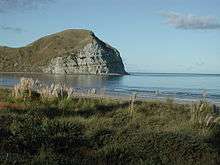
Mahia Peninsula

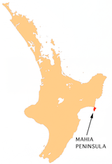
Mahia Peninsula (Maori: "Te Māhia"),[1] is located on the east coast of New Zealand's North Island, in the Hawke's Bay region, between the cities of Napier and Gisborne.
Geography
The peninsula is 21.7 kilometres (13.5 mi) long and 11.3 km (7 mi) wide. Its highest point is Rahuimokairoa (397 m (1,302 ft)) above sea level. The peninsula was once an island, but now a tombolo joins it to the North Island.[2]
History
The peninsula is the tribal area of the Maori iwi Ngāti Rongomaiwahine.[3] The word māhia means "indistinct sound" or "scrofulous swelling".[4] The name "Te Māhia" comes from "Te Māhia-mai-tawhiti" (the sound heard from a distance).
Portland Island ('Waikawa') is a small island off the southern tip of Mahia Peninsula with an unmanned lighthouse. It was named by Kahungunu when he visited there to look for fresh drinking water and only found salt water. Waikawa means "sour water".
Whales often strand on the shallow sand build up.
Shore whaling was briefly important on the Mahia Peninsula[5][6] and early whalers had a whaling station on the farm "Kini Kini", sheltered by "Long Point" on the west coast of the peninsula.
Culture
The area is a popular school holiday destination and contains a holiday park dating back to the 1960s. The remaining settlement consists mostly of holiday houses and baches. Sheep and cattle farms are still an important part for the local community, however the most important activity of the area is tourism. Mahia's population swells greatly during the warmer months and in particular during school holidays. Mahia is famous for its surf, scuba diving, hiking, and fishing.[7] Many tourists stay in Napier, Hastings or Wairoa and travel to Mahia Peninsula for the day. Morere Hot Springs is 15 minutes away, towards Gisborne.
In Maori legend, Whatonga who came to New Zealand in search of his grandfather Toi, settled at Mahia. The community these days is still generally a mix of Maori and European.
From 2007 to 2010 Mahia was famous for the presence of Moko the Dolphin.
Rocket range
The Rocket Lab company has set up their Launch Complex 1 close to Ahuriri Point at the southern tip of the peninsula to launch its Electron rocket. Test launches of the Electron started in 2017. During regular operations, it will be used as a commercial launcher of small satellites in the range of 300-500 pounds, and miniature satellites called CubeSats.[8] New Zealand's first orbital space launch took place from Launch Complex 1 on 21 January 2018.
References
- ↑ Whaanga, Mere (10 Feb 2015). "Ngāti Rongomaiwahine - Māhia Peninsula". Te Ara – the Encyclopedia of New Zealand. Manatū Taonga Ministry for Culture and Heritage. Retrieved 8 February 2018.
- ↑ "Destination: Mahia Peninsula". The New Zealand Bay Fisher. Ink IQ. Retrieved 8 February 2018.
- ↑ "Story: Ngāti Rongomaiwahine".
- ↑ Williams, Herbert W. (1971). "Māhia". A Dictionary of the Maori Language (7th ed.). p. 163.
- ↑ "Shore-based whaling". Te Ara. Retrieved 22 May 2017.
- ↑ Shortt, Bill (7 February 2016). "Mahia takes the cake". The Gisborne Herald. Retrieved 8 February 2018.
- ↑ "Mahia Travel Guide". Jasons Travel Media.
- ↑ Rocket Lab Plans Electron Test Launches This Year. Jeff Foust, Space News. 19 April 2016.
External links
| Wikimedia Commons has media related to Mahia Peninsula. |
Coordinates: 39°09′S 177°54′E / 39.150°S 177.900°E