Lake Tūtira
| Lake Tūtira | |
|---|---|
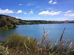 Lake Tutira in 2009 | |
| Location | Hawke's Bay, North Island |
| Coordinates | 39°13′19″S 176°53′35″E / 39.222°S 176.893°ECoordinates: 39°13′19″S 176°53′35″E / 39.222°S 176.893°E |
| Type | mesotrophic |
| Catchment area | 27 km2 (10 sq mi) |
| Basin countries | New Zealand |
| Surface area | 1.74 km2 (0.67 sq mi) |
| Average depth | 20.8 m (68 ft) |
| Max. depth | 42 m (138 ft) |
| Residence time | 2 years |
| Surface elevation | 150 m (490 ft) |
| Islands | 1 |
Lake Tūtira is a body of water in north-eastern Hawke's Bay in New Zealand. Much of the area was surveyed by Herbert Guthrie-Smith, who farmed 60,000 acres (240 km²) surrounding the lake. Guthrie-Smith, a naturalist, published the popular Tutira: the story of a New Zealand sheep station in 1921. Today, a camp is run at the site of his homestead.
A small settlement is also located near the lake, on State Highway 2 30 kilometres north of Whirinaki.
Sedimentary cores from the lake were used to demonstrate that the landslides mobilising sediments for transport into the lake occur in frequency and magnitude according to a power law.[1]
Trout fishing is permitted as a stream flows into its northern reaches. For centuries Maori seasonally lived by Lake Tūtira and you can see the remains of six pa sites. The Tutira Walkway, ascends to the Table Mountain trig station for stunning views over Hawke's Bay and takes about five hours to complete.
The lake suffers from periodic algal blooms.[2]
Geological history
The lake contains a high-resolution record of the sedimentation since its formation about 6,500 years ago.[3] It has a small catchment area, whose dominant erosion mechanism is landsliding; as a result of this, infrequent, large storms account for the bulk of the sedimentary depositional volume; Cyclone Bola is a particularly important recent example.[4][5]
References
- ↑ Gomez, B.; Page, M.; Bak, P.; Trustrum, N. (2002). "Self-organized criticality in layered, lacustrine sediments formed by landsliding". Geology. 30 (6): 519–522. doi:10.1130/0091-7613(2002)030#3C0519:SOCILL#3E2.0.CO;2 (inactive 2018-09-22).
- ↑ "High bacteria levels grow in Hawkes Bay lake". Hawke's Bay Today/The New Zealand Herald. 8 October 2012. Retrieved 14 February 2013.
- ↑ Eden, D.N.; Froggatt, P.C.; Trustrum, N.A.; Page, M.J. (1993). "A multiple-source Holocene tephra sequence from Lake Tutira, Hawke's Bay, New Zealand". New Zealand Journal of Geology and Geophysics. 36 (2): 233–242. doi:10.1080/00288306.1993.9514571.
- ↑ Page, M.J.; Trustrum, N.A.; Derose, R.C. (1994). "A high resolution record of storm-induced erosion from lake sediments, New Zealand". Geomorphology. 9 (3): 169. doi:10.1007/BF00677993.
- ↑ Page, M.; Trustrum, N; Dymond, J (1994). "Sediment budget to assess the geomorphic effect of a cyclonic storm, New Zealand". Geomorphology. 9 (3): 169. doi:10.1016/0169-555X(94)90061-2.
External links
| Wikimedia Commons has media related to Lake Tutira. |