Tangipahoa Parish, Louisiana
| Tangipahoa Parish, Louisiana | |
|---|---|
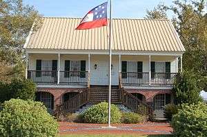 Museum at Camp Moore. | |
 Location in the U.S. state of Louisiana | |
 Louisiana's location in the U.S. | |
| Founded | 6 March, 1869 |
| Named for | Acolapissa word meaning ear of corn or those who gather corn |
| Seat | Amite City |
| Largest city | Hammond |
| Area | |
| • Total | 823 sq mi (2,132 km2) |
| • Land | 791 sq mi (2,049 km2) |
| • Water | 32 sq mi (83 km2), 3.9% |
| Population (est.) | |
| • (2017) | 132,497[1] |
| • Density | 167/sq mi (64/km2) |
| Congressional districts | 1st, 5th |
| Time zone | Central: UTC−6/−5 |
| Website |
www |

Tangipahoa Parish ( /ˌtændʒɪpəˈhoʊə/; French: Paroisse de Tangipahoa) is a parish located in the southeast of the U.S. state of Louisiana. As of the 2010 census, the population was 121,097.[2] The parish seat is Amite City,[3] while the largest city is Hammond. Southeastern Louisiana University is located in Hammond. Lake Pontchartrain borders the southeast side of the parish.
The name Tangipahoa comes from an Acolapissa word meaning "ear of corn" or "those who gather corn." The parish was organized in 1869 during Reconstruction.[4]
Tangipahoa Parish comprises the Hammond, LA Metropolitan Statistical Area, which is also included in the New Orleans-Metairie-Hammond, LA-MS Combined Statistical Area. It is one of what are called the Florida Parishes, at one time part of West Florida.
History
Tangipahoa Parish was organized in 1869, during Reconstruction, when it was put together from territory taken from Livingston Parish, St. Helena Parish, St. Tammany Parish, and Washington Parish. It was named after the Tangipahoa River and the historic Tangipahoa Native American people of this area. Tangipahoa is the youngest parish in the Florida Parishes region of southern Louisiana.
Parts of this area had already been developed for sugar cane plantations when the parish was organized, but yeomen farmers occupied areas in the piney woods and resisted planters' dominance. African Americans comprised about one-quarter of the population overall in the Florida Parishes before the war.[5]
The region developed rapidly during and after Reconstruction. There were conflicts in Tangipahoa Parish among interests related to construction of railroads, exploitation of timber, yeoman farmers in the piney woods keeping truck farms, and the beginning of manufacturing. Sugar cane depended on the labor of large gangs of enslaved African Americans before the Civil War. After the war and emancipation, some freedmen stayed to work on the plantations as laborers. Others moved to New Orleans and other cities, seeking different work. This area had rapid development and a high rate of immigrants and migrants from other areas of the country. The eastern Florida Parishes had the most mob violence and highest rate of lynchings in southern Louisiana.[5]
Especially after Reconstruction, whites worked to control the freedmen and establish dominance. Piney woods whites resisted the planters' efforts to restore their power, but imposed their own brutal violence on freedmen. Tangipahoa Parish was made more volatile by a "pronounced in-migration" of northerners (from the Midwest) and Sicilian immigrants, coupled with "industrial development along the Illinois Central Railroad, and crippling political factionalism." [5] With competition among ethnic groups for new jobs and power, these elements contributed to the high rate of lynchings and white mob violence; piney woods whites and migrants operated outside the legal system.
During the period of 1877-1950; a total of 24 blacks were lynched by whites in the parish as a means of racial terrorism and intimidation. This was the sixth highest total of any parish in Louisiana[6] and the highest number of any parish in southern Louisiana.[5] Twenty-two of these murders took place from 1879-1919, a time of heightened violence in the state. Unlike some other parishes, Tangipahoa did not have a high rate of legal executions of blacks; the whites operated outside the justice system altogether.[5] Among those lynched and hanged by a mob was Emma Hooper, a black woman who had shot and wounded a constable.[7]
In 1898 the Louisiana state legislature disenfranchised blacks by raising barriers to voter registration, excluding them from politics for decades, until after passage of federal civil rights legislation. In the first half of the 20th century, many African Americans left Tangipahoa Parish to escape the violence and oppression of Jim Crow, moving to industrial cities in the Great Migration. During World War II, they moved to the West Coast, where the buildup of the defense industry opened up new jobs. In the 21st century, they constitute a minority in the parish.
Timber, agriculture and industry are still important to the parish. It suffered flooding in 1932 and in the early 1980s. In 2016, Tangipahoa was one of many parishes declared a Federal disaster area due to historic flooding from rainfall and storms in both March and August.
Geography
According to the U.S. Census Bureau, the parish has a total area of 823 square miles (2,130 km2), of which 791 square miles (2,050 km2) is land and 32 square miles (83 km2) (3.9%) is water.[8] Lake Pontchartrain lies on the southeast side of the parish.
Most of the parish south of Ponchatoula consists of Holocene coastal swamp and marsh—gray-to-black clays of high organic content and thick peat beds underlying freshwater marsh and swamp.[9]
Adjacent counties and parishes
- Amite County, Mississippi (northwest)
- Pike County, Mississippi (northeast)
- St. Tammany Parish (east)
- Washington Parish (east)
- St. John the Baptist Parish (south)
- Livingston Parish (west)
- St. Helena Parish (west)
Transportation
Railroads
Amtrak's daily City of New Orleans long-distance train stops in Hammond, both northbound (to Chicago) and southbound. It serves about 15,000 riders a year, and Hammond-Chicago is the ninth-busiest city pair on the route.[10]
The historic main line of the Illinois Central that carries freight through the parish is now part of CN. It continues to be busy.
Highways


Demographics
| Historical population | |||
|---|---|---|---|
| Census | Pop. | %± | |
| 1870 | 7,928 | — | |
| 1880 | 9,638 | 21.6% | |
| 1890 | 12,655 | 31.3% | |
| 1900 | 17,625 | 39.3% | |
| 1910 | 29,160 | 65.4% | |
| 1920 | 31,440 | 7.8% | |
| 1930 | 46,227 | 47.0% | |
| 1940 | 45,519 | −1.5% | |
| 1950 | 53,218 | 16.9% | |
| 1960 | 59,434 | 11.7% | |
| 1970 | 65,875 | 10.8% | |
| 1980 | 80,698 | 22.5% | |
| 1990 | 85,709 | 6.2% | |
| 2000 | 100,588 | 17.4% | |
| 2010 | 121,097 | 20.4% | |
| Est. 2017 | 132,497 | [11] | 9.4% |
| U.S. Decennial Census[12] 1790-1960[13] 1900-1990[14] 1990-2000[15] 2010-2013[2] | |||
As of the census[16] of 2000, there were 100,588 people, 36,558 households, and 25,773 families residing in the parish. The population density was 127 people per square mile (49/km²). There were 40,794 housing units at an average density of 52 per square mile (20/km²). The racial makeup of the parish was 69.76% White, 28.35% Black or African American, 0.39% Asian, 0.24% Native American, 0.01% Pacific Islander, 0.46% from other races, and 0.78% from two or more races. 1.53% of the population were Hispanic or Latino of any race.
There were 36,558 households out of which 35.30% had children under the age of 18 living with them, 49.90% were married couples living together, 16.20% had a female householder with no husband present, and 29.50% were non-families. 24.00% of all households were made up of individuals and 8.40% had someone living alone who was 65 years of age or older. The average household size was 2.66 and the average family size was 3.19.
In the parish the population was spread out with 27.70% under the age of 18, 12.70% from 18 to 24, 27.70% from 25 to 44, 21.20% from 45 to 64, and 10.60% who were 65 years of age or older. The median age was 32 years. For every 100 females there were 93.00 males. For every 100 females age 18 and over, there were 88.60 males.
The median income for a household in the parish was $29,412, and the median income for a family was $36,731. Males had a median income of $31,576 versus $20,066 for females. The per capita income for the parish was $14,461. About 18.00% of families and 22.70% of the population were below the poverty line, including 28.60% of those under age 18 and 20.10% of those age 65 or over.
Government and politics

The parish is part of Louisiana's 1st congressional district. Since the late 20th century the conservative, white-majority voters have left the Democratic Party and shifted to the Republican Party. African Americans have supported the Democratic Party and its candidates.
The parish government is governed by the Louisiana State Constitution and the Tangipahoa Parish Home Rule Charter. The Parish Government of Tangipahoa is headed by a parish president and a parish council (president-council government). The council is the legislative body of the parish, with authority under Louisiana State Constitution, the Parish Home Rule Charter, and laws passed by the Louisiana State Legislature. The Parish Sheriff is the chief law enforcement officer; other elected officers include the coroner, assessor, and clerk of court.
Keith Bardwell, justice of the peace for the parish's 8th ward (Robert, Louisiana), attracted attention in October 2009 for refusing to officiate the wedding of an interracial couple. Bardwell, a justice of the peace for 34 years, had concluded that "most black society does not readily accept offspring of such relationships, and neither does white society". He said he does not perform weddings for interracial marriages because "I don't want to put children in a situation they didn't bring on themselves."[17] Bardwell said he had refused to perform the weddings of four couples during the 2½-year period before the news of his actions was publicized, resigned effective November 3, 2009.[18] Governor Bobby Jindal said that the resignation was "long overdue."[18]
Parish officers
- Parish President – Charles Robert "Robby" Miller, Jr. (R), since 2016
- Sheriff – Daniel H. Edwards (D), since 2004
- Clerk of Court – Gary Stanga (D), since 2017
- Coroner – Dr. Rick Foster (D), since 2000
- Assessor – Joaquin "Junior" Matheu (D), since 2005
Parish Council
Tangipahoa Parish is governed by an elected ten-member Council, each representing a geographic district and roughly equal populations. As of October 2016 its chairman was Bobby Cortez. Kristen Pecararo is the clerk of the council.[19]
District 1 – Trent Forrest (D) from Kentwood
District 2 – James Bailey (R) from Husser
District 3 – Louis Nick Joseph (D) from Independence
District 4 – Carlo S. Bruno (Other) from Independence
District 5 – H. G. "Buddy" Ridgel (D)[20] from Hammond
District 6 – Emile "Joey" Mayeaux (R) from Hammond
District 7 – Lionell Wells (D) from Hammond
District 8 – David Vial (R) from Hammond
District 9 – Harry Lavine (R) from Ponchatoula
District 10 – Bobby Cortez (R) from Hammond
President of Tangipahoa Parish
In 1986 the former governing body of Tangipahoa Parish, the Tangipahoa Police Jury, and the voters of the Parish approved a "home rule charter" style of government. The charter provided for the election of a parish president, essentially a parish-wide mayor. Democrat Gordon A. Burgess was elected to an initial one-year term and re-elected the following year for a four-year term. Burgess was repeatedly re-elected as parish president until he retired in 2015.
In 2016, Republican businessman Robert "Robby" Miller succeeded Burgess. In April 2016, the Parish hired its first chief administrative officer, Shelby "Joe" Thomas, Jr. to handle operating functions.[21]
| President | Terms of Office | Party |
|---|---|---|
| Gordon Burgess | October 27, 1986 – January 11, 2016 | Democratic |
| Robby Miller | January 11, 2016 – incumbent | Republican |
| Year | Republican | Democratic | Third parties |
|---|---|---|---|
| 2016 | 64.8% 33,959 | 32.2% 16,878 | 3.0% 1,579 |
| 2012 | 63.1% 31,590 | 35.4% 17,722 | 1.6% 787 |
| 2008 | 64.7% 31,434 | 33.8% 16,438 | 1.5% 730 |
| 2004 | 62.1% 26,181 | 36.4% 15,345 | 1.5% 609 |
| 2000 | 55.0% 20,421 | 42.6% 15,843 | 2.4% 891 |
| 1996 | 41.3% 15,517 | 49.5% 18,617 | 9.2% 3,457 |
| 1992 | 41.3% 14,128 | 44.4% 15,194 | 14.4% 4,923 |
| 1988 | 54.3% 16,669 | 44.1% 13,527 | 1.6% 492 |
| 1984 | 60.1% 19,580 | 39.3% 12,799 | 0.6% 200 |
| 1980 | 48.5% 15,187 | 48.7% 15,272 | 2.8% 883 |
| 1976 | 38.0% 9,242 | 59.4% 14,432 | 2.6% 637 |
| 1972 | 62.9% 11,607 | 28.3% 5,227 | 8.8% 1,623 |
| 1968 | 13.9% 2,907 | 23.8% 4,983 | 62.4% 13,088 |
| 1964 | 57.8% 9,732 | 42.2% 7,109 | |
| 1960 | 22.9% 3,285 | 46.3% 6,648 | 30.8% 4,418 |
| 1956 | 51.8% 5,788 | 43.2% 4,831 | 5.1% 566 |
| 1952 | 46.9% 5,166 | 53.1% 5,850 | |
| 1948 | 17.4% 1,287 | 29.5% 2,184 | 53.1% 3,937 |
| 1944 | 26.2% 1,572 | 73.8% 4,419 | |
| 1940 | 17.9% 1,284 | 82.1% 5,900 | 0.0% 3 |
| 1936 | 22.9% 1,374 | 77.1% 4,624 | 0.0% 2 |
| 1932 | 9.4% 455 | 90.6% 4,404 | 0.1% 3 |
| 1928 | 33.3% 1,415 | 66.7% 2,834 | |
| 1924 | 22.8% 479 | 77.2% 1,626 | |
| 1920 | 22.7% 440 | 77.3% 1,501 | |
| 1916 | 10.6% 159 | 88.6% 1,326 | 0.8% 12 |
| 1912 | 3.0% 40 | 80.0% 1,061 | 17.0% 225 |
Education
The parish is served by the Tangipahoa Parish School System.[23] Southeastern Louisiana University is located in Hammond.
On seven occasions, the American Civil Liberties Union has sued the Tangipahoa Parish School Board, along with other defendants, for having allegedly sponsored and promoted religion in teacher-led school activities.[24]
School Board
The elected school board governs and oversees the Tangipahoa Parish School System (TPSS). The board appoints the superintendent of schools, who leads the TPSS and oversees is functioning. The current superintendent is Mark Kolwe. The president of the board is Andy Anderson.
Mark Kolwe, superintendent
Walter Daniels (D)
Gail Pittman-McDaniel (R)
Andy Anderson (R)
Therese Domiano (O)
Brett Duncan (R)
Mike Whitlow (R)
Betty Robinson (D)
Sandra Bailey-Simmons (R)
Rose Dominguez (R)
The Board has a long history of racial discrimination in the hiring of teachers. In 1975, it was ordered to ensure one-third of the teaching staff were Black. Both the Board and the Court ignored the mandate for more than thirty years. During the period from 1998 to 2008, the Board hired fewer Black teachers than any other school system in the state. In 2010, a second ruling strengthened the first.[25]
National Guard
The parish is home to the 204th Theater Airfield Operations Group and the Forward Support Company of the 205th Engineer Battalion. This 205th Engineer Battalion is a component of the 225th Engineer Brigade of the Louisiana National Guard. These units reside within the city of Hammond. A detachment of the 1021st Engineer Company (Vertical) resides in Independence, Louisiana. The 236th Combat Communications Squadron of the Louisiana Air National Guard also resides at the Hammond Airport.
Communities
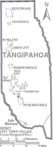
Cities
Towns
- Amite City (parish seat)
- Independence
- Kentwood
- Roseland
Villages
Census-designated place
Other unincorporated places
Notable people
- Chris Broadwater, current District 86 state representative, resides in Hammond
- Nick Bruno, president of University of Louisiana at Monroe
- Hodding Carter, 20th-century journalist
- William Hodding Carter, I, politician; father of Hodding Carter
- John L. Crain, president of Southeastern Louisiana University
- John Desmond, architect
- John Bel Edwards, current Governor of Louisiana; former Minority Leader of Louisiana House of Representatives; former District 72 state representative, resides in Amite
- Lucy Fleming, singer
- C. B. Forgotston, political activist
- Barbara Forrest, critic of intelligent design
- Robert L. Frye, educator
- Tim Gautreaux, writer
- Dennis Paul Hebert, state representative for Tangipahoa Parish, 1972-1996[26]
- Bolivar E. Kemp, U.S. representative, 1925–1933
- Bolivar Edwards Kemp, Jr., Louisiana Attorney General, 1948–1952
- Wade Miley, professional baseball pitcher
- James H. Morrison, represented Louisiana's 6th congressional district from 1943 to 1967
- Kim Mulkey, college basketball player, United States Olympic Team, Baylor head women's basketball coach
- Rufus Porter, professional football player
- Henry "Tank" Powell, state representative from 1996 to 2008
- Steve Pugh, state representative since 2008
- Billy Reid, fashion designer
- Beth Rickey, political activist who opposed David Duke and taught for a time at Southeastern Louisiana University[27]
- Weldon Russell, former state representative from Tangipahoa and St. Helena parishes
- Britney Spears, singer
- Jackie Smith, former professional football player, St. Louis Cardinals and Dallas Cowboys, NFL Hall of Famer
- Irma Thomas, Grammy-winning singer
- Harry D. Wilson, Louisiana state representative and state agriculture commissioner; pushed for the establishment of the town of Independence in 1912
- Justin Wilson, chef and humorist
- Robert Alford, professional football player, Atlanta Falcons
- Harlan Miller, professional football player, Arizona Cardinals
- Kevin Hughes, professional football player, St. Louis Rams and Carolina Panthers
- Donald Dykes, former professional football player, New York Jets and San Diego Chargers
- Earl Wilson, former major league baseball player for Boston Red Sox, Detroit Tigers and San Diego Padres
- LaBrandon Toefield, former professional football player, Jacksonville Jaguars and Carolina Panthers
See also
References
- ↑ https://www.census.gov/quickfacts/fact/table/tangipahoaparishlouisiana/PST045217
- 1 2 "State & County QuickFacts". United States Census Bureau. Retrieved August 18, 2013.
- ↑ "Find a County". National Association of Counties. Retrieved 2011-06-07.
- ↑ "Tangipahoa Parish". Center for Cultural and Eco-Tourism. Retrieved September 5, 2014.
- 1 2 3 4 5 Michael James Pfeifer, Rough Justice: Lynching and American Society, 1874-1947, University of Illinois Press, 2004, pp. 83-84
- ↑ Lynching in America, Third Edition: Supplement by County, p. 6, Equal Justice Initiative, Mobile, AL, 2017
- ↑ Pfeifer (2004), Rough Justice, p. 198, Footnote #104
- ↑ "2010 Census Gazetteer Files". United States Census Bureau. August 22, 2012. Archived from the original on September 28, 2013. Retrieved September 2, 2014.
- ↑ McCulloh, R. P.; P. V. Heinrich; J. Snead (2003). "Ponchatoula 30 x 60 Minute Geologic Quadrangle" (PDF). Louisiana Geological Survey. Baton Rouge, Louisiana: Louisiana State University. Archived from the original (PDF) on 2010-06-28. Retrieved 2009-10-17.
- ↑ "Amtrak Fact Sheet" (PDF). National Association of Railroad Passengers. 2015. Retrieved 2018-03-08.
- ↑ "Population and Housing Unit Estimates". Retrieved June 9, 2017.
- ↑ "U.S. Decennial Census". United States Census Bureau. Retrieved September 2, 2014.
- ↑ "Historical Census Browser". University of Virginia Library. Retrieved September 2, 2014.
- ↑ "Population of Counties by Decennial Census: 1900 to 1990". United States Census Bureau. Retrieved September 2, 2014.
- ↑ "Census 2000 PHC-T-4. Ranking Tables for Counties: 1990 and 2000" (PDF). United States Census Bureau. Retrieved September 2, 2014.
- ↑ "American FactFinder". United States Census Bureau. Retrieved 2008-01-31.
- ↑ "JP refuses to marry couple". Daily Star (Hammond). October 15, 2009. Archived from the original on January 25, 2013. Retrieved 2009-10-17.
Bardwell said he came to the conclusion that most black society does not readily accept offspring of such relationships, and neither does white society.... "I don't do interracial marriages because I don't want to put children in a situation they didn't bring on themselves," Bardwell said. "In my heart, I feel the children will later suffer."
- 1 2 "US judge in mixed-race row quits". BBC News. 4 November 2009. Retrieved 2009-11-04.
- ↑ Council page on Parish website, accessed 19 Oct 2016.
- ↑ Tangipahoa Parish elected officials on the Louisiana Secretary of State's website, retrieved 19 Oct 2016.
- ↑ "Thomas named Tangipahoa Parish Government's first CAO". ActionNews17. Retrieved 2018-03-08.
- ↑ Leip, David. "Dave Leip's Atlas of U.S. Presidential Elections". uselectionatlas.org. Retrieved 2018-03-08.
- ↑ Official website of the Tangipahoa Parish School System
- ↑ Mitchell, David. "School board sued over prayer", Baton Rouge Morning Advocate, Capital City Press, p. B01.
- ↑ Anderson, Melinda (23 January 2018). "A Root Cause of the Teacher-Diversity Problem". The Atlantic. Retrieved 21 August 2018.
- ↑ "Dennis P. Hebert". The Baton Rouge Advocate. Retrieved September 13, 2015.
- ↑ Patricia Sullivan, "Beth Rickey dies with an immune disorder and Crohn's disease," Washington Post, September 16, 2009
External links
- Tangipahoa Parish official website
- Tangipahoa Parish history, on the Convention and Visitors Bureau website
- "Explore the History and Culture of Southeastern Louisiana". Discover Our Shared Heritage Travel Itinerary. National Park Service.
Places adjacent to Tangipahoa Parish, Louisiana | |
|---|---|
Municipalities and communities of Tangipahoa Parish, Louisiana, United States | ||
|---|---|---|
| Cities | | |
| Towns | ||
| Villages | ||
| CDP | ||
| Other Unincorporated communities | ||