Ponchatoula, Louisiana
| Ponchatoula, Louisiana | |
|---|---|
| City | |
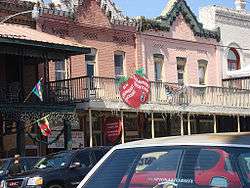 Ponchatoula during the 2007 Strawberry Festival | |
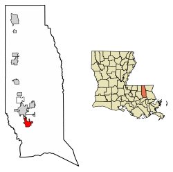 Location of Ponchatoula in Tangipahoa Parish, Louisiana. | |
.svg.png) Location of Louisiana in the United States | |
| Coordinates: 30°26′21″N 90°26′33″W / 30.43917°N 90.44250°WCoordinates: 30°26′21″N 90°26′33″W / 30.43917°N 90.44250°W | |
| State | Louisiana |
| Parish | Tangipahoa |
| Area[1] | |
| • Total | 4.58 sq mi (11.87 km2) |
| • Land | 4.57 sq mi (11.84 km2) |
| • Water | 0.01 sq mi (0.03 km2) |
| Elevation | 26 ft (8 m) |
| Population (2010) | |
| • Total | 6,559 |
| • Estimate (2016)[2] | 7,209 |
| • Density | 1,577.46/sq mi (609.04/km2) |
| Time zone | UTC−6 (CST) |
| • Summer (DST) | UTC−5 (CDT) |
| ZIP code | 70454 |
| Area code(s) | 985 |
| FIPS code | 22-61615 |
| Website | City of Ponchatoula, Louisiana |
Ponchatoula is a small city in Tangipahoa Parish, Louisiana, United States. The population was 6,559 at the 2010 census.
History
Ponchatoula was originally established as a mining camp in 1820, incorporating as a town on February 12, 1861. William Akers was the first mayor and is credited with founding the town, establishing it on land he purchased from the Federal government in 1832.[3]
At the turn of the 20th century the local area changed its chief industry from lumber to commercial farming. The main produce was the strawberry. The families who were major farmers during this era, which lasted about eighty years, have their last names engraved on a large plaque in front of city hall. The Strawberry Festival's roots go back to when farmers joined to sell the spring harvest of strawberries. Today it is the second largest event in the state, after Mardi Gras.
During the 1980s the local economy changed to tourism, when farming no longer earned enough to sustain the town. The mayor at the time devised a plan to open antique shops where former businesses had been located. There are still about six of these shops in operation. This gave the town a second nickname, "America's Antique City."
Ponchatoula is a name signifying "falling hair" or "hanging hair" or "flowing hair" from the Choctaw Pashi "hair" and itula or itola "to fall" or "to hang" or "flowing." It was the Indians' way of expressing the beauty of the location, with much Spanish moss hanging from the trees. "Ponche" is an Indian word meaning location, object, or person.[4] The name is eponymous with the Ponchatoula Creek, which flows from points north of the city into the Natalbany River southwest of town.
Civil War
Ponchatoula was pillaged in 1863 by the Union Army during the American Civil War. After a light skirmish, Confederate troops withdrew, and the 6th Michigan Volunteer Infantry Regiment occupied the town. Historian John D. Winters describes the fate of Ponchatoula:
"Women and children scampered about, begging for protection. There was no Confederate force to be found, and suddenly all discipline crumbled. The men went wild, and they were joined in the orgy of pillage by their corpulent commander Colonel [Thomas S.] Clark. First the depot was sacked, and the men grabbed up bundles and boxes they found stored within. The next targets were the two small stores in the village. The doors were battered in, and the blue-coated soldiers rushed in. The liquor supply was quickly confiscated. The post office was ...
"Colonel Clark was disappointed to find no cotton in Ponchatoula, but he consoled himself by gathering all of the mules and wagons in the vicinity, loading them with valuable turpentine and resin and with the plunder of the village, and sending them ... to be loaded aboard waiting schooners. The citizens of the town who remained behind were administered the Federal oath of allegiance and promised protection by the officers."[5]
Geography
Ponchatoula is located at 30°26′21″N 90°26′33″W / 30.43917°N 90.44250°W (30.439162, -90.442507)[6] and has an elevation of 26 feet (7.9 m).[7] According to the United States Census Bureau, the city has a total area of 4.2 square miles (11 km2), all land.
Ponchatoula is located along Interstate 55 and Louisiana Highway 22, equidistant from New Orleans and Baton Rouge. In the early 1900s, Ponchatoula was one of only two ways to reach New Orleans by land, thus earning the moniker "Gateway to New Orleans."
Demographics
| Historical population | |||
|---|---|---|---|
| Census | Pop. | %± | |
| 1870 | 320 | — | |
| 1880 | 293 | −8.4% | |
| 1890 | 459 | 56.7% | |
| 1900 | 711 | 54.9% | |
| 1910 | 1,055 | 48.4% | |
| 1920 | 955 | −9.5% | |
| 1930 | 2,898 | 203.5% | |
| 1940 | 4,001 | 38.1% | |
| 1950 | 4,090 | 2.2% | |
| 1960 | 4,727 | 15.6% | |
| 1970 | 4,545 | −3.9% | |
| 1980 | 5,469 | 20.3% | |
| 1990 | 5,425 | −0.8% | |
| 2000 | 5,180 | −4.5% | |
| 2010 | 6,559 | 26.6% | |
| Est. 2016 | 7,209 | [2] | 9.9% |
| U.S. Decennial Census[8] | |||
As of the 2000 census,[9] there were 5,180 people, 1,984 households, and 1,372 families residing in the city. The population density was 1,226.7 people per square mile (473.9/km²). There were 2,175 housing units at an average density of 515.1 per square mile (199.0/km²). The racial makeup of the city was 62.20% White, 36.83% African American, 0.19% Native American, 0.12% Asian, 0.15% from other races, and 0.50% from two or more races. Hispanic or Latino of any race were 0.85% of the population.
There were 1,984 households out of which 34.9% had children under the age of 18 living with them, 41.2% were married couples living together, 23.1% had a female householder with no husband present, and 30.8% were non-families. 27.1% of all households were made up of individuals and 11.5% had someone living alone who was 65 years of age or older. The average household size was 2.60 and the average family size was 3.16.
In the city, the population was spread out with 29.8% under the age of 18, 9.9% from 18 to 24, 26.9% from 25 to 44, 21.0% from 45 to 64, and 12.4% who were 65 years of age or older. The median age was 33 years. For every 100 females, there were 85.9 males. For every 100 females age 18 and over, there were 79.1 males.
The median income for a household in the city was $22,244, and the median income for a family was $29,583. Males had a median income of $30,285 versus $18,952 for females. The per capita income for the city was $12,157. About 27.9% of families and 31.7% of the population were below the poverty line, including 46.9% of those under age 18 and 15.1% of those age 65 or over.
Education
Tangipahoa Parish School System operates public schools:
- Ponchatoula High School (near Ponchatoula)
- Ponchatoula Junior High School
- Martha Vineyard Elementary School (near Ponchatoula)
- D. C. Reeves Elementary School
- Perrin Early Learning Center
Visitor attractions
Ponchatoula hosts Louisiana's Strawberry Festival each April and an Oktoberfest each autumn.
The town is noted for its many antique shops along Pine Street (LA 22), open year-round. Ponchatoula is small, but it has a number of attractions including a sign on the outskirts of town with how many miles it lies from South Dakota's Wall Drug store.
The old train depot has been converted into the Country Market, a series of booths for local craftsmen and artisans. Next door is the Art Station, a train car which has been turned into an art gallery for local painters. In the same block lives Ole Hardhide, an alligator. .
Across Highway 22 from Hardhide is the Collinswood School Museum, a former one-room schoolhouse which exhibits local artifacts and quilts. Between the school museum and the tracks stands the Strawberry Train, which is a steam engine and single passenger car roped off in such a way that children can safely climb into the engine and the car.
The Chamber of Commerce office is located on Highway 22 at the railroad tracks and has information about these and other sights in Ponchatoula and the surrounding area.
Notable people
- Irwin Davis, football player, coach, and administrator
- Dennis Paul Hebert, Sr., state representative for Tangipahoa Parish, 1972-1996
- Michael I. Jordan, researcher in Machine Learning and Artificial Intelligence
- Trevante Rhodes, actor, sprinter
- Bernie Smith, baseball player
- Irma Thomas, singer
- Earl Wilson, baseball player
See also
References
- ↑ "2016 U.S. Gazetteer Files". United States Census Bureau. Retrieved Jul 12, 2017.
- 1 2 "Population and Housing Unit Estimates". Retrieved June 9, 2017.
- ↑ Lindsay, C. H.; Dufreche, Julian. "The History of Ponchatoula". Retrieved 2015-01-04.
- ↑ Ponchatoula City website.
- ↑ John D. Winters, The Civil War in Louisiana, Baton Rouge: Louisiana State University Press, 1963, ISBN 0-8071-0834-0, p. 219
- ↑ "US Gazetteer files: 2010, 2000, and 1990". United States Census Bureau. 2011-02-12. Retrieved 2011-04-23.
- ↑ "US Board on Geographic Names". United States Geological Survey. 2007-10-25. Retrieved 2008-01-31.
- ↑ "Census of Population and Housing". Census.gov. Retrieved June 4, 2015.
- ↑ "American FactFinder". United States Census Bureau. Retrieved 2008-01-31.
External links
- City of Ponchatoula - Official Website of the City of Ponchatoula, LA
- The Ponchatoula Times
- Ponchatoula Chamber of Commerce
- Ponchatoula Strawberry Festival
- MyHammond–MyPonchatoula directory
Municipalities and communities of Tangipahoa Parish, Louisiana, United States | ||
|---|---|---|
| Cities |  | |
| Towns | ||
| Villages | ||
| CDP | ||
| Other Unincorporated communities | ||