St. Martin Parish, Louisiana
| Saint Martin Parish, Louisiana | |
|---|---|
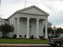 St. Martin Parish Courthouse, St. Martinville | |
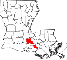 Location in the U.S. state of Louisiana | |
 Louisiana's location in the U.S. | |
| Founded | 1811 |
| Named for | St. Martin |
| Seat | St. Martinville |
| Largest city | Breaux Bridge |
| Area | |
| • Total | 816 sq mi (2,113 km2) |
| • Land | 738 sq mi (1,911 km2) |
| • Water | 79 sq mi (205 km2), 9.7% |
| Population (est.) | |
| • (2015) | 53,835 |
| • Density | 71/sq mi (27/km2) |
| Congressional district | 3rd |
| Time zone | Central: UTC−6/−5 |
| Website |
www |
St. Martin Parish (French: Paroisse de Saint-Martin) is a parish located in the U.S. state of Louisiana. As of the 2010 census, the population was 52,160.[1] The parish seat is St. Martinville.[2] The parish was founded in 1811.
St. Martin Parish is part of the Lafayette, Louisiana Metropolitan Statistical Area. 27% of the population of St. Martin Parish have French fluency, rated as one of the highest concentrations of French speakers in the nation.
History
In 1811, the division of Attakapas Parish created St. Martin Parish and St. Mary Parish. In 1824, St. Martin Parish was divided, resulting in the creation of Lafayette Parish. In 1844, St. Martin Parish was again divided, creating Vermilion Parish. In 1868, Iberia Parish was formed from parts of St. Martin Parish and St. Mary Parish, literally dividing St. Martin Parish in two, as part of Iberia Parish runs between the two non-contiguous parts of St. Martin Parish.
St. Martin Parish was largely colonized by people from France and Acadia in the 1700s, accounting for the large concentration of French-speaking population today. The Acadians brought with them the tale of Evangeline, a young woman who was separated from her supposedly-mortally-wounded betrothed during the Expulsion of the Acadians. According to the tale, Evangeline later met her betrothed in St. Martin Parish, but he had moved on to a new love and she never recovered from the shock of both finding him and losing him again. Henry Wadsworth Longfellow's most famous work, Evangeline, A Tale of Acadie, was based on this story. Evangeline was and remains an icon of Acadian and American culture. The historical Evangeline, who is believed by some to have been an orphan girl named Emmeline Labiche, is supposed to have been buried on the grounds of the St. Martin de Tours Catholic Church in St. Martinville.[3]
St. Martin was a very prosperous parish, growing rapidly in the early 1800s. Most of the money at that time was being made by raising cattle. Other profitable crops were cotton, sugar, corn, rice and tobacco. These were sold to the New Orleans market. Wealthy planters utilized slave labor on their plantations, and by 1860, there were over 7,000 slaves in the parish.
A yellow fever epidemic in 1855, followed by a deadly fire and a destructive hurricane, ended an era of unbridled prosperity. These events, combined with the effects of the Civil War and Reconstruction took a heavy toll on the parish. However, the people proved resilient, and in short order became prosperous again. Corn, cotton, and sugar cane ruled once more, and trees from the swamps were profitably sold.
Geography
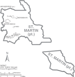
The parish is split into two non-contiguous parts because of a surveying error dating to 1868, when Iberia Parish was created by the Louisiana Legislature. According to the U.S. Census Bureau, the parish has a total area of 816 square miles (2,110 km2), of which 738 square miles (1,910 km2) is land and 79 square miles (200 km2) (9.7%) is water.[4] Iberia Parish divides St. Martin Parish into two separate areas, Upper and Lower St. Martin. St. Martin Parish is in the Atchafalaya Basin, with Bayou Teche running through it. The Bayou was used to ship products to New Orleans.
St. Martin Parish has a wealth of oak and magnolia trees.
Major highways
Adjacent parishes
- St. Landry Parish (north)
- Pointe Coupee Parish (northeast)
- Iberville Parish (east)
- Assumption Parish (southeast)
- St. Mary Parish (southwest)
- Lafayette Parish (west)
- Iberia Parish (south of Upper St. Martin/north of Lower St. Martin)
Protected areas
The parish has both national and state protected areas within its borders.
National protected area
State protected areas
Part of the Attakapas Wildlife Management Area is located within St. Martin Parish as well as in St. Mary and Iberia Parishes.[5]
Demographics
| Historical population | |||
|---|---|---|---|
| Census | Pop. | %± | |
| 1830 | 7,205 | — | |
| 1840 | 8,674 | 20.4% | |
| 1850 | 11,761 | 35.6% | |
| 1860 | 12,674 | 7.8% | |
| 1870 | 9,370 | −26.1% | |
| 1880 | 12,663 | 35.1% | |
| 1890 | 14,884 | 17.5% | |
| 1900 | 18,940 | 27.3% | |
| 1910 | 23,070 | 21.8% | |
| 1920 | 21,990 | −4.7% | |
| 1930 | 21,767 | −1.0% | |
| 1940 | 26,394 | 21.3% | |
| 1950 | 26,353 | −0.2% | |
| 1960 | 29,063 | 10.3% | |
| 1970 | 32,453 | 11.7% | |
| 1980 | 40,214 | 23.9% | |
| 1990 | 43,978 | 9.4% | |
| 2000 | 48,583 | 10.5% | |
| 2010 | 52,160 | 7.4% | |
| Est. 2016 | 54,007 | [6] | 3.5% |
| U.S. Decennial Census[7] 1790-1960[8] 1900-1990[9] 1990-2000[10] 2010-2013[1] | |||
As of the census[11] of 2000, there were 48,583 people, 17,164 households, and 12,975 families residing in the parish. The population density was 66 people per square mile (25/km²). There were 20,245 housing units at an average density of 27 per square mile (11/km²). The racial makeup of the parish was 65.95% White, 31.98% Black or African American, 0.92% Asian, 0.29% Native American, 0.20% from other races, and 0.65% from two or more races. Hispanics or Latinos of any race made up 0.83% of the population. The 2000 census counted 44,915 people in the parish who are at least five years old of whom 31,229 (69.5%) speak only English at home, 27.44% reported speaking French (Colonial French also known as Plantation Society French ) or Cajun French at home, while 1.52% speak Louisiana Creole French.[12] St. Martin has the highest percentage of French-speaking residents of any county or parish in the United States.
There were 17,164 households out of which 39.70% had children under the age of 18 living with them, 54.60% were married couples living together, 15.90% had a female householder with no husband present, and 24.40% were non-families. 20.70% of all households were made up of individuals and 7.90% had someone living alone who was 65 years of age or older. The average household size was 2.78 and the average family size was 3.22.
In the parish the population was spread out with 29.50% under the age of 18, 9.60% from 18 to 24, 29.60% from 25 to 44, 21.20% from 45 to 64, and 10.10% who were 65 years of age or older. The median age was 33 years. For every 100 females, there were 96.30 males. For every 100 females age 18 and over, there were 93.00 males.
The median income for a household in the parish was $30,701, and the median income for a family was $36,316. Males had a median income of $30,701 versus $18,365 for females. The per capita income for the parish was $13,619. About 18.40% of families and 21.50% of the population were below the poverty line, including 27.70% of those under age 18 and 22.10% of those age 65 or over.
Education
Public schools in St. Martin Parish are operated by the St. Martin Parish School Board.
Politics
| Year | Republican | Democratic | Third parties |
|---|---|---|---|
| 2016 | 65.5% 16,873 | 32.1% 8,266 | 2.4% 611 |
| 2012 | 61.6% 15,653 | 37.1% 9,422 | 1.4% 358 |
| 2008 | 59.6% 14,443 | 38.8% 9,419 | 1.6% 390 |
| 2004 | 53.0% 12,095 | 45.2% 10,321 | 1.8% 408 |
| 2000 | 47.9% 9,961 | 47.4% 9,853 | 4.6% 964 |
| 1996 | 30.4% 6,296 | 60.2% 12,492 | 9.4% 1,948 |
| 1992 | 28.9% 5,909 | 55.1% 11,252 | 16.0% 3,265 |
| 1988 | 41.6% 7,541 | 56.0% 10,148 | 2.4% 440 |
| 1984 | 52.2% 9,698 | 46.2% 8,589 | 1.6% 304 |
| 1980 | 44.6% 6,701 | 51.6% 7,760 | 3.9% 579 |
| 1976 | 33.1% 4,112 | 64.3% 7,992 | 2.7% 329 |
| 1972 | 62.0% 6,337 | 31.3% 3,202 | 6.7% 682 |
| 1968 | 16.7% 1,625 | 34.2% 3,321 | 49.0% 4,759 |
| 1964 | 37.4% 2,793 | 62.6% 4,675 | |
| 1960 | 12.2% 858 | 78.0% 5,506 | 9.9% 699 |
| 1956 | 42.7% 1,615 | 54.7% 2,069 | 2.5% 96 |
| 1952 | 43.6% 1,554 | 56.4% 2,012 | |
| 1948 | 18.0% 688 | 8.0% 307 | 74.0% 2,829 |
| 1944 | 6.0% 153 | 94.0% 2,384 | |
| 1940 | 15.6% 602 | 84.4% 3,252 | |
| 1936 | 3.7% 100 | 96.4% 2,638 | |
| 1932 | 7.0% 107 | 93.0% 1,420 | |
| 1928 | 11.3% 242 | 88.7% 1,892 | |
| 1924 | 26.2% 172 | 70.3% 461 | 3.5% 23 |
| 1920 | 56.8% 419 | 43.2% 319 | |
| 1916 | 2.6% 36 | 69.4% 971 | 28.0% 392 |
| 1912 | 11.7% 68 | 64.4% 375 | 23.9% 139 |
Communities
Cities
Towns
Village
Census-designated places
Unincorporated communities
Notable people
- Ali Landry, Miss USA 1996 pageant winner (actually from Nina Station)
- Scott Angelle, director of the Bureau of Safety and Environmental Enforcement, former member of the Louisiana Public Service Commission, former lieutenant governor, unsuccessful candidate for governor in 2015
- Drauzin Angelle, chief deputy sheriff of St. Martin Parish from 1924 to 1958
- Lottie Beebe, superintendent of St. Martin Parish public schools; member of the Louisiana Board of Elementary and Secondary Education
- Calvin Borel, American Thoroughbred Jockey and 3-time Kentucky Derby winner
- Gerald Boudreaux, state senator for St. Martin Parish, effective January 2016
- Jake Delhomme, retired NFL quarterback
- Charles Fuselier, sheriff of St. Martin Parish from 1980 to 2003; "National Sheriff of the Year" in 1996
- Jesse J. Guidry, state representative, former director of the Louisiana Department of Wildlife and Fisheries
- Mike "Pete" Huval, state representative; former member of the St. Martin Parish Council
- Sam Irwin, author, Louisiana Crawfish: A Succulent History of the Cajun Crustacean; Press Secretary - Louisiana Department of Agriculture & Forestry (2008-2012).
- Jeff Landry, Attorney General of Louisiana; former U.S. representative
- Wade O. Martin, Jr., secretary of state
- Wade O. Martin, Sr., Louisiana public service commissioner.
- James D. Simon, state senator
- Pat Huval, first mayor of Henderson and founder of Pat's Waterfront Restaurant.
NRHP
There are several historically significant locations listed on the National Register of Historic Places that includes Acadian House (St. Martinville, Louisiana), St. Martin of Tours Catholic Church, and the D. W. Voorhies House.
See also
References
- 1 2 "State & County QuickFacts". United States Census Bureau. Retrieved August 18, 2013.
- ↑ "Find a County". National Association of Counties. Retrieved 2011-06-07.
- ↑ Perrin, William Henry (1891). Southwest Louisiana, biographical and historical. The Library of Congress. New Orleans : Gulf Publishing Co.
- ↑ "2010 Census Gazetteer Files". United States Census Bureau. August 22, 2012. Archived from the original on September 28, 2013. Retrieved September 1, 2014.
- ↑ Attakapas WMA- Retrieved 2017-02-19
- ↑ "Population and Housing Unit Estimates". Retrieved June 9, 2017.
- ↑ "U.S. Decennial Census". United States Census Bureau. Retrieved September 1, 2014.
- ↑ "Historical Census Browser". University of Virginia Library. Retrieved September 1, 2014.
- ↑ "Population of Counties by Decennial Census: 1900 to 1990". United States Census Bureau. Retrieved September 1, 2014.
- ↑ "Census 2000 PHC-T-4. Ranking Tables for Counties: 1990 and 2000" (PDF). United States Census Bureau. Retrieved September 1, 2014.
- ↑ "American FactFinder". United States Census Bureau. Retrieved 2008-01-31.
- ↑ "Language Map Data Center". www.mla.org. Retrieved 2018-03-06.
- ↑ Leip, David. "Dave Leip's Atlas of U.S. Presidential Elections". uselectionatlas.org. Retrieved 2018-03-06.
External links
| Wikimedia Commons has media related to Saint Martin Parish, Louisiana. |
Geology
- Heinrich, P. V., and W. J. Autin, 2000, Baton Rouge 30 x 60 minute geologic quadrangle. Louisiana Geological Survey, Baton Rouge, Louisiana.
Places adjacent to St. Martin Parish, Louisiana | ||||||||||
|---|---|---|---|---|---|---|---|---|---|---|
| ||||||||||
Municipalities and communities of St. Martin Parish, Louisiana, United States | ||
|---|---|---|
| Cities | | |
| Towns | ||
| Village | ||
| CDPs | ||
| Other unincorporated communities |
| |
| Ghost town | ||
| Footnotes | ‡This populated place also has portions in an adjacent parish or parishes | |