Madison Parish, Louisiana
| Madison Parish, Louisiana | |
|---|---|
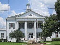 Madison Parish Courthouse in Tallulah | |
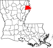 Location in the U.S. state of Louisiana | |
 Louisiana's location in the U.S. | |
| Founded | 1838 |
| Named for | James Madison |
| Seat | Tallulah |
| Largest city | Tallulah |
| Area | |
| • Total | 651 sq mi (1,686 km2) |
| • Land | 624 sq mi (1,616 km2) |
| • Water | 26 sq mi (67 km2), 4.1% |
| Population (est.) | |
| • (2015) | 11,514 |
| • Density | 18.57/sq mi (7.17/km2) |
| Congressional district | 5th |
| Time zone | Central: UTC−6/−5 |
| Website |
madisonparish |


Madison Parish (French: Paroisse de Madison) is a parish located on the northeastern border of the U.S. state of Louisiana, in the delta lowlands along the Mississippi River. As of the 2010 census, the population was 12,093.[1] Its parish seat is Tallulah.[2] The parish was formed in 1839.[3]
With a history of cotton plantations, the parish economy continues to be primarily agricultural. It has a majority African-American population.
History
Prehistory
Madison Parish was the home to many succeeding Native American groups in the thousands of years before European settlement. Peoples of the Marksville culture, Troyville culture, Coles Creek culture and Plaquemine culture built villages and earthwork mound complexes throughout the area. Notable examples include the Fitzhugh Mounds and the Raffman Site.
Historic tribes which were encountered by European colonists include the Taensa and Natchez people, both speaking the Natchez language.
European settlement to present
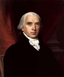
The parish is named for former U.S. President James Madison.[4] As was typical of northern areas of Louisiana, and especially along the Mississippi River, it was developed for cotton agriculture on large plantations worked by enslaved African Americans.
In Madison's honor, the parish courthouse is built in the colonial Virginia style of architecture. It is located in the center of the downtown area and faces east. Nearby is the Tallulah City Hall, which faces south.
During the American Civil War, Madison Parish, then a rich cotton area, sent many of its young white men into battle early in the war. Major planters were excluded from service but sometimes funded the equipping of companies. In 1862, the parish government paid a bonus of $80 to anyone joining one of her Confederate military companies.[5]
When Governor Thomas Overton Moore realized that New Orleans was going to fall to Union forces, he issued orders for the destruction of cotton in the state to keep it from Federal hands. The Union would sell the cotton, for which there was still high demand and claim the revenue. The planters and brokers supervised slaves burning hundreds of thousands of dollars worth of cotton in New Orleans and around the state.[6] Governor Moore asked Brig. Gen. R. B. Todd, who commanded the Eleventh Brigade in northeast Louisiana, to call into active service his own militia and all men between eighteen and forty who were not subject to conscription. These men from Madison, Carroll, and Tensas parishes were to cooperate with Confederate authorities to help repel Federal attacks in the area.[7]
Toward the end of the war, Madison Parish faced problems with jayhawkers, men sympathetic to the Union. According to historian Winters, they "were holed up in the impenetrable cane and cypress swamps in the area. This band, made up of draft dodgers, deserters, and runaway Negroes, often left the swamps to rob, kill, or capture anyone who passed by on the road."[8] The Confederates dressed in Federal uniforms to trick the jayhawkers. Winters continues: "The leader of the desperadoes, a huge black, welcomed the supposed Federal troops. Suddenly the [Confederate] disguised men fell upon the surprised gang and began to slaughter them. [In] a quick but bloody struggle [the Confederates] killed 130 of the group. The few who escaped never again returned to ravage the area."[8]
Following the Reconstruction era and during the Jim Crow era, violent suppression of black voting and civil rights took place across the state. Twelve blacks were lynched in Madison Parish from 1877 to 1950, most near the turn of the 20th century when social and economic tensions were the highest.[9] In addition, in July 1899 five immigrant Sicilian grocers were lynched by whites in Tallulah, the parish seat, for failing to observe Jim Crow customs of serving whites before blacks and because they were competing with locals with their stores.[10]
The Sevier family dominated Madison Parish politics for more than a century. They claimed descent from John Sevier, a fighter in the American Revolution, governor of Tennessee, and namesake of Sevierville and Sevier County in eastern Tennessee. Among the political Seviers were Andrew Jackson Sevier, Jr., who served as sheriff of Madison Parish from 1904 until his death in 1941, when he was briefly succeeded by his wife, Mary Louise Day Sevier. Louisiana State Senator Andrew L. Sevier served from 1932 until his death in 1962, and State Representative Henry Clay "Happy" Sevier, Sr., whose tenure lasted from 1936 to 1952. William Putnam "Buck" Sevier, Jr., was a banker, town alderman, and mayor of Tallulah from 1947 until his retirement in 1974. [11]
Geography
According to the U.S. Census Bureau, the parish has a total area of 651 square miles (1,690 km2), of which 624 square miles (1,620 km2) is land and 26 square miles (67 km2) (4.1%) is water.[12]
Major highways
Adjacent counties and parishes
- East Carroll Parish (north)
- Warren County, Mississippi (east)
- Tensas Parish (south)
- Franklin Parish (southwest)
- Richland Parish (northwest)
National protected areas
Demographics
Because of limited job opportunities as agriculture has mechanized, the parish population has declined overall by about one-third since its peak in 1940. Numerous African Americans left during the first half of the 20th century in the Great Migration to escape the violence and oppression of Jim Crow; they moved to the North and West.
| Historical population | |||
|---|---|---|---|
| Census | Pop. | %± | |
| 1840 | 5,142 | — | |
| 1850 | 8,773 | 70.6% | |
| 1860 | 14,133 | 61.1% | |
| 1870 | 8,600 | −39.1% | |
| 1880 | 13,906 | 61.7% | |
| 1890 | 14,135 | 1.6% | |
| 1900 | 12,322 | −12.8% | |
| 1910 | 10,676 | −13.4% | |
| 1920 | 10,829 | 1.4% | |
| 1930 | 14,829 | 36.9% | |
| 1940 | 18,443 | 24.4% | |
| 1950 | 17,451 | −5.4% | |
| 1960 | 16,444 | −5.8% | |
| 1970 | 15,065 | −8.4% | |
| 1980 | 15,975 | 6.0% | |
| 1990 | 12,463 | −22.0% | |
| 2000 | 13,728 | 10.2% | |
| 2010 | 12,093 | −11.9% | |
| Est. 2016 | 11,528 | [13] | −4.7% |
| U.S. Decennial Census[14] 1790-1960[15] 1900-1990[16] 1990-2000[17] 2010-2013[1] | |||
2010
According to the 2010 U.S. Census, the racial make up was:
- 61.0% Black
- 37.2% White
- 1.6% Hispanic or Latino (of any race)
- 0.2% Native American
- 0.2% Asian
- 0.0% Native Hawaiian or Pacific Islander
- 0.4% Some other race
- 0.9% Two or more races
2000
As of the census[18] of 2000, there were 13,728 people, 4,469 households, and 3,141 families residing in the parish. The population density was 22 people per square mile (8/km²). There were 4,979 housing units at an average density of 8 per square mile (3/km²). The racial makeup of the parish was 60.34% Black or African American, 37.86% White, 0.15% Native American, 0.16% Asian, 0.01% Pacific Islander, 0.35% from other races, and 1.13% from two or more races. 2.10% of the population were Hispanic or Latino of any race.
There were 4,469 households out of which 35.40% had children under the age of 18 living with them, 41.20% were married couples living together, 24.20% had a female householder with no husband present, and 29.70% were non-families. 26.60% of all households were made up of individuals and 11.00% had someone living alone who was 65 years of age or older. The average household size was 2.74 and the average family size was 3.35.
In the parish the population was spread out with 32.60% under the age of 18, 11.20% from 18 to 24, 25.50% from 25 to 44, 19.10% from 45 to 64, and 11.60% who were 65 years of age or older. The median age was 30 years. For every 100 females there were 103.30 males. For every 100 females age 18 and over, there were 95.60 males.
The median income for a household in the parish was $20,509, and the median income for a family was $23,589. Males had a median income of $26,394 versus $16,141 for females. The per capita income for the parish was $10,114. About 29.70% of families and 36.70% of the population were below the poverty line, including 51.60% of those under age 18 and 22.00% of those age 65 or over. The parish's per-capita income makes it one of the poorest places in the United States.
Politics
With its majority-black population, Madison Parish in the 21st century has become a stronghold of support for the Democratic Party. Prior to the passage of the Voting Rights Act of 1965, when the state unconstitutionally prevented blacks from voting, the white Madison Parish voters in 1962 supported the Republican nominee Taylor W. O'Hearn for the US Senate; he lost to powerful Democratic incumbent Russell B. Long. O'Hearn polled 58.7 percent among whites in Madison Parish. [19] He later was elected to the Louisiana House of Representatives from Caddo Parish, also in the northern part of the state.
During the 1970s and 1980s, conservative white voters in Louisiana and other southern states began to shift to supporting Republican presidential candidates, creating a more competitive system than the Solid South. Since the civil rights era, most African Americans in the South have supported Democratic candidates, as the national party supported their drive to exercise constitutional rights as citizens. In 1988, Governor Michael Dukakis of Massachusetts won in Madison Parish, with 2,416 votes (49.2 percent) compared to Republican Vice President George H.W. Bush, who finished in the presidential contest with 2,334 ballots (47.5 percent).[20]
In 2008, the Democrat Barack Obama of Illinois received 3,100 votes (58.5 percent) in Madison Parish to 2,152 (40.6 percent) for the Republican U.S. Senator John McCain of Arizona.[21] In 2012, Madison Parish gave President Obama 3,154 votes (60.8 percent) to Mitt Romney's 2,000 ballots (38.6 percent), 152 fewer votes than McCain had received four years earlier.[22]
| Year | Republican | Democratic | Third parties |
|---|---|---|---|
| 2016 | 40.7% 1,927 | 58.0% 2,744 | 1.3% 61 |
| 2012 | 38.6% 2,000 | 60.8% 3,154 | 0.6% 33 |
| 2008 | 40.6% 2,152 | 58.5% 3,100 | 0.9% 48 |
| 2004 | 49.0% 2,291 | 50.0% 2,334 | 1.0% 48 |
| 2000 | 44.9% 2,127 | 52.5% 2,489 | 2.7% 127 |
| 1996 | 31.4% 1,591 | 60.9% 3,085 | 7.7% 389 |
| 1992 | 33.3% 1,702 | 54.3% 2,773 | 12.4% 631 |
| 1988 | 47.5% 2,334 | 49.2% 2,416 | 3.3% 161 |
| 1984 | 48.6% 2,849 | 49.6% 2,906 | 1.9% 109 |
| 1980 | 42.7% 2,531 | 55.1% 3,264 | 2.2% 133 |
| 1976 | 29.4% 2,096 | 69.2% 4,933 | 1.4% 99 |
| 1972 | 49.2% 2,420 | 45.7% 2,249 | 5.0% 248 |
| 1968 | 11.4% 649 | 46.8% 2,659 | 41.8% 2,380 |
| 1964 | 83.2% 2,061 | 16.8% 417 | |
| 1960 | 33.3% 629 | 12.5% 235 | 54.2% 1,024 |
| 1956 | 27.3% 461 | 16.3% 276 | 56.4% 955 |
| 1952 | 64.3% 1,253 | 35.7% 695 | |
| 1948 | 9.3% 127 | 14.4% 197 | 76.3% 1,042 |
| 1944 | 30.7% 338 | 69.3% 764 | |
| 1940 | 15.2% 182 | 84.8% 1,017 | |
| 1936 | 6.1% 71 | 93.9% 1,085 | |
| 1932 | 10.9% 67 | 89.1% 548 | |
| 1928 | 32.2% 151 | 67.8% 318 | |
| 1924 | 4.5% 13 | 95.5% 274 | |
| 1920 | 1.2% 4 | 98.8% 331 | |
| 1916 | 0.5% 1 | 99.5% 187 | |
| 1912 | 0.0% 0 | 95.4% 146 | 4.6% 7 |
Education
Public schools in Madison Parish are operated by the Madison Parish School Board.
Corrections
The Lasalle Management office operates the Madison Parish Correctional Center and Louisiana Correction Transitional Center for Women in Tallulah.
Communities

Cities
- Tallulah (parish seat)
Villages
See also
References
- 1 2 "State & County QuickFacts". United States Census Bureau. Archived from the original on July 14, 2011. Retrieved August 10, 2013.
- ↑ "Find a County". National Association of Counties. Retrieved 2011-06-07.
- ↑ "Madison Parish". Center for Cultural and Eco-Tourism. Retrieved September 5, 2014.
- ↑ Gannett, Henry (1905). The Origin of Certain Place Names in the United States. U.S. Government Printing Office. p. 196.
- ↑ John D. Winters, The Civil War in Louisiana, Baton Rouge: Louisiana State University Press, 1963, ISBN 0-8071-0834-0, p. 74
- ↑ Winters, p. 103
- ↑ Winters, p. 165
- 1 2 Winters, p. 394
- ↑ Lynching in America, Third Edition: Supplement by County, p. 6, Equal Justice Initiative, Mobile, AL, 2017
- ↑ Ken Scambray, " 'Corda e Sapone' (Rope and Soap): how the Italians were lynched in the USA", L'Italo-Americano, 13 December 2012; accessed 14 May 2018
- ↑ "Sevier Family of Madison Parish, Louisiana". rootsweb.ancestry.com. Retrieved February 15, 2011.
- ↑ "2010 Census Gazetteer Files". United States Census Bureau. August 22, 2012. Archived from the original on September 28, 2013. Retrieved September 1, 2014.
- ↑ "Population and Housing Unit Estimates". Retrieved June 9, 2017.
- ↑ "U.S. Decennial Census". United States Census Bureau. Retrieved September 1, 2014.
- ↑ "Historical Census Browser". University of Virginia Library. Retrieved September 1, 2014.
- ↑ "Population of Counties by Decennial Census: 1900 to 1990". United States Census Bureau. Retrieved September 1, 2014.
- ↑ "Census 2000 PHC-T-4. Ranking Tables for Counties: 1990 and 2000" (PDF). United States Census Bureau. Retrieved September 1, 2014.
- ↑ "American FactFinder". United States Census Bureau. Retrieved 2008-01-31.
- ↑ Louisiana Secretary of State, General election returns, 6 November 1962
- ↑ "Madison Parish presidential election returns, November 8, 1988". staticresults.sos.la.gov. Retrieved November 19, 2012.
- ↑ "Madison Parish presidential election returns, November 4, 2008". staticresults.sos.la.gov. Retrieved November 19, 2012.
- ↑ "Madison Parish presidential election returns, November 6, 2012". staticresults.sos.la.gov. Retrieved November 19, 2012.
- ↑ Leip, David. "Dave Leip's Atlas of U.S. Presidential Elections". uselectionatlas.org. Retrieved 2018-03-07.
External links
Places adjacent to Madison Parish, Louisiana | ||||||||||
|---|---|---|---|---|---|---|---|---|---|---|
| ||||||||||
Municipalities and communities of Madison Parish, Louisiana, United States | ||
|---|---|---|
| Cities | | |
| Villages | ||
| Unincorporated communities | ||