Haleakalā National Park
| Haleakalā National Park | |
|---|---|
|
IUCN category II (national park) | |
.jpg) | |
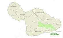
 Location within Hawaii | |
| Location | Maui County, Hawaii, United States |
| Nearest city | Pukalani |
| Coordinates | 20°43′0″N 156°10′0″W / 20.71667°N 156.16667°WCoordinates: 20°43′0″N 156°10′0″W / 20.71667°N 156.16667°W |
| Area | 33,265 acres (134.62 km2)[1] |
| Established | July 1, 1961 |
| Visitors | 1,112,390 (in 2017)[2] |
| Governing body | National Park Service |
| Website |
Official website |
Haleakalā National Park is an American national park located on the island of Maui in the state of Hawaii. The park covers an area of 33,265 acres (134.62 km2),[1] of which 19,270 acres (77.98 km2) is a wilderness area.[3]
History
It was originally created as part of the Hawaii National Park along with the volcanoes of Mauna Loa and Kilauea on the island of Hawaiʻi in 1916. Hawaiʻi Volcanoes National Park was made into a separate national park in 1961. The park area was designated an International Biosphere Reserve in 1980.[4] The name Haleakalā is Hawaiian for "house of the sun." According to a local legend, the demigod Maui imprisoned the sun here in order to lengthen the day.[5] The Hawaiian National Park Language Correction Act of 2000 was proposed to observe the Hawaiian spelling, but it did not become law.[6]
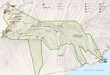
The park features the dormant Haleakalā (East Maui) Volcano, which last erupted sometime between 1480 and 1600 AD.[7] The park is divided into two distinct sections: the summit area and the coastal Kipahulu area.
Haleakala National Park superintendents:[8]
- 1961—1963 — John W. Stratton
- 1963—1967 — Neal G. Guse
- 1967—1969 — Forrest M. Benson, Jr.
- 1969—1970 — Lynn H. Thompson
- 1971—1974 — Russell Cahill
- 1974—1987 — Hugo H. Huntzinger
- 1987—1988 — Peter G. Sanchez
- 1988— 2018 — Donald W. Reeser
Summit
.jpg)
An extremely winding but well maintained road leads up the mountain. The summit area includes Haleakalā Crater, the summit of the volcano, and the area surrounding the summit. This part of the park is accessed by Hawaii state road 378. There is a visitor center, with parking and restrooms, near the summit. At the summit itself is another parking lot and a simple observatory without facilities.
The main feature of this part of the park is undoubtedly the famous Haleakalā Crater. It is huge: 6.99 miles (11.25 km) across, 2.0 mi (3.2 km) wide, and some 2,600 ft (790 m) deep. The interior of the crater is dotted by numerous volcanic features, including large cinder cones. Two main trails lead into the crater from the summit area: the Halemau'u and Sliding Sands trails. Hikers in the crater can stay in one of three cabins (which need to be reserved through the park first).
Each morning, visitors come to the summit of the volcano to watch the spectacular sunrise. More visitors come each afternoon to watch the equally amazing sunset. In either case conditions can be extremely cold. One attraction of the park is Hosmer's Grove, a unique forest of alien trees including deodar (Cedrus deodara) from the Himalayas, sugi (Cryptomeria japonica) from Japan, eucalyptus from Australia, and several species from North America (pine, spruce, cypress, fir, and others). Native plants and trees are also present in the forest but are not very common due to the little light available (because of the taller alien trees).
The park is known for its unique volcanic features, its long scenic drive with numerous overlooks, and the unusually clear views of the night sky available. Haleakalā is one of the best places in the United States for amateur astronomy, and binoculars and telescopes are available for rent from many local merchants. Nēnē (Hawaiian geese, Branta sandvicensis) can also be seen in their natural habitat in Haleakalā Crater. Although nēnē died out entirely in the park, in 1946 they were re-introduced with the help of the Boy Scouts, who carried young birds into the crater in their backpacks.[9]
Kipahulu

The second section of the park is the Kipahulu section. Visitors cannot drive directly to this section from the summit area; they must take a winding coastal road that travels around the windward coast of the island. This part of the park lies within the lower part of Kipahulu Valley. It is separated from the summit area of the park by the upper portion of the valley. This area is designated the Kipahulu Valley Biological Reserve and is closed to the public to preserve the native plant and animal species in this fragile rainforest.
This section of the park features more than two dozen pools along Palikea Stream in the gulch called ʻOheʻo. These pools contain rare native freshwater fish. Visitors may choose to swim in these pools, or they may choose to hike a trail that takes visitors up to the base of Waimoku Falls.
Flora and fauna
Due to Hawaii's volcanic origin and isolation, all of the native plants and animals on all the islands evolved from pioneers, which arrived carried by the wind, waves or wings of birds or arrived themselves naturally the same way. Before the arrival of humans, a new species arrived in Hawaii every 10,000 to 100,000 years. Eventually, they evolve into endemic species, unique to the islands. More endangered species live in Haleakalā National Park than any other national park in the United States.[10] Once traveling to this part of the island became more frequent, native species were destroyed. One example is the ʻāhinahina (Haleakalā silversword, Argyroxiphium sandwicense macrocephalum), which used to cover Haleakala Mountain to a degree where the mountain looked as if it were covered with snow.[11] Other endangered species include the endangered Haleakalā schiedea (Schiedea haleakalensis).[12]
The park is home to many tardigrade (water bear) species surviving in the extreme environment near the mountain summit. In the 1980s, local biologist Sam Gon III discovered 31 tardigrade species here and considers Haleakalā the "richest place on Earth for tardigrades".[13]
Haleakala Observatory
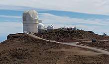
Haleakala Observatory is an important observation site located near the visitor center. It is above the tropical inversion layer and so experiences excellent viewing conditions and very clear skies. For over 40 years, the University of Hawaii Institute for Astronomy has managed this site, conducting dedicated astrophysical experiments. Due to the aforementioned location of the observatory, most of these programs could not be accomplished anywhere else in the world. One of its missions, the Maui Space Surveillance System (MSSS), is to track satellites and debris orbiting the Earth. The buildings are on a gated road just past the summit.[14]
See also
References
- 1 2 "Listing of acreage as of December 31, 2011". Land Resource Division, National Park Service. Retrieved 2012-03-07.
- ↑ "NPS Annual Recreation Visits Report". National Park Service. Retrieved 2018-02-26.
- ↑ "The National Parks: Index 2009–2011". National Park Service. Retrieved 2012-03-07.
- ↑ "Biosphere Reserve Information: United States of America: Hawaiian Islands". United Nations Educational, Scientific and Cultural Organization. Retrieved 2009-12-02.
- ↑ Westervelt, WD (1910). "Legends of Maui: A Demi-God of Polynesia and His Mother Hina". sacred-texts.com. Retrieved 2012-03-14.
- ↑ Hawaiian National Park Language Correction Act of 2000 (S.939)
- ↑ "Youngest lava flows on East Maui probably older than A.D. 1790". 1999-10-04. Retrieved 2012-03-14.
- ↑ Historic Listing of National Park Service Officials: Superintendents of National Park System Areas, Hawaii. Last Modified: 2000.
- ↑ Hurley, Timothy (2002-07-13). "Maui's Boy Scouts mark 40-year link to nene". Honolulu Advertiser. Retrieved 2012-03-14.
- ↑ "Issues". Friends of Haleakala National Park. Retrieved 2009-03-07.
- ↑ "Silverswords of Hawaii". Hawaii Guide. Retrieved 2012-03-14.
- ↑ Shiedea haleakalensis. The Nature Conservancy.
- ↑ Wianecki, Shannon (2016-08-21). "Hawaii's mysterious water bears". BBC. Retrieved 2016-09-11.
- ↑ Maui Space Surveillance Site (MSSS)
External links
- Haleakalā National Park – National Park Service
- Friends of Haleakala National Park – nonprofit organization
- Haleakalā Biosphere Reserve (archive) – UNESCO website
- East Maui Watershed Partnership – nonprofit organization for cultural interpretation and restoration in Kipahulu district of Haleakala National Park
- "Haleakalā National Park". Geographic Names Information System. United States Geological Survey. Retrieved 2011-08-19.
- Historic American Engineering Record (HAER) No. HI-52, "Haleakala National Park Roads, Pukalani, Maui County, HI", 177 photos, 4 color transparencies, 106 data pages, 22 photo caption pages
Hawaiian volcanism topics (list) | ||
|---|---|---|
| Windward Isles | 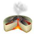 | |
| Leeward Isles | ||
| Emperor Seamounts | ||
| Notable eruptions and vents | ||
| Topics | ||