Iao Valley
| Iao Valley | |
|---|---|
| ʻĪao Valley | |
 | |
 ʻĪao Valley  ʻĪao Valley ʻĪao Valley (Hawaii) | |
| Floor elevation | 1,000 feet (300 m) |
| Geography | |
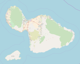
| Coordinates | 20°52′51″N 156°32′42″W / 20.88083°N 156.54500°WCoordinates: 20°52′51″N 156°32′42″W / 20.88083°N 156.54500°W |
| Designations | |
|---|---|
| Designated | 1972 |
.jpg)
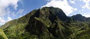
Iao Valley (Hawaiian: ʻĪ-ao: "cloud supreme", pronounced similar to "EE-ow") is a lush, stream-cut valley in West Maui, Hawaii, located 5 kilometres (3.1 mi) west of Wailuku. Because of its natural environment and history, it has become a tourist location. It was designated a National Natural Landmark in 1972.[1]
Iao Valley State Monument
The state park is located on 6.2 acres (2.5 ha) at the end of Iao Valley Road (Highway 32). The Iao Needle (Kūkaemoku) is a famous landmark in the state park, a vegetation-covered lava remnant rising 1,200 feet (370 m) from the valley floor or 2,250 feet (690 m) when measured from sea level. The "needle" itself is an illusion, and is in reality a sharp ridge that gives the appearance of being a spire when viewed end-on.[2] The needle is an extension of and surrounded by the cliffs of the West Maui Mountains, an extinct volcano. One can take a short trail (Iao Needle Lookout Trail and Ethnobotanical Loop) to a windy overlook. Park hours vary depending on season. Visit http://dlnr.hawaii.gov/dsp/parks/maui/iao-valley-state-monument/ for specific hours of operation. [3]
Rainforest
Iao Valley is covered in dense rainforest, most of which consists of introduced vegetation on the valley floor. The Puʻu Kukui summit area at the valley's head receives an average 386 inches (9.8 m) of rainfall per year,[4] making it the state's second wettest location after The Big Bog, slightly wetter than Mount Waiʻaleʻale.[5] Much of this rainfall ends up flowing into the Iao Stream. Trails in the State Park run alongside Iao Stream and through the forest.
History
The Hawaiian god Kāne is considered to be the procreator and the provider of life. He is associated with wai (fresh water) as well as clouds, rain, streams, and springs. Kanaloa, the Hawaiian god of the underworld, is represented by the phallic stone of the Iao Needle.
Kapawa, the king of Hawaiʻi prior to Pili, was buried here. Maui's ruler Kakaʻe, in the late 15th century, designated Iao Valley as an aliʻi burial ground. The remains were buried in secret places. In 1790, the Battle of Kepaniwai took place there, in which Kamehameha the Great defeated Kalanikūpule and the Maui army during his campaign to unify the islands. The battle was said to be so bloody that dead bodies blocked Iao Stream, and the battle site was named Kepaniwai ("the damming of the waters").
20th Century Fox's 1997 motion picture Turbo: A Power Rangers Movie was partially filmed here.
Kepaniwai Park's Heritage Gardens
Since 1952, Kepaniwai Park's Heritage Gardens have memorialized Maui's multicultural history. Scale models of ethnic buildings and gardens representing the immigration of Hawaiian, American missionary, Chinese, Japanese, Portuguese, Korean, and Filipino cultures are the park's highlight. The gardens were restored in 1994.[6] The Hawaii nature center is located just outside the gardens, which provides access to a museum and children's education about Hawaii and conservation.[7]
References
- ↑ "I'ao Valley". National Natural Landmark. National Park Service. Archived from the original on 2011-10-16. Retrieved 12 December 2012.
- ↑ "The trail of the Ancients - the Iao Needle effect". Waialeale Base Camp. Retrieved 2012-10-30.
- ↑ "Iao Valley State Monument". Hawaii State Parks; Maui. Department of Land and Natural Resources. Archived from the original on 2009-05-24. Retrieved 2009-03-14.
- ↑ "NOAA Hawaiʻi rain gauge summary". Pacific Islands Water Science Center. United States Geological Survey. Retrieved 2009-02-20.
- ↑ "May 2010 Precipitation Summary". National Weather Service Forecast Office Honolulu, HI. National Oceanic and Atmospheric Administration. June 7, 2010. Retrieved 2010-11-15.
Most of the gages in Maui County had below normal totals for 2010 through the end of May. Puu Kukui’s 99.90 inches (57 percent of normal) led all totals county wide and ranked second highest in the state.
- ↑ Kepler, Angela Kay (2007). West Maui: A Natural History Guide (1st ed.). Mutual Publishing. ISBN 1-56647-823-5.
- ↑ "Hawaii Nature Center". Retrieved April 12, 2013.
Further reading
| Wikimedia Commons has media related to: |
- Kyselka, Will; Ray E. Lanterman (1980). Maui: How it Came to Be. Honolulu: University of Hawaii Press. ISBN 0-8248-0530-5.