Virgin Islands National Park
| Virgin Islands National Park | |
|---|---|
|
IUCN category V (protected landscape/seascape) | |
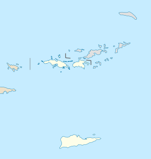 | |
| Location | United States Virgin Islands |
| Nearest city | Charlotte Amalie |
| Coordinates | 18°20′0″N 64°44′0″W / 18.33333°N 64.73333°WCoordinates: 18°20′0″N 64°44′0″W / 18.33333°N 64.73333°W |
| Area | 14,737 acres (59.64 km2)[1] |
| Established | August 2, 1956 |
| Visitors | 304,408 (in 2017)[2] |
| Governing body | National Park Service |
| Website | Virgin Islands National Park |
The Virgin Islands National Park is a United States National Park, covering approximately 60% of the island of Saint John in the United States Virgin Islands, over 5,500 acres of adjacent ocean, plus nearly all of Hassel Island, just off the Charlotte Amalie, Saint Thomas harbor. It became the 29th U.S. national park in 1956.
The park is famous for scuba diving and snorkeling and has miles of hiking trails through the tropical rainforest.
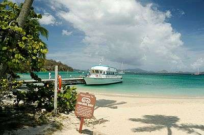
Cruz Bay is the gateway port to the park. Ferries operate hourly from Red Hook, St. Thomas, thrice daily from Charlotte Amalie, St. Thomas and West End, Tortola, twice daily from Jost Van Dyke, and twice weekly from Virgin Gorda.[3]
The Virgin Islands National Park Visitor Center is located in Cruz Bay. It contains restrooms, maps and information, an outdoor picnic area, a dock, and a gift shop.
The park had an average of over 450,000 visitors per year in the period from 2007 to 2016.[2]
Park history
`In 1956, Laurance Rockefeller's Jackson Hole Preserve donated its extensive lands on the island to the United States' National Park Service, under the condition that the lands had to be protected from future development. The remaining portion, the Caneel Bay Resort, operates on a lease arrangement with the NPS, which owns the underlying land.
The boundaries of the Virgin Islands National Park include 75% of the island, but various in-holdings within the park boundary (e.g., Peter Bay, Maho Bay) reduce the park lands to 60% of the island acreage.
Much of the island's waters, coral reefs, and shoreline have been protected by being included in the national park. This protection was expanded in 2001, when the Virgin Islands Coral Reef National Monument was created.
In 2006, The Trust for Public Land purchased Estate Maho Bay a 415 acres property for preservation.[4] The property includes beaches, undisturbed forest as well as historic Danish colonial and Taino Indian artifacts.[4] As funds become available the property will be sold to the National Park Service.[5] In 2011, The Trust for Public Land donated 18 acres at Mamey's peak to the National Park Service.[6] In 2012, the National Park Service purchased 58 acres from The Trust for Public Land for $2.25 million from the federal Land and Water Conservation Fund.[7][8] In 2013, an additional 72 acres of the Estate Maho Bay property was sold to the National Park service for $2.5 million, the largest addition to the park.[9]
Attractions
Beaches, coral reefs, hiking trails, and natural sites are the park's main attractions.
The park is free to enter and the only fee is at Trunk Bay Beach, which charges admission for adults. Overnight and day use mooring balls are available to boaters, for a mooring and anchoring fee.
Visitors can stay in numerous resorts, hotels, and vacation villas near the park on St. John. Cinnamon Bay Campground is located inside the park, as is Caneel Bay resort on the north shore which lies on Rockefeller's former personal estate.
Safari taxis are available in Cruz Bay and at the most popular National Park beaches along the north shore. Note that taxi prices are per person in the Virgin Islands.
Beaches
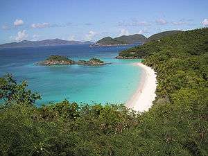
The beaches of Virgin Islands National Park are regularly named some of the best in the world. The most popular beaches are Trunk Bay, Cinnamon Bay, Honeymoon Beach, Hawksnest Bay, Maho Bay, and Salt Pond Bay.
Trunk Bay
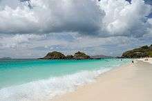
Trunk Bay is a body of water and a beach on Saint John in the United States Virgin Islands. It has consistently been voted one of the Ten Best Beaches in The World by Condé Nast Traveler magazine and has received similar recognition from other publications.[10] Amenities include a snack bar, showers and restrooms, lifeguards, and an underwater trail for snorkeling its coral reef.[10][11] The beach area is divided into two halves, the main Trunk Bay beach and swim area and Burgesman Cove which is located on the west end of Trunk Bay near Jumbie Bay. Trunk Bay is the only National Park beach on Saint John which requires a fee to visit. Parking is limited at Trunk Bay, but taxis from Cruz Bay are readily available.[12]
Cinnamon Bay
Cinnamon Bay beach is a long, wide stretch of sand on the north shore of St. John. The beach is popular for sunbathing, snorkeling, and water sports. The New York Times named Cinnamon Bay one of the "6 Caribbean Beaches to See Before You Die."[13] The bay is also home to the Cinnamon Bay Campground, a restaurant, sundries shop, and water sports rental.[14]
Honeymoon Beach

Honeymoon Beach is on the north shore of St. John and can be accessed from Cruz Bay by hiking the one mile long Lind Point Trail or from Caneel Bay Resort. Condé Nast Traveler named Honeymoon Beach one of the "Top 10 Island Beaches for Unplugging."[15] The beach features soft white sand under tall palm trees. There are kayak, snorkel equipment, and beach chair rentals available.
Maho Bay
Maho Bay is known for its soft sand and calm, shallow waters. The sand and seagrass sea floor make it a good place to see sea turtles and stingrays. Harper's Bazaar named Maho Bay one of the best beaches in the world.[16]
Salt Pond Bay
Located on St. John's south shore, Salt Pond Bay is a protected bay and beach. The beach can be reached by hiking a short trail from Route 107, about 4 miles south of Coral Bay. The bay is a popular snorkeling spot and has fringing reefs on both sides of the bay, sea grass in the center, and a deep coral reef far out in the middle of the bay. Overnight and day use mooring balls are available for boaters. From Salt Pond Bay, hikers can access Drunk Bay and Ram Head Trail. USA Today called Salt Pond Bay one of the best in the Virgin Islands.[17]
Hiking
The park includes the sugar-plantation-ruins-littered Cinnamon Bay Nature Trail and the Bordeaux Mountain Trail that leads to the highest point on the island at 1,277 feet (389 m) above sea level.
Reef Bay Trail
The most popular hike is the Reef Bay Trail. This route paves the way to witnessing the beauty of the surrounding forestlands, remnants of sugar mills, historical Taíno petroglyph rock carvings,[18] a spring-fed waterfall and reflection pool, and a chance for rest and relaxation or snorkeling excitement at Genti Bay. The hike is strenuous and the round trip from Centerline Road is over 6 miles. The National Park offers a ranger guided hike that includes a boat ride back to Cruz Bay from the bottom of Reef Bay.
Bordeaux Mountain Trail
The Bordeaux Mountain trail is a steep and rocky path leading from Little Lameshur Bay to the highest point of the island. The trail is unmaintained and although there are several overlooks along the way, there is no view from the top of this densely forested mountain. The trail gains almost 1,300 feet of elevation in about one mile.
Lind Point Trail
The one mile long Lind Point Trail begins in Cruz Bay, behind the Virgin Islands National Park Visitors Center. It climbs up to Lind Point, overlooking Cruz Bay harbor, before continuing on to Honeymoon Beach.
Caneel Hill Trail
Starting in Cruz Bay, just north of Mongoose Junction, the Caneel Hill Trail travels up a steep incline to the top of Caneel Hill. There is a wooden observation platform at the top with views of St. John, St. Thomas, Jost Van Dyke, and many smaller islands. On a clear day, it's possible to see St. Croix and even Puerto Rico.
Ram Head Trail
Beginning at Salt Pond Bay, the Ram Head Trail travels about one mile down a dry and rocky peninsula to the southernmost point on St. John.
Cinnamon Bay Nature Trail and Accessible Boardwalk
Across from the entrance to Cinnamon Bay Campground, the Cinnamon Bay Nature Trail is a half mile loop winding through the ruins of a sugar factory. Signs along the path explain the history of the area. The trail is a mixture of boardwalks and paved paths with no steep hills.
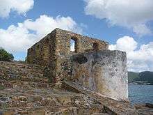
Historic Sites
The park is littered with dozens of historic ruins from the colonial and plantation eras through the 1950s.
Annaberg Historic District
The Annaberg plantation is a partially restored sugar factory and windmill located just east of Mary's Point. National Park signage guides visitors through the ruins and explains the process of turning sugar cane into molasses. Volunteers and park rangers are frequently in the area to answer questions. The bake house hosts cooking demonstrations and offers samples of dumb bread. The windmill is located on Annaberg Point, which offers views of Tortola, Great Thatch Island, and the Narrows.
Reef Bay Sugar Factory Historic District
The ruins of the Reef Bay sugar factory can be reached via Reef Bay Trail or L'Esperance trail.
Petroglyph Site
The Reef Bay Trail petroglyphs are Taino rock carvings located on rock pools near a waterfall. They can be reached via a quarter mile long spur trail from Reef Bay Trail. The Petroglyph site was added to the National Register of Historic Places in 1982.
Catherineberg Sugar Mill Ruins
The well preserved ruins of the Catherineberg sugar mill are some of the most easily accessed in the park. From Centerline Road, turn onto John Head Road and park right next to the sugar mill.
Geography

Virgin Islands National Park is spread out on 14,737 acres (5,964 ha) of land. The park covers almost 60 percent of St. John Island, adjacent ocean, and almost all of Hassel Island.
Features
The main features of the Virgin Islands National Park are the coral reefs and oceans. They almost completely surround the park. Another important feature of the Virgin Islands are the tropical forests. Wild donkeys, deer, mongoose, pigs, goats, birds, iguanas, skinks, tortoise, frogs, and crabs are common seen. Bats are the only land mammal native to the park.
Climate
The Virgin Islands National Park has a tropical savannah climate. The average rainfall per year is 55 inches (1,400 mm). In the winter, trade winds blow from 11 to 21 knots (39 km/h). The average temperature for the park is 79 °F (26 °C). At the Virgin Islands, the dominant plant species are dry tropical forest plants.
- Seasonality
There is very little temperature difference between summer and winter and the sea is warm year round. The tourist season is from December to April and outside of those months prices for accommodations drop considerably. Camping and rustic lodging are available in the park from November through August at Cinnamon Bay Campground. Caneel Bay Resort provides luxury accommodations along with upscale dining in the park from November through July.
Geology
Located at the east end of the Greater Antilles, St. John resides on the northeastern end of the Caribbean Plate. The island formed during the Cretaceous with the eruption of the Water Island Formation, consisting of keratophyres and pillow basalts. Igneous activity then changed to that of an island arc, characterized by the Louisenhoj Formation, consisting of andesite and basalt. Volcanism abated during the deposition of the Outer Brass Limestone. Volcanism resumed as evidenced by the Late Cretaceous Tutu Formation, consisting of volcaniclastic turbidites, basalt, and andesite. A diabase dike swarm followed and then compressive folding attributed to the Caribbean Plate colliding with the Bahama Platform. The Late Eocene saw the intrusion of Narrows pluton and Virgin Gorda batholith, associated with the Greater Antilles arc magmatism, and more compressive folding associated with the spreading of the Cayman Trough. This spreading is also tied to sinistral strike-slip faulting at 39 Ma.[19]
References
- ↑ "Listing of acreage as of December 31, 2011". Land Resource Division, National Park Service. Retrieved 2012-03-07.
- 1 2 "NPS Annual Recreation Visits Report". National Park Service. Retrieved 2018-03-01.
- ↑ "Virgin Islands Ferry Schedules". Retrieved 2016-09-08.
- 1 2 "415 Acres To be Added to Virgin Islands National Park". The Trust for Public Land. Retrieved 2018-08-09.
- ↑ "NPS Purchases 58 Acres of Estate Maho Bay from Trust for Public Land - St. John Tradewinds News". St. John Tradewinds News. 2012-05-01. Retrieved 2018-08-09.
- ↑ "Estate Maho Bay, St. John". The Trust for Public Land. Retrieved 2018-08-09.
- ↑ "NPS Purchases 58 Acres of Estate Maho Bay from Trust for Public Land - St. John Tradewinds News". St. John Tradewinds News. 2012-05-01. Retrieved 2018-08-09.
- ↑ "National Park Service Press Release (U.S. National Park Service)". www.nps.gov. Retrieved 2018-08-09.
- ↑ "Trust for Public Land Sells Final 72 Acres of Estate Maho Bay to National Park Service for $2.5M - St. John Tradewinds News". St. John Tradewinds News. 2013-12-24. Retrieved 2018-08-09.
- 1 2 "Places to Go". Retrieved 7 March 2011.
- ↑ Scheffel, Richard L.; Wernet, Susan J., eds. (1980). Natural Wonders of the World. United States of America: Reader's Digest Association, Inc. p. 406. ISBN 0-89577-087-3.
- ↑ "St. John: Taxis & Rates - Virgin Islands". Retrieved 2016-09-08.
- ↑ Peters, Jeremy W. (2010-11-04). "6 Caribbean Beaches to See Before You Die". The New York Times. ISSN 0362-4331. Retrieved 2016-09-10.
- ↑ pixelbeachstudio.com. "Cinnamon Bay Campground, St. John, U.S. Virgin Islands". www.cinnamonbay.com. Archived from the original on 2016-09-13. Retrieved 2016-09-10.
- ↑ "10 Most Relaxing Beaches in the World". 2015-02-23. Retrieved 2016-09-10.
- ↑ "The Best Beaches in The World". 2016-05-03. Retrieved 2016-09-10.
- ↑ "The Best Beaches in the U.S. Virgin Islands". Retrieved 2016-09-12.
- ↑ Singer, Gerald (2006). "St. John USVI Trails: Petroglyphs Trail". St. John Off The Beaten Track. Retrieved 4 November 2012.
- ↑ Rankin, Douglas W. (2002). Geology of St. John, U.S. Virgin Islands, USGS Professional Paper 1631. Washington: United States Government Printing Office. pp. 1–30.
External links
- NPS: official Virgin Islands National Park website
- NPS Virgin Islands National Park — map
- NPS: geology of Virgin Islands National Park
- The short film Saint John, Virgin Islands National Park (1990) is available for free download at the Internet Archive
Charlotte Amalie (capital) | |
| Topics |
|
| Government | |
| Cities | |
| Islands | |
| Parks | |