Koʻolau Range
| Koʻolau Range | |
|---|---|
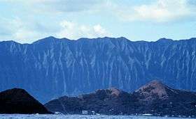 View of Koʻolau Range from offshore Lanikai (windward coast) | |
| Highest point | |
| Peak | Konahuanui |
| Elevation | 3,150 ft (960 m) [1] |
| Prominence | 2,303 ft (702 m) [2] |
| Coordinates | 21°27′0″N 157°54′0″W / 21.45000°N 157.90000°WCoordinates: 21°27′0″N 157°54′0″W / 21.45000°N 157.90000°W |
| Geography | |
 Koʻolau Range Hawaiian Islands | |
| Location | Oahu, Hawaii, US |
| Parent range | Hawaiian Islands |
| Topo map | USGS Kilohana (HI) |
| Geology | |
| Age of rock | 1.7 Ma |
| Mountain type | Dormant shield volcano |
| Volcanic arc/belt | Hawaiian-Emperor seamount chain |
| Last eruption | 32,000 - 10,000 BP |
| Climbing | |
| Easiest route | trail |
| Designated | 1972 |
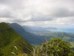
Koʻolau Range is a name given to the dormant fragmented remnant of the eastern or windward shield volcano of the Hawaiian island of Oʻahu. It was designated a National Natural Landmark in 1972.[3]
Geology
It is not a mountain range in the normal sense, because it was formed as a single mountain called Koʻolau Volcano (koʻolau means "windward" in Hawaiian, cognate of the toponym Tokelau). What remains of Koʻolau is the western half of the original volcano that was destroyed in prehistoric times when the entire eastern half—including much of the summit caldera—slid cataclysmically into the Pacific Ocean. Remains of this ancient volcano lie as massive fragments strewn nearly 100 miles (160 km) over the ocean floor to the northeast of Oʻahu. Kāneʻohe Bay is what remains of the ancient volcano's summit caldera after the slide. The modern Koʻolau mountain forms Oʻahu's windward coast and rises behind the leeward coast city of Honolulu — on its leeward slopes and valleys are located most of Honolulu's residential neighborhoods.
The volcano is thought to have first erupted on the ocean floor more than 2.5 million years ago. It eventually reached sea level and continued to grow in elevation until about 1.7 million years ago, when the volcano became dormant. The volcano remained dormant for hundreds of thousands of years, during which time erosion ate away at the initially smooth slopes of the shield-shaped mountain; and the entire mass subsided considerably. The highest elevation perhaps exceeded 3,000 meters (9,800 ft); today, the summit of the tallest peak, Puʻu Konahuanui is only 945 meters (3,100 ft).
After hundreds of thousands of years of dormancy, Koʻolau volcano began to erupt again. Some thirty eruptions over the past 500,000 years or so have created many of the landmarks around eastern Oʻahu, such as Diamond Head, Koko Head (Hanauma Bay), Koko Crater, Punchbowl Crater, Tantalus, and Āliapaʻakai, and are collectively known as the Honolulu Volcanic Series.[4] Geologists do not always agree on the dates of these more recent eruptions, some dating them to around 32,000 years ago, others to as recently as 10,000 years ago. Geologists believe that there is at least a remote possibility that Koʻolau volcano will erupt again.
Transportation
There are three roads that tunnel through the southern part of the Koʻolau Range, connecting Honolulu to the Windward Coast. From leeward to windward:
- Hawaii Route 61 (Pali Highway)
- Hawaii Route 63 (Likelike Highway)
- Interstate H-3
Gallery

References
- ↑ "Koolau Range". Peakbagger.
- ↑ "Konahuanui". Peakbagger.
- ↑ "National Natural Landmark". National Park Service. Retrieved 12 December 2012.
- ↑ "Xenoliths in the Honolulu Volcanic Series, Hawaii". Oxford University Press. 3 February 1970. Retrieved 2014-09-25.
Hawaiian volcanism topics (list) | ||
|---|---|---|
| Windward Isles | 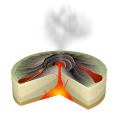 | |
| Leeward Isles | ||
| Emperor Seamounts | ||
| Notable eruptions and vents | ||
| Topics | ||