Hafford
| Hafford, Saskatchewan | |
|---|---|
| Town | |
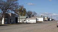 Main Street Hafford | |
 Location of Hafford in Saskatchewan  Hafford (Canada) | |
| Coordinates: 52°50′31″N 107°22′55″W / 52.842°N 107.382°W | |
| Country | Canada |
| Province | Saskatchewan |
| Region | West-central |
| Census division | 16 |
| Rural Municipality | Redberry |
| Incorporated (Village) | 1913 |
| Incorporated (Town) | 1 January 1981 |
| Government | |
| • Mayor | N/A |
| • Town Manager | N/A |
| • Governing body | Hafford Town Council |
| Area | |
| • Total | 0.80 km2 (0.31 sq mi) |
| Population (2011) | |
| • Total | 407 |
| • Density | 496.8/km2 (1,287/sq mi) |
| Time zone | CST |
| Postal code | S0J 1A0 |
| Area code(s) | 306 |
| Highways | Highway |
| Railways | Carlton Trail Railway |
| [2][3][4][5] | |
Hafford is a town in Redberry No. 435, Saskatchewan, Canada consisting of 407 residents at the 2006 Canada Census. It is located near Redberry Lake, which consists of only salt water.
History
The first overseer was T.G. Bavin for the village of Hafford in 1914. The Hafford Village Council and Board of Trade requested a doctor, and Dr. Whitemarsh was appointed for the village. The early community was first served by Luxembourg Post Office. The early village had three lumber yards, a general store, I.H.C. agency, a poolroom, livery barn, hardware, and post office. In 1913 the Canadian Bank of Commerce and the first restaurant opened. The hotel and bar were established in 1914. Power came to Hafford in 1916, and the Hafford Rural Telephone Company was established in 1916. The Hafford hospital was built in 1922. Hafford was served by the Ukrainian Catholic Church established 1911, the Ukrainian Orthodox church built 1909, the Roman Catholic Church erected about the same time. The Anglican church was built in 1918, and the Methodist church which was erected in Hafford moved to Richard.[1]
Demographics
| Canada census – Hafford community profile | |||
|---|---|---|---|
| 2006 | |||
| Population: | 360 (-10.2% from 2001) | ||
| Land area: | 0.80 km2 (0.31 sq mi) | ||
| Population density: | 450.5/km2 (1,167/sq mi) | ||
| Median age: | 55.8 (M: 55.4, F: 57.0) | ||
| Total private dwellings: | 228 | ||
| Median household income: | $Not Available | ||
| References: 2006[6] earlier[7] | |||
Education
The Hafford community was served firstly by the Whiteberry School District which constructed their school building over two years 1906-1908, opening in 1909 followed by the Rus School District opening 1910. In this area, the Alberton School District, Gooseberry School District, Slawa School District and the Craigmore School District were all organised in 1912. The Hafford School District and Nauka School Districts were organised in 1914, Langley School District 1916, and both the Lost Lake School District, and the Canada School District in 1918.[1]
Transportation
Historically, the railroad connecting Prince Albert and North Battleford was laid in 1913, and upon the rail line, a site was chosen for the village of Hafford site.[1] The community is served by Hafford Airport which is located 1 nautical mile (1.9 km) northwest and the Carlton Trail Railway that runs parallel to Highway 40.
Notable people
- Sonia Scurfield, the second woman (and the only Canadian woman) to have her name engraved on the Stanley Cup
- Allen B. Sulatycky, former Associate Chief Justice of the Court of Queen's Bench of Alberta
- Jason Herter, former professional hockey player, played one game with the NHL's New York Islanders
- Vivian Prokop, named for three consecutive years in the WXN Top 100 Most Powerful Women in Canada 2010, 2011, 2012 & recipient of a 2013 Queen Elizabeth ll Diamond Jubilee Medal from Prime Minister Stephen Harper for her contribution to entrepreneurship in Canada which launched 5,000 new businesses creating over 20,000 new jobs as the CEO of The Canadian Youth Business Foundation (CYBF), and for her international work as the Founder of the G20 Young Entrepreneur Alliance (G20YEA).
Notable features
The Dominion Government Illustration Station was operated between 1932-1955. This station tested grains, and fertilizers and improved livestock.[1]
Climate
| Climate data for Hafford | |||||||||||||
|---|---|---|---|---|---|---|---|---|---|---|---|---|---|
| Month | Jan | Feb | Mar | Apr | May | Jun | Jul | Aug | Sep | Oct | Nov | Dec | Year |
| Record high °C (°F) | 9.5 (49.1) |
8.5 (47.3) |
18 (64) |
30.6 (87.1) |
35 (95) |
37.5 (99.5) |
36.5 (97.7) |
37 (99) |
33 (91) |
29.4 (84.9) |
18.9 (66) |
8 (46) |
37.5 (99.5) |
| Average high °C (°F) | −11.9 (10.6) |
−9.3 (15.3) |
−1.4 (29.5) |
9.9 (49.8) |
18.1 (64.6) |
21.9 (71.4) |
23.9 (75) |
23.4 (74.1) |
16.7 (62.1) |
9.9 (49.8) |
−3.3 (26.1) |
−10.8 (12.6) |
7.3 (45.1) |
| Daily mean °C (°F) | −17 (1) |
−14.5 (5.9) |
−6.9 (19.6) |
3.7 (38.7) |
11 (52) |
15.1 (59.2) |
17.2 (63) |
16.2 (61.2) |
10.1 (50.2) |
3.7 (38.7) |
−7.7 (18.1) |
−15.7 (3.7) |
1.3 (34.3) |
| Average low °C (°F) | −22.2 (−8) |
−19.7 (−3.5) |
−12.2 (10) |
−2.5 (27.5) |
3.9 (39) |
8.3 (46.9) |
10.4 (50.7) |
9 (48) |
3.4 (38.1) |
−2.6 (27.3) |
−12.1 (10.2) |
−20.5 (−4.9) |
−4.7 (23.5) |
| Record low °C (°F) | −46.7 (−52.1) |
−42.8 (−45) |
−37.2 (−35) |
−28.3 (−18.9) |
−9.4 (15.1) |
−3.5 (25.7) |
0.6 (33.1) |
−3.5 (25.7) |
−9 (16) |
−24 (−11) |
−36 (−33) |
−43 (−45) |
−46.7 (−52.1) |
| Average precipitation mm (inches) | 13.7 (0.539) |
8.1 (0.319) |
13.2 (0.52) |
23.1 (0.909) |
50.7 (1.996) |
67.5 (2.657) |
79.3 (3.122) |
38.4 (1.512) |
39.2 (1.543) |
14.8 (0.583) |
13.9 (0.547) |
14.2 (0.559) |
375.9 (14.799) |
| Source: Environment Canada[8] | |||||||||||||
See also
Footnotes
- 1 2 3 4 5 Hafford District History Committee (c. 1955), M.W. Holotta, Mrs. M Lommer, P.J. Oschipok, eds., Sketches of Hafford and District, p. 9
- ↑ National Archives, Archivia Net, Post Offices and Postmasters
- ↑ Government of Saskatchewan, MRD Home, Municipal Directory System, archived from the original (– Scholar search) on 21 November 2008
- ↑ Canadian Textiles Institute. (2005), CTI Determine your provincial constituency, archived from the original on 11 September 2007
- ↑ Commissioner of Canada Elections, Chief Electoral Officer of Canada (2005), Elections Canada On-line
- ↑ "2006 Community Profiles". Canada 2006 Census. Statistics Canada. March 30, 2011. Retrieved 2009-02-24.
- ↑ "2001 Community Profiles". Canada 2001 Census. Statistics Canada. February 17, 2012.
- ↑ Environment Canada Canadian Climate Normals 1971–2000, accessed 27 July 2010
External links
| Wikimedia Commons has media related to Hafford, Saskatchewan. |
Places adjacent to Hafford | ||||||||||
|---|---|---|---|---|---|---|---|---|---|---|
| ||||||||||