Glenarden, Maryland
| Glenarden, Maryland | |
|---|---|
| City | |
| Motto(s): "A City On The Move"[1] | |
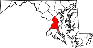
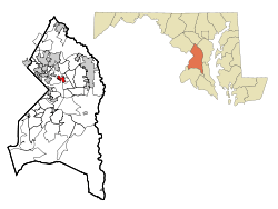 Location of Glenarden, Maryland | |
| Coordinates: 38°55′55″N 76°51′42″W / 38.93194°N 76.86167°WCoordinates: 38°55′55″N 76°51′42″W / 38.93194°N 76.86167°W | |
| Country |
|
| State |
|
| County |
|
| Founded | 1919 |
| Incorporated | March 30, 1939[1] |
| Area[2] | |
| • Total | 1.22 sq mi (3.16 km2) |
| • Land | 1.22 sq mi (3.16 km2) |
| • Water | 0 sq mi (0 km2) |
| Elevation | 102 ft (31 m) |
| Population (2010)[3] | |
| • Total | 6,000 |
| • Estimate (2016)[4] | 6,178 |
| • Density | 4,900/sq mi (1,900/km2) |
| Time zone | UTC-5 (Eastern (EST)) |
| • Summer (DST) | UTC-4 (EDT) |
| ZIP codes | 20706, 20774 |
| Area code(s) | 301 |
| FIPS code | 24-32500 |
| GNIS feature ID | 0597453 |
| Website | City of Glenarden, Maryland |
Glenarden is a city in Prince George's County, Maryland, United States.[5] The population was 6,000 at the 2010 census.
History
The city was developed in 1919 when W. R. Smith purchased a group of properties about 10 miles east Washington, D.C., and established a residential community of 15 people. Three decades later, under the banner of the Civic Association, the African-American, middle-class suburban community that had developed from Smith’s venture petitioned the State Legislature for incorporation as the Town of Glenarden. The charter was granted on March 30, 1939, making Glenarden the third predominately black incorporated town in the State of Maryland. W. H. Swann was elected as its first mayor.[1][6]
Geography
Glenarden is located at 38°55′55″N 76°51′42″W / 38.93194°N 76.86167°W (38.932061, -76.861648).[7]
According to the United States Census Bureau, the city has a total area of 1.22 square miles (3.16 km2), all of it land.[2]
Demographics
| Historical population | |||
|---|---|---|---|
| Census | Pop. | %± | |
| 1950 | 492 | — | |
| 1960 | 1,336 | 171.5% | |
| 1970 | 4,447 | 232.9% | |
| 1980 | 4,993 | 12.3% | |
| 1990 | 5,025 | 0.6% | |
| 2000 | 6,318 | 25.7% | |
| 2010 | 6,000 | −5.0% | |
| Est. 2016 | 6,178 | [4] | 3.0% |
| U.S. Decennial Census[8] | |||
2010 census
As of the census[3] of 2010, there were 6,000 people, 2,077 households, and 1,535 families residing in the city. The population density was 4,918.0 inhabitants per square mile (1,898.9/km2). There were 2,256 housing units at an average density of 1,849.2 per square mile (714.0/km2). The racial makeup of the city was 2.4% White, 92.1% African American, 0.3% Native American, 0.6% Asian, 2.9% from other races, and 1.7% from two or more races. Hispanic or Latino of any race were 6.0% of the population.
There were 2,077 households of which 44.8% had children under the age of 18 living with them, 30.4% were married couples living together, 37.6% had a female householder with no husband present, 6.0% had a male householder with no wife present, and 26.1% were non-families. 23.1% of all households were made up of individuals and 7.2% had someone living alone who was 65 years of age or older. The average household size was 2.89 and the average family size was 3.36.
The median age in the city was 31.5 years. 31.2% of residents were under the age of 18; 10.3% were between the ages of 18 and 24; 25.3% were from 25 to 44; 21.8% were from 45 to 64; and 11.6% were 65 years of age or older. The gender makeup of the city was 43.8% male and 56.2% female.
2000 census
As of the census[9] of 2000, there were 6,318 people, 2,078 households, and 1,664 families residing in the city. The population density was 4,828.9 people per square mile (1,862.1/km²). There were 2,167 housing units at an average density of 1,656.3 per square mile (638.7/km²). The racial makeup of the city was 0.85% White, 95.77% African American, 0.36% Native American, 0.65% Asian, 0.03% Pacific Islander, 0.36% from other races, and 1.96% from two or more races. Hispanic or Latino of any race were 0.76% of the population.
There were 2,078 households out of which 41.5% had children under the age of 18 living with them, 37.9% were married couples living together, 36.7% had a female householder with no husband present, and 19.9% were non-families. 17.7% of all households were made up of individuals and 5.0% had someone living alone who was 65 years of age or older. The average household size was 3.04 and the average family size was 3.39.
In the city, the population was spread out with 35.6% under the age of 18, 7.8% from 18 to 24, 27.0% from 25 to 44, 20.0% from 45 to 64, and 9.6% who were 65 years of age or older. The median age was 31 years. For every 100 females, there were 79.9 males. For every 100 females age 18 and over, there were 68.7 males.
The median income for a household in the city was $44,583, and the median income for a family was $45,932. Males had a median income of $37,961 versus $32,953 for females. The per capita income for the city was $18,578. About 15.9% of families and 15.6% of the population were below the poverty line, including 25.0% of those under age 18 and 7.5% of those age 65 or over.
Government
Prince George's County Police Department District 3 Station in Landover CDP serves the community.[10]
Education
The city is a part of the Prince George's County Public Schools.[11]
The following zoned elementary schools serve portions of the city:[12]
- Ardmore Elementary School
- Dodge Park Elementary School
- Kingsford Elementary School
- William Paca Elementary School
- Judge Sylvania W. Woods, Sr. Elementary School
Glenarden also has Glenarden Woods Elementary School, a non-zoned school.[13]
The following middle schools serve portions of the city: Kenmoor and Ernest Everett Just.[14] The following high schools serve portions of the city: DuVal High School and Charles H. Flowers High School.[15]
Bordering areas
- Springdale (Northeast)
- Palmer Park (Southwest)
- Capitol Heights (Northwest)
- Lanham (Northwest)
References
- 1 2 3 "City of Glenarden, Maryland". City of Glenarden, Maryland. Retrieved August 25, 2012.
- 1 2 "US Gazetteer files 2010". United States Census Bureau. Archived from the original on January 24, 2012. Retrieved 2013-01-25.
- 1 2 "American FactFinder". United States Census Bureau. Retrieved 2013-01-25.
- 1 2 "Population and Housing Unit Estimates". Retrieved June 9, 2017.
- ↑ U.S. Geological Survey Geographic Names Information System: Glenarden, Maryland
- ↑ "Glenarden, Maryland". City-Data.com. Retrieved August 24, 2012.
- ↑ "US Gazetteer files: 2010, 2000, and 1990". United States Census Bureau. 2011-02-12. Retrieved 2011-04-23.
- ↑ "Census of Population and Housing". Census.gov. Archived from the original on May 12, 2015. Retrieved June 4, 2015.
- ↑ "American FactFinder". United States Census Bureau. Archived from the original on 2013-09-11. Retrieved 2008-01-31.
- ↑ "District 3 Station - Landover." Prince George's County Police Department. Retrieved on September 9, 2018. " 7600 Barlowe Road Landover, MD 20785 ". Beat map. See 2010 U.S. Census Map of Landover CDP.
- ↑ "2010 CENSUS - CENSUS BLOCK MAP: Glenarden city, MD." U.S. Census Bureau. Retrieved on September 1, 2018.
- ↑ "NEIGHBORHOOD ELEMENTARY SCHOOLS AND BOUNDARIES SCHOOL YEAR 2018-2019." Prince George's County Public Schools. Retrieved on August 26, 2018.
- ↑ "Glenarden Woods Elementary." Prince George's County Public Schools. Retrieved on September 1, 2018. "7801 Glenarden Parkway Glenarden, MD 20706"
- ↑ "NEIGHBORHOOD MIDDLE SCHOOLS AND BOUNDARIES SCHOOL YEAR 2018-2019." Prince George's County Public Schools. Retrieved on August 26, 2018.
- ↑ "NEIGHBORHOOD HIGH SCHOOLS AND BOUNDARIES SCHOOL YEAR 2018-2019." Prince George's County Public Schools. Retrieved on August 26, 2018.
External links
| Wikimedia Commons has media related to Glenarden, Maryland. |
- The Official Website for the City of Glenarden, Maryland
- The Official Maryland website on Glenarden, Maryland Contains population and housing information from Maryland MSA