Higashishirakawa, Gifu
| Higashishirakawa 東白川村 | |||
|---|---|---|---|
| Village | |||
 Higashishirakawa Village Hall | |||
| |||
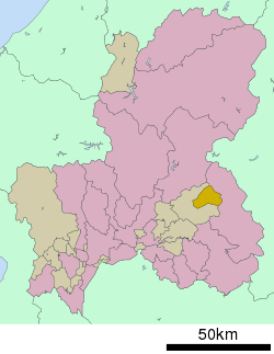 Location of Higashishirakawa in Gifu Prefecture | |||
 Higashishirakawa | |||
| Coordinates: 35°38′33.1″N 137°19′25.8″E / 35.642528°N 137.323833°ECoordinates: 35°38′33.1″N 137°19′25.8″E / 35.642528°N 137.323833°E | |||
| Country | Japan | ||
| Region | Chūbu | ||
| Prefecture | Gifu | ||
| District | Kamo | ||
| Government | |||
| • Mayor | Yasue Shin'ichi[1] | ||
| Area | |||
| • Total | 87.09 km2 (33.63 sq mi) | ||
| Population (November 1, 2017) | |||
| • Total | 2,336 | ||
| • Density | 27/km2 (69/sq mi) | ||
| Time zone | UTC+9 (Japan Standard Time) | ||
| City symbols | |||
| - Tree | Acer pycnanthum | ||
| - Flower | Rhododendron dilatatum | ||
| Phone number | 0574-78-3111 | ||
| Address | Kando 548, Higashishirakawa-mura, Kamo-gun, Gifu-ken 509-1392 | ||
| Website | Official website | ||

Higashishirakawa (東白川村 Higashishirakawa-mura) is a village located in Kamo District, Gifu Prefecture, Japan. As of 31 November 2017, the village had an estimated population of 2,336 and a population density of 27 persons per km2, in 858 households.[2] The total area of the village was 87.09 square kilometres (33.63 sq mi). Higashishirakawa has been selected as one of The Most Beautiful Villages in Japan.[3]
Geography
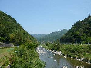
Higashishirakawa is located in the [Mino-Mikawa Plateau of central Gifu Prefecture, surrounded by 1000-meter class mountains. Over 90% of the village area is forested. The town village has a climate characterized by characterized by hot and humid summers, and mild winters (Köppen climate classification Cfa). The average annual temperature in Higashishirakawa is 12.7 °C. The average annual rainfall is 2038 mm with September as the wettest month.The temperatures are highest on average in August, at around 25.4 °C, and lowest in January, at around 0.4 °C.[4]
Neighbouring municipalities
- Gifu Prefecture
Demographics
Per Japanese census data,[5] the population of Higashishirakawa has declined steadily over the past 40 years.
| Census Year | Population |
|---|---|
| 1970 | 4,080 |
| 1980 | 3,578 |
| 1990 | 3,323 |
| 2000 | 2,980 |
| 2010 | 2,513 |
History
The area around Higashishirakawa was part of traditional Mino Province. During the Edo period, it was part of the territory controlled by Naegi Domain. During the post-Meiji restoration cadastral reforms, the area was organised into Kamo District, Gifu Prefecture. The village of Higashishirawa was formed on July 1, 1889 with the establishment of the modern municipalities system. The early Meiji period Haibutsu kishaku movement was especially strong in this area, and to this day, Higashishirakawa is the only municipality in Japan without a single Buddhist temple. Plans to merge the village with the neighbouring city of Gifu were rejected by a referendum in June 2004.
Economy
The mainstay of the local economy is agriculture and forestry.
Education
Higashishirakawa has one public elementary school and one public middle school operated by the village government. The village does not have a high school.
Transportation
Railway
The village does not have any passenger train service.
Highway
References
- ↑ 村長室へようこそ. Higashishirakawa official website (in Japanese). Archived from the original on August 9, 2011. Retrieved August 13, 2011.
- ↑ Official home page
- ↑ The Most Beautiful Villages in Japan (in Japanese)
- ↑ Higashishirakawa climate data
- ↑ Higashishirakawa population statistics
External links
![]()
- Official website (in Japanese)