Kamo District, Gifu
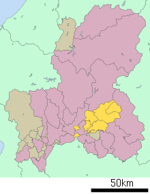
Location of Kamo District in Gifu Prefecture
Kamo (加茂郡 Kamo-gun) is a district located in Gifu Prefecture, Japan. As of July, 2011 the district has an estimated population of 52,536.[1] The total area is 615.17 km².
Towns and villages
District timeline
References
- ↑ 岐阜県の人口・世帯数人口動態統計調査結果. Gifu prefectural website (in Japanese). Gifu Prefecture. Retrieved September 11, 2011.
- 1 2 トップページ(坂祝町のプロフィール) > 町の概要. Sakahogi official website (in Japanese). Archived from the original on August 19, 2011. Retrieved August 12, 2011.
- ↑ 坂祝町の年表 (PDF). Sakahogi official website (in Japanese). Retrieved 25 August 2011.
This article is issued from
Wikipedia.
The text is licensed under Creative Commons - Attribution - Sharealike.
Additional terms may apply for the media files.