Minokamo, Gifu
| Minokamo 美濃加茂市 | |||
|---|---|---|---|
| City | |||
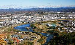 View of Downtown Minokamo, Kiso River and Mount Ontake, from Mount Hatobuki | |||
| |||
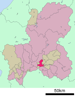 Location of Minokamo in Gifu Prefecture | |||
 Minokamo | |||
| Coordinates: 35°26′24.8″N 137°0′56.4″E / 35.440222°N 137.015667°ECoordinates: 35°26′24.8″N 137°0′56.4″E / 35.440222°N 137.015667°E | |||
| Country | Japan | ||
| Region | Chūbu | ||
| Prefecture | Gifu | ||
| Government | |||
| • Mayor | Naoyoshi Watanabe | ||
| Area | |||
| • Total | 74.81 km2 (28.88 sq mi) | ||
| Population (December 1, 2017) | |||
| • Total | 56,638 | ||
| • Density | 760/km2 (2,000/sq mi) | ||
| Time zone | UTC+9 (Japan Standard Time) | ||
| City symbols | |||
| - Tree | Aphananthe aspera[1] | ||
| - Flower | Hydrangea[1] | ||
| Phone number | 0574-25-2111 | ||
| Address | 3431-1 Ōta-chō, Minokamo-shi, Gifu-ken 505-8606 | ||
| Website | Official website | ||


Minokamo (美濃加茂市 Minokamo-shi) is a city located in Gifu, Japan. As of 30 November 2017, the city had an estimated population of 56,638 and a population density of 74.81 persons per km2, in 22,076 households.[2] The total area of the city was 74.81 square kilometres (28.88 sq mi).
Geography
Minokamo is located in south-central Gifu Prefecture in the Nōbi Plain, between the Hida Mountains and the Kiso River.
Neighbouring municipalities
Demographics
Per Japanese census data,[3] the population of Minokamo has increased rapidly over the past 40 years..
| Census Year | Population |
|---|---|
| 1970 | 35,075 |
| 1980 | 39,531 |
| 1990 | 43,013 |
| 2000 | 50,063 |
| 2010 | 54,729 |
Climate
The city has a climate characterized by hot and humid summers, and mild winters (Köppen climate classification Cfa). The average annual temperature in Minokamo is 15.2 °C. The average annual rainfall is 1982 mm with September as the wettest month. The temperatures are highest on average in August, at around 27.9 °C, and lowest in January, at around 3.5 °C.[4]
| Climate data for Minokamo | |||||||||||||
|---|---|---|---|---|---|---|---|---|---|---|---|---|---|
| Month | Jan | Feb | Mar | Apr | May | Jun | Jul | Aug | Sep | Oct | Nov | Dec | Year |
| Record high °C (°F) | 16.6 (61.9) |
20.3 (68.5) |
24.7 (76.5) |
30.2 (86.4) |
33.6 (92.5) |
36.1 (97) |
37.9 (100.2) |
39.5 (103.1) |
38.4 (101.1) |
32.6 (90.7) |
25.1 (77.2) |
21.9 (71.4) |
39.5 (103.1) |
| Average high °C (°F) | 8.0 (46.4) |
9.2 (48.6) |
13.1 (55.6) |
19.5 (67.1) |
24.1 (75.4) |
27.3 (81.1) |
30.9 (87.6) |
32.7 (90.9) |
28.4 (83.1) |
22.5 (72.5) |
16.4 (61.5) |
10.8 (51.4) |
20.2 (68.4) |
| Average low °C (°F) | −1.8 (28.8) |
−1.4 (29.5) |
1.8 (35.2) |
7.4 (45.3) |
12.6 (54.7) |
17.8 (64) |
21.9 (71.4) |
22.9 (73.2) |
19.1 (66.4) |
12.0 (53.6) |
5.6 (42.1) |
0.3 (32.5) |
9.9 (49.7) |
| Record low °C (°F) | −8.7 (16.3) |
−8.6 (16.5) |
−8.9 (16) |
−2.0 (28.4) |
1.9 (35.4) |
8.3 (46.9) |
15.2 (59.4) |
15.3 (59.5) |
7.8 (46) |
0.9 (33.6) |
−2.5 (27.5) |
−6.9 (19.6) |
−8.9 (16) |
| Average precipitation mm (inches) | 57.8 (2.276) |
72.7 (2.862) |
137.1 (5.398) |
148.9 (5.862) |
187.2 (7.37) |
230.0 (9.055) |
270.3 (10.642) |
156.6 (6.165) |
231.3 (9.106) |
126.2 (4.969) |
92.9 (3.657) |
52.3 (2.059) |
1,763.3 (69.421) |
| Average precipitation days (≥ 1.0 mm) | 8.0 | 7.7 | 10.1 | 10.6 | 11.3 | 12.7 | 13.7 | 9.2 | 11.8 | 9.2 | 8.2 | 7.7 | 120.2 |
| Mean monthly sunshine hours | 142.9 | 157.3 | 187.7 | 192.8 | 184.1 | 143.0 | 158.0 | 198.9 | 156.0 | 157.5 | 142.3 | 145.8 | 1,966.3 |
| Source: Japan Meteorological Agency | |||||||||||||
History
The area around Minokamo was part of traditional Mino Province. In the Edo period, the area was divided between the holdings of Owari Domain and Naegi Domain, and tenryō holdings directly under the Tokugawa shogunate. Ōta-juku florished as a post station on the Nakasendō highway connecting Edo with Kyoto]. In the post-Meiji restoration cadastral reforms, Kamo District in Gifu prefecture was created. The modern city was formed on April 1, 1954 by the merger of the towns of Ota and Furui with the villages of Yamanoue, Hachiya, Kamono, Ibuka, Shimoyoneda and Miwa.[5]
Government
Minokamo has a mayor-council form of government with a directly elected mayor and a unicameral city legislature of 16 members.
Economy
The area around Minokamo was formerly known for sericulture. Agriculture, including horticulture remains an important component of the local economy. However, since the 1960s, the area has become increasingly industrialized as part of the Chubu Plateau Industrial Zone. Industries include textiles, semiconductor, electronics, machine tools and automotive components.
Education
Colleges and universities
- Shogen Junior College
- Colégio Isaac Newton Japão ("Isaac Newton College Japan"; イザキ・ニュートン・カレッジ) - Brazilian school[6]
Primary and secondary schools
Minokamo has nine public elementary schools and two public middle schools and one combined middle/high school operated by the city government. The city has two public high schools operated by the Gifu Prefectural Board of Education, and the prefecture also operates one special education school..
Transportation
Railway
- Central Japan Railway Company (JR Central) - Takayama Main Line
- Central Japan Railway Company (JR Central) - Taita Line
Highway
Sister city relations
Local attractions
- Shōgen-ji, a Buddhist monastery
Notable people from Minokamo
- Tsubouchi Shōyō, author
References
- 1 2 市の紹介. Minokamo official website (in Japanese). Retrieved 11 August 2011.
- ↑ Official home page
- ↑ Minokamo population statistics
- ↑ Minokamo climate data
- ↑ 生活情報 > Q&A: 美濃加茂市の面積が知りたい. Minokamo official website (in Japanese). Retrieved 25 August 2011.
- ↑ "Escolas Brasileiras Homologadas no Japão" (Archive). Embassy of Brazil in Tokyo. Retrieved on October 13, 2015.
External links

- Minokamo City official website (in Japanese)
- Minokamo City official website