Mino, Gifu
| Mino 美濃市 | |||
|---|---|---|---|
| City | |||
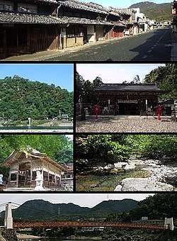 Mino-machi Nagara River, Hachiman Shrine Oyada Jinja, Katawa Gorge Mino Bridge | |||
| |||
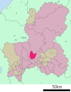 Location of Mino in Gifu Prefecture | |||
 Mino | |||
| Coordinates: 35°32′41.1″N 136°54′27.2″E / 35.544750°N 136.907556°ECoordinates: 35°32′41.1″N 136°54′27.2″E / 35.544750°N 136.907556°E | |||
| Country | Japan | ||
| Region | Chūbu | ||
| Prefecture | Gifu | ||
| Government | |||
| • Mayor | Tetsuhiro Muto[1] | ||
| Area | |||
| • Total | 117.01 km2 (45.18 sq mi) | ||
| Population (November 30, 2017) | |||
| • Total | 21,101 | ||
| • Density | 180/km2 (470/sq mi) | ||
| Time zone | UTC+9 (Japan Standard Time) | ||
| City symbols | |||
| - Tree | Maple | ||
| - Flower | Ume | ||
| Phone number | 0575-33-1122 | ||
| Address | 1350 Mino-shi, Gifu-ken 501-3792 | ||
| Website | Official website | ||


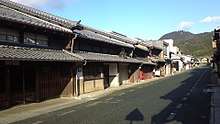
Mino (美濃市 Mino-shi) is a city located in Gifu, Japan. As of 30 November 2017, the city had an estimated population of 21,101, and a population density of 180 persons per km2, in 8140 households.[2] The total area of the city was 117.01 square kilometres (45.18 sq mi). The city is renowned for traditional Japanese Mino washi paper and its streets, which are in the style of the early Edo period (1603-1868). An urban area known as "Udatsu Townscape" (うだつのあがるまちなみ) is designated as an important traditional building group conservation area by the government on May 13, 1999.
Geography
Mino is located in the south-central Gifu Prefecture. The Nagara River and the Itadori River flow through the city. Mino is surrounded by the city of Seki to the west, south and east, and by the city of Gujō to the north.
Climate
The city has a climate characterized by characterized by hot and humid summers, and mild winters (Köppen climate classification Cfa). The average annual temperature in Mino is 15.0 °C. The average annual rainfall is 2172 mm with September as the wettest month. The temperatures are highest on average in August, at around 27.8 °C, and lowest in January, at around 3.2 °C.[3]
Neighbouring municipalities
Demographics
Per Japanese census data,[4] the population of Mino has decreased gradually over the past 40 years..
| Census Year | Population |
|---|---|
| 1970 | 26,421 |
| 1980 | 26,825 |
| 1990 | 26,022 |
| 2000 | 24,662 |
| 2010 | 22,629 |
History
The area around Mino was part of traditional Mino Province. During the Edo period, Kanamori Nagachika, the founder of Takayama Domain was granted permission by Tokugawa Ieyasu to build Oguriyama Castle on the Nagara River. Due to floods, the castle town was relocated in 1605 to higher ground. The area later became part of the holdings of Owari Domain under the Tokugawa shogunate. In the post-Meiji restoration cadastral reforms, Mugi District in Gifu prefecture was created, and with the establishment of the modern municipalities system on July 1, 1889 the town of Kozuchi was created. In July 1909 Mino was the site of a meteorite impact. The meteorite, which massed about 13.5 kg, broke into pieces and fell across an area 13 miles long and 5 miles wide. The largest piece, an bout 4 kg, fell in the village of Gokurakuji.[5] On April 1, 1911, it was renamed Mino Town. Mino was raised to city status on April 1, 1954 with the merger of the town of Mino with the villages of Suhara, Shimomaki, Kamimaki, Oyada, Aimi, and Nakauchi.
Government
Mino has a mayor-council form of government with a directly elected mayor and a unicameral city legislature of 13 members.
Education
Mino has five public elementary schools and two public middle schools operated by the city government. The city has one public high school operated by the Gifu Prefectural Board of Education.
Transportation
Railway
Highway
Sister city relations
Local attractions
- Ogurayama Castle Ruins
- Yawata Shrine
Notable people from Mino
- Chiune Sugihara, diplomat
References
- ↑ 美濃市について. Mino official webpage (in Japanese). Retrieved 10 December 2017.
- ↑ Official home page
- ↑ Mino climate data
- ↑ Mino population statistics
- ↑ Mino meteorite at gifu-u.ac.jp (Japanese)
External links

- Mino City official website (in Japanese)