Galinhas Island
| Ilha das Galinhas | |
|---|---|
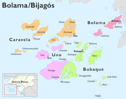 Map of the sectors of the Bolama Region | |
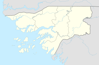 Galinhas Island Location within Guinea-Bissau | |
| Geography | |
| Location | Atlantic Ocean |
| Coordinates | 11°28′00″N 15°41′00″W / 11.4667°N 15.6833°WCoordinates: 11°28′00″N 15°41′00″W / 11.4667°N 15.6833°W |
| Archipelago | Bissagos Islands |
| Area | 50 km2 (19 sq mi) |
| Length | 10 km (6 mi) |
| Width | 6 km (3.7 mi) |
| Administration | |
| Region | Bolama Region |
| Demographics | |
| Population | 1500 (2001) |
| Pop. density | 30 /km2 (80 /sq mi) |
Galinhas Island (Portuguese: Ilha das Galinhas)[1]is an island in the Bijagós Archipelago of Guinea-Bissau.
Geography
Galinhas Island is located 60 km southwest of Bolama town. The Canal de Bolama separates it from Bolama Island, the easternmost island of the group that lies close to the mainland. The area of the island is 50 km², its length is 10 km and its width is 6 km.[2]
Galinhas Island is home to over 1,500 people. Settlements include Ambancana (Ambankana), Acampamento, Ametite and others includes Ancano (Ankano) and Anchorupe (Anshorup). Chief production are cashew nuts which are mainly exported to India. Landmarks on the island include the former Portuguese prison and governor's house. Some boats from Bissau to Bubaque call at the island. Nearby islands and islets includes Formosa to the west and Roxa to the south.
The islet also has its own lighthouse, its class of light is Fl (3) W 15s. and has a focla height of 7 metres. Its range is 16-17 km (9 nautical miles).
References
- ↑ "Ilha das Galinhas". Mapcarta. Retrieved 14 October 2016.
- ↑ GoogleEarth
Bolama (capital) | ||
| Sectors | ||
| Islands |
| |
| Parks | ||