Roxa
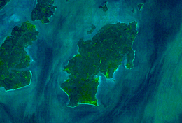 Satellite view | |
 | |
 Roxa (Canhabaque) | |
| Geography | |
|---|---|
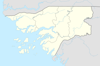
| Location | Atlantic Ocean |
| Archipelago | Bissagos Islands |
| Area | 111 km2 (43 sq mi) |
| Length | 20 km (12 mi) |
| Width | 11 km (6.8 mi) |
| Administration | |
|
Guinea-Bissau | |
| Demographics | |
| Population | c. 3 500 |
Roxa or Canhabaque is an island in the Bissagos Islands, Guinea-Bissau. Its area is 111 square kilometres (43 sq mi) and is 20 kilometres (12 mi) long and 11 kilometres (6.8 mi) wide. Almost the entire island is made up of mangrove forests.[1] Anagaru (Anagaro), Anchurupi, Bana, Egubane and Porcos are its surrounding islets located nearly 2 kilometres (1.2 mi) north.[2] Its current population is around 3,000 to 4,000 and may have reached 5,000. Each village consists of a unity of social independence.
About the island
The island consists of 19 smaller villages and are: Anchurupi, Ambeno, Ambiur (Ambiour), Ambuduku (Amboudouco), Ancanho (Ankanio), Angojigen (Angogiguem), Angora, Angumba, Ankagium, Ankatip (Ancatipe), Bane, Bini, Ijoni, Indena, Inorei, Inhoda, Meneque (Meneke) and Nulon. Inorei is the chief village of the island and has its main port.
The islet also has its own lighthouse; its class of light is Fl (3) W 15s. and has a focal height of 24 metres (79 ft). Its range is 9 nautical miles (17 km; 10 mi).
References
- ↑ Nóbrega, Álvaro (2009). A gestão do espaço e da propriedade tradicional no arquipélago dos Bijagós (in Portuguese). Instituto Superior em Ciências Sociais e Políticas (High Institute of Social Sciences and Politics.
- ↑ Henry, Christine. Les îles où dansent les enfants défunts: âge, sexe et pouvoir chez les Bijogo de Guinée-Bissau (in French). Paris: MSH. ISBN 2735105857.
Bolama (capital) | ||
| Sectors | ||
| Islands |
| |
| Parks | ||
Coordinates: 11°14′40″N 15°43′25″W / 11.24441°N 15.72349°W