Orango
| Native name: Orango | |
|---|---|
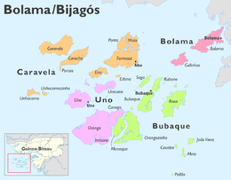 Orango in the Uno Sector | |
| Geography | |
| Location | Atlantic Ocean |
| Coordinates | 11°14′58″N 16°13′16″W / 11.24944°N 16.22111°W |
| Archipelago | Bijagós Archipelago |
| Area | 122.7 km2 (47.4 sq mi) |
| Length | 22.5 km (13.98 mi) |
| Width | 22.5 km (13.98 mi) |
| Administration | |
|
Guinea-Bissau | |
| Region | Bolama |
Orango is one of the Bijagós Islands, located 60 kilometers[1] (38 miles) off the coast of mainland Guinea-Bissau, it is the third largest in the archipelago (after Formosa (or Abu) and Caravela) being 122.7 km², its length and width is 22.5 km. It is the centre of the Ilhas de Orango National Park and has one town, Eticoga. The island is separated by Rio Anabaca (Anabaka) 400 meters long with Canongo and Meneque, in the south, a seaprate meandering 75 meters long separates the smaller island of Imbane from Orango. Nearby islands includes Orangozinho in the east, Uno in the northwest and Uracane in the north.
It belongs to the Uno Sector, until 2004 it was part of the Bubaque Sector.
Orango is known for its saltwater hippopotamuses.[2] It was the seat of Okinka Pampa until her death in 1930.[3]
Matrimonial traditions
Orango's inhabitants developed a number of distinct matrimonial traditions which are unique with respect to the role played by women.[4] Marriage is formally proposed by women — their choice of spouse is made public to the groom-to-be and the rest of the community by an offer of a dish of specially prepared fish, marinated in red palm oil.[1] According to tradition, the offer is accepted by eating the fish, and cannot be turned down without dishonor. The marriage becomes official months later, after the bride-to-be, with no help from the groom, builds the couple a new home out of driftwood, blond grass, and mud bricks.[1]
In recent years the island's traditions are competing with outside influences, both economic and religious. Men increasingly travel to the mainland to work, bringing back the mainland's trappings and ideas. Men and women have adopted religious practices introduced by Protestant missionaries, which have also reduced the influences of the island's matrimonial traditions.
References and footnotes
- 1 2 3 Women, not men, choose spouses on African isle - International Herald Tribune
- ↑ Orango Islands National Park
- ↑ Peter Karibe Mendy; Lobban Jr. (17 October 2013). Historical Dictionary of the Republic of Guinea-Bissau. Scarecrow Press. ISBN 978-0-8108-8027-6.
- ↑ According to anthropologist Christine Henry, a researcher at France's CNRS.
External links
- Blog with pictures (2009) (in Portuguese)
Coordinates: 11°14.965′N 16°13.27′W / 11.249417°N 16.22117°W
Bolama (capital) | ||
| Sectors | ||
| Islands |
| |
| Parks | ||