Güzelyurt
| Güzelyurt | |
|---|---|
| District | |
 | |
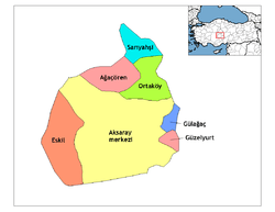 Location of Güzelyurt within Turkey. | |
| Coordinates: 38°17′N 34°22′E / 38.283°N 34.367°E | |
| Country |
|
| Region | Central Anatolia |
| Province | Aksaray |
| Government | |
| • Governor | Ramazan Yıldırım |
| • Mayor | Kudret Özeş (AKP) |
| Area[1] | |
| • District | 322.25 km2 (124.42 sq mi) |
| Elevation | 1,485 m (4,872 ft) |
| Population (2012)[2] | |
| • Urban | 2,672 |
| • District | 12,527 |
| • District density | 39/km2 (100/sq mi) |
| Time zone | UTC+2 (EET) |
| • Summer (DST) | UTC+3 (EEST) |
| Postal code | 68xxx |
| Area code(s) | 0382 |
| Licence plate | 68 |
| Website | www.guzelyurt.gov.tr |
Güzelyurt, formerly Gelveri, is a town and district of Aksaray Province in the Central Anatolia region of Turkey, at a distance of 45 km (28 mi) from the city of Aksaray. According to 2000 census, population of the district is 16,836 of which 3,775 live in the town of Güzelyurt.[3][4] The district covers an area of 322 km2 (124 sq mi),[5] and the average elevation is 1,485 m (4,872 ft).
This area is part of the ancient region of Cappadocia, near the Ihlara Valley.
History
Cappadocia has an important place in the history of Christianity and Gregory of Nazianzus lived in the area. A historically large Greek population existed in the area until the 1924 population exchange (see Cappadocian Greeks), when they were replaced with the Turks from Thessaloniki and Kavala.
Places of interest
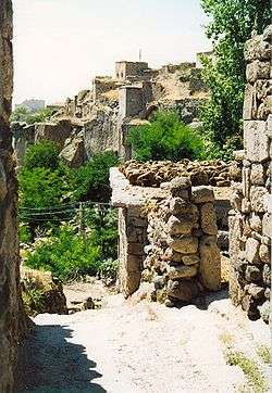
Güzelyurt is known for having three underground cities and over 50 churches carved into the rocky volcanic landscape including:
- Ihlara Valley
- Monastery Valley, "Manastır Vadisi"
- Fairy Chimneys, "Peri Bacaları"
- Antique Greek houses
- Ahmatlı Church
- St. Anargiros Church, "Sivişli Kilise"
- Koç Church
- Cathedral of Selime
- The rock monastery of Selime, one of the largest religious buildings in Cappadocia.
- Red Church, "Kızıl Kilise" - a 5th or 6th century church in the village of Sivrihisar
- Analipsis Church, "Yüksek Kilise" (High Church) on the hill of Analipsis. Stone age relics have been found nearby.
- St. Gregorius Church, "Kilise Cami" - another rock-hewn church, in use today as a mosque
- St. Spyridon Church, "Kızıl Kilise" - another red church in the vicinity of Güzelyurt.
Other places of interest include:
- The tomb of Selime Sultan in the village of Selime.
- Linseed House, "Bezirhane" in the village of Belisırma.
- Ziga thermal springs, "Ziga kaplıcaları" is located in the village of Yaprakhisar very close to Ihlara Valley.
- An underground city is situated in Gaziemir village of Güzelyurt.[6]
Image gallery
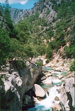
Ihlara Valley 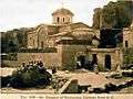
St. Gregorius Church 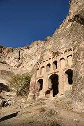
A church in Ihlara Valley
See also
Notes
- ↑ "Area of regions (including lakes), km²". Regional Statistics Database. Turkish Statistical Institute. 2002. Retrieved 2013-03-05.
- ↑ "Population of province/district centers and towns/villages by districts - 2012". Address Based Population Registration System (ABPRS) Database. Turkish Statistical Institute. Retrieved 2013-02-27.
- ↑ Turkish Statistical Institute. "Census 2000, Key statistics for urban areas of Turkey" (XLS) (in Turkish). Retrieved 2008-04-02.
- ↑ GeoHive. "Statistical information on Turkey's administrative units". Retrieved 2008-04-02.
- ↑ Statoids. "Statistical information on districts of Turkey". Retrieved 2008-04-21.
- ↑ Governorship of Aksaray, Turkey. "Underground cities in Aksaray". Archived from the original on March 7, 2008. Retrieved 2008-04-02.
References
- Falling Rain Genomics, Inc. "Geographical information on Güzelyurt, Turkey". Retrieved 2008-04-02.
- Turkish Ministry of Culture and Tourism. "General information on Güzelyurt, Aksaray" (in Turkish). Archived from the original on January 14, 2016. Retrieved 2008-04-02.
- Governorship of Güzelyurt, Aksaray. "Touristic areas in Güzelyurt". Archived from the original on June 19, 2008. Retrieved 2008-04-02.
External links
| Wikimedia Commons has media related to Güzelyurt. |
- District governor's official website (in Turkish) / (in English)
- District municipality's official website (in Turkish)
- Aksaray governor's office (in Turkish) / (in English) / (in French)
- touristic map of Güzelyurt district
| Province: | ||
|---|---|---|
| District: | ||
| Towns: | ||
Coordinates: 38°16′38″N 34°22′19″E / 38.27722°N 34.37194°E
| Authority control |
|---|