Sarıyahşi
| Sarıyahşi | |
|---|---|
| District | |
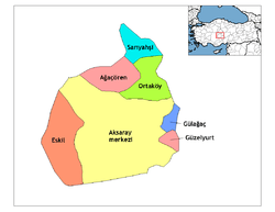 Location of Sarıyahşi within Turkey. | |
 Sarıyahşi Location of Sarıyahşi within Turkey. | |
| Coordinates: 38°59′N 33°51′E / 38.983°N 33.850°E | |
| Country |
|
| Region | Central Anatolia |
| Province | Aksaray |
| Government | |
| • Governor | İskender Çolak |
| • Mayor | Fatih Ünsal (MHP) |
| Area[1] | |
| • District | 279.57 km2 (107.94 sq mi) |
| Elevation | 870 m (2,850 ft) |
| Population (2012)[2] | |
| • Urban | 3,866 |
| • District | 5,481 |
| • District density | 20/km2 (51/sq mi) |
| Time zone | UTC+2 (EET) |
| • Summer (DST) | UTC+3 (EEST) |
| Postal code | 68xxx |
| Area code(s) | 0382 |
| Licence plate | 68 |
| Website | www.sariyahsi.gov.tr |
Sarıyahşi is a town and district of Aksaray Province in the Central Anatolia region of Turkey, at a distance of 110 km (68 mi) from the province seat of Aksaray. According to 2000 census, population of the district is 12,120 of which 7,751 live in the town of Sarıyahşi, and the remainder in surrounding villages.[3] The district covers an area of 280 km2 (108 sq mi),[4] and lies at an average elevation of 870 m (2,854 ft).
The district is good agricultural land watered by Hirfanlı Dam reservoir, and used for growing grain and other crops. There is an uranium mine in the village of Bekdik and various stone quarries.
The town of Sarıyahşi is a small rural centre providing schools and other basic amenities to the surrounding countryside.
Notes
- ↑ "Area of regions (including lakes), km²". Regional Statistics Database. Turkish Statistical Institute. 2002. Retrieved 2013-03-05.
- ↑ "Population of province/district centers and towns/villages by districts - 2012". Address Based Population Registration System (ABPRS) Database. Turkish Statistical Institute. Retrieved 2013-02-27.
- ↑ Turkish Statistical Institute. "Census 2000, Key statistics for urban areas of Turkey" (in Turkish). Archived from the original (XLS) on 2007-07-22. Retrieved 2008-04-03.
- ↑ Statoids. "Statistical information on districts of Turkey". Archived from the original on 2010-05-26. Retrieved 2008-04-22.
References
- Falling Rain Genomics, Inc. "Geographical information on Sarıyahşi, Turkey". Archived from the original on 2012-10-25. Retrieved 2008-04-03.
- Governorship of Sarıyahşi, Turkey. "General information on Sarıyahşi, Aksaray" (in Turkish). Archived from the original on 2008-03-11. Retrieved 2008-04-03.
External links
- Galary website (in Turkish)
- District governor's official website (in Turkish)
- District municipality's official website (in Turkish)
- Local news website (in Turkish)
- Local news website (in German)
| Province: | ||
|---|---|---|
| District: | ||
| Towns: |
| |
Coordinates: 38°59′N 33°51′E / 38.983°N 33.850°E