Freehold tram stop
| Freehold | |
|---|---|
| Metrolink | |
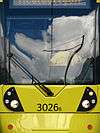
.JPG) An M5000 arrives at Freehold tram stop, in November 2012 | |
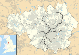 Freehold Location of Freehold in Greater Manchester | |
| Location | |
| Place | Chadderton |
| Local authority | Oldham |
| Coordinates | 53°32′16″N 2°08′16″W / 53.5378°N 2.1379°WCoordinates: 53°32′16″N 2°08′16″W / 53.5378°N 2.1379°W |
| Platforms | 2 |
| Fare zone information | |
| Metrolink Zone | K |
| Present status | In operation |
| Operations | |
| Original operator | Metrolink |
| History | |
| Opened | 13 June 2012[1] |
|
| |
Freehold is a tram stop on the Oldham and Rochdale Line (ORL) of Greater Manchester's light-rail Metrolink system. It opened to passengers on 13 June 2012 as part of Phase 3a of the system's expansion,[1] and is located on Block Lane in Chadderton at its boundary with Oldham in the Metropolitan Borough of Oldham, England.[2][3]
Freehold Metrolink station serves the Cowhill and Block Lane areas of Chadderton and the adjacent Freehold area of Werneth, Oldham from which the station takes its name. The names Cowhill and Block Lane were also considered as names for the station prior to opening, the local council finally opting for the name Freehold. The station is one of the newly built stops on what was the Oldham Loop Line.
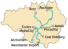
Services
Services run mostly every 6 minutes on all routes.
| Preceding station | Following station | |||
|---|---|---|---|---|
towards East Didsbury | East Didsbury – Rochdale Town Centre Line | towards Rochdale Town Centre |
Connecting bus routes
Freehold station is served by service 159 which stops outside the station on Block Lane. The 159 is operated by Manchester Community Transport and heads northbound to Chadderton town centre, continuing to Oldham, and runs southbound to Hollinwood, continuing to Middleton via Woodhouses, Failsworth and New Moston.
On nearby Denton Lane, Cowhill, First Greater Manchester service 415 provides a direct link to Middleton and Oldham, while the 419, operated by Manchester Community Transport also provides a link to Chadderton and Middleton plus to Ashton-under-Lyne via Hathershaw.[4]
References
- 1 2 "Metrolink line to Oldham set to open". Transport for Greater Manchester. Retrieved 8 June 2012.
- ↑ "the online repository of historic maps - maps page". Old-Maps. Retrieved 2013-06-29.
- ↑ "Freehold Local Area Map". Metrolink. Retrieved 28 January 2018.
- ↑ "Transport for Greater Manchester - Journey Planning - Network Maps". Transport for Greater Manchester. Archived from the original on 2 November 2012. Retrieved 10 September 2012.
External links
| Wikimedia Commons has media related to Freehold tram stop. |
| Tram stops |
|   | ||||||||||||||||||
|---|---|---|---|---|---|---|---|---|---|---|---|---|---|---|---|---|---|---|---|---|
| Operations |
| |||||||||||||||||||
| History (Timeline) |
| |||||||||||||||||||
| Proposed developments |
| |||||||||||||||||||