Forth and Clyde Canal Pathway
| Forth and Clyde Canal Pathway | |
|---|---|
 Along the canal pathway | |
| Length | 106 km (66 mi) |
| Location | Scotland |
| Designation | Scotland's Great Trails |
| Trailheads |
Bowling, west of Glasgow55°55′48″N 4°28′48″W / 55.930°N 4.480°W |
| Use | Hiking, cycling |
| Elevation | |
| Elevation gain/loss | 158 metres (518 ft) gain[1] |
| Hiking details | |
| Website | https://www.scottishcanals.co.uk/activities/walking-running/forth-clyde-and-union-canals/ |
The Forth and Clyde canal pathway runs between the Firth of Forth and the Firth of Clyde and is a 106-kilometre (66 mi) long footpath and cycleway that runs across Scotland, between Bowling, west of Glasgow, and Lochrin Basin (Edinburgh Quay) in Edinburgh. The path runs on the towpaths of the Forth & Clyde and Union Canals and is entirely off road.[2] The path is well maintained and its surface is generally good, although there are some stretches particularly between Falkirk and the outskirts of Edinburgh where wet weather leads to muddy conditions unsuitable for road intended bicycles. It is well used by walkers and cyclists, and designated as one of Scotland's Great Trails by Scottish Natural Heritage.[1] It also forms part of the National Cycle Network, being designated as Route 754.[2] Sustrans advises that the path is best followed from the Clyde to the Forth because the prevailing wind is from the south west.[2] Much of the path is also suitable for experienced horseriders, although in some places low bridges, narrow aqueducts and gates may restrict access for horses.[3]
Route of the path
.jpg)
Following the path west to east, it begins at Bowling Basin where the Forth & Clyde Canal enters the Firth of Clyde. The canal runs east through Clydebank, Boghouse Locks, Clobberhill Locks, Temple Locks and Maryhill Locks. It passes close to the former Singer Sewing Machine Works which once employed 19,000 people and exported sewing machines all over the world, including many to pre-Revolutionary Russia. At Stockingfield Junction near Maryhill is the 'Glasgow Branch' a spur which originally connected to the Monkland Canal (which connected with Port Dundas, close to the city centre of Glasgow).[4]
From Stockingfield Junction the canal path runs north east, through Bishopbriggs, Kirkintilloch and Kilsyth, to the Falkirk Wheel where the Forth & Clyde Canal joins with the Union Canal. A branch of the Forth & Clyde Canal runs from Falkirk to the River Carron, near Grangemouth.[5][6]
The path continues along the towpath of the Union Canal, through Linlithgow, past the red shale bings which are all that remains of Scotland's oilshale industry, and through the outskirts of Edinburgh.[7] Unlike the Forth and Clyde Canal with its many lock systems, the Union Canal is a contour canal and there is only one lock, located near the Falkirk Wheel.
The path ends at the canal port at Lochrin Basin, Edinburgh Quay, near Tollcross, in the centre of Edinburgh.[8] If desired the pathway can be extended a further 3 km through the centre of Edinburgh and down to Leith and Leith Docks.
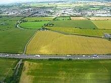
Railway lines run close to the path for most of its length. Bowling Station, on the line from Glasgow, is close to the start of the path.[4] Both Glasgow main line railway stations are in the centre of the city, only a few hundred metres apart. The line which has run close to the path from Bowling to Glasgow passes through Glasgow Central Station low-level. The railway line which runs close to the rest of the path runs from Glasgow Queen Street Station to Edinburgh Haymarket Station. In Croy, Falkirk and Linlithgow the canal passes only a few hundred metres from the railway stations. Edinburgh's Waverley Station and Haymarket Station are only a short distance from Lochrin Basin.[8]
The path can be completed in three, roughly equal, sections:
- Bowling Basin (Bowling Station) to Auchinstarry Basin, Kilsyth (Croy Station)
- Auchinstarry Basin to Linlithgow Canal Centre (Linlithgow Station)
- Linlithgow Canal Centre to Lochrin Basin (Haymarket and Waverley Stations)
Places of interest along the path
- The Slateford Aqueduct on the outskirts of Edinburgh takes the canal over the Water of Leith.[9]
- The Avon Aqueduct is west of Linlithgow and is 250 metres (810 ft) long and 26 metres (86 ft) high. It is the second largest aqueduct in Britain.[10]
- At Broxburn on the Union Canal the path runs between a number of red shale bings. The world's oil industry was started near here by James 'Paraffin' Young who build an industry to extract oil from shale. The bings are the remains of an industry which once employed 10,000 people in the area. Some of the bings have been removed to provide foundation material for motorways, but many remain.
- The Almond Aqueduct is west of Ratho and takes the canal 23 metres (75 ft) above the River Almond.
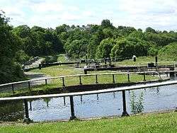
- The Falkirk Wheel allows water craft to move between the Forth & Clyde and Union canals. It replaces the eleven locks that used to allow boats to traverse the 110 feet (34 m) height difference between the two canals.[11]
- The Falkirk Tunnel is the oldest and longest canal tunnel in Scotland. It is 631 metres long, 5.5 metres wide and 6 metres high.
- The burgh of Kilsyth, with Colzium estate and park
- The Antonine Wall, which is an ancient Roman fortification and wall, seen for example at Bar Hill near Twechar
- The Kelvin Aqueduct in Glasgow is 120 metres (400 ft) long and 21 metres (70 ft) high.[12]
Alternative coast to coast routes
Sustrans have devised an alternative coast to coast route across the Central Belt, Route 75. This starts at Gourock on the Firth of Clyde and then goes to Bell's Bridge in Glasgow, via Paisley. It then goes to Edinburgh via Airdrie, the Bathgate Railway Path, the Water of Leith Walkway and the Union Canal towpath.[13] This route is longer at 171 miles (275 km) and only 98 miles (158 km) of the path are off road. Another alternative route across central Scotland is the John Muir Way, which runs from Dunbar to Helensburgh, a distance of 215 kilometres (134 mi). This path includes a section along the Forth and Clyde Canal, and is also designated as one of Scotland's Great Trails.[14]
Gallery
 Auchinstarry Basin
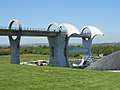 Falkirk Wheel
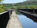 Avon Aqueduct
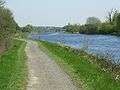 Union Canal
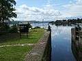 Bowling Basin
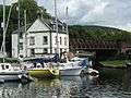 Bowling Basin
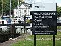 Bowling Basin
 Forth & Clyde signpost
 Union Canal
 Forth & Clyde Lock 27
 Forth & Clyde
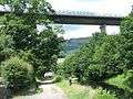 Under the Erskine Bridge
References
- 1 2 "Trails". Scotland's Great Trails. Retrieved 2018-08-30.
- 1 2 3 "Clydebank to Edinburgh (Route 754)". Sustrans. Retrieved 2018-08-30.
- ↑ "Forth, Clyde and Union Canals: Notes on multi-use access – commissioned by Scottish Natural Heritage)" (PDF). Scottish Canals. June 2016. Retrieved 2018-08-30.
- 1 2 "Forth and Clyde Canal: Bowling to Stockingfield Jcn". WalkHighlands. Retrieved 2018-08-31.
- ↑ "Forth and Clyde Canal: Stockingfield Jcn to Kilsyth". WalkHighlands. Retrieved 2018-08-31.
- ↑ "Forth and Clyde Canal: Kilsyth to Falkirk". WalkHighlands. Retrieved 2018-08-31.
- ↑ "Union canal: Linlithgow to Ratho". WalkHighlands. Retrieved 2018-08-31.
- 1 2 "Union Canal: Ratho to Lochrin Basin". WalkHighlands. Retrieved 2018-08-31.
- ↑ Historic Environment Scotland. "Edinburgh, Union Canal, Slateford Aqueduct (52727)". Canmore.
- ↑ Historic Environment Scotland. "Union Canal, Avon Aqueduct (47842)". Canmore.
- ↑ "About the Falkier Wheel". Scottish Canals. Retrieved 2018-08-31.
- ↑ Historic Environment Scotland. "Glasgow, Maryhill, Forth And Clyde Canal, Kelvin Aqueduct (44154)". Canmore.
- ↑ "Route 75". Sustrans. Retrieved 2018-08-30.
- ↑ "John Muir Way". Scotland's Great Trails. Retrieved 2018-08-30.
Maps and guides
- Forth and Clyde and Union Canal - guide & maps to the route on Walkhighlands
- Annotated map of the route
- Forth & Clyde and Union Canals map by GEOprojects [UK]. ISBN 0-86351-139-2.
- Exploring the Edinburgh to Glasgow Canals by Hamish Brown. Mercat Press. Jul 2006. ISBN 1-84183-096-8.