National Cycle Route 65
| NCN Route 65 | |
|---|---|
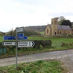 National Cycle Network signpost at the southern end of Route 71 where it meets Route 65 in Kirby Knowle, North Yorkshire. | |
| Established | 1998 |
| Length | 214 km (133 mi) |
| Location | Yorkshire, UK |
| Designation | UK National Cycle Network |
| Trailheads | Hornsea (south) to Middlesbrough (north) |
| Use | Cycling |
| Elevation | |
| Highest point | Silton Forest, 305 m (1,001 ft) |
| Lowest point | Hornsea, 0 m (0 ft) |
| Cycling details | |
| Trail difficulty | Moderate |
| Waymark |
|
| Website | http://www.sustrans.org.uk/ncn/map/route/route-65 |
| Trail map | |
 | |
National Cycle Network (NCN) Route 65 is a Sustrans National Route that runs from Hornsea on the North Sea Coast of The East Riding of Yorkshire via Hull and York to Middlesbrough. It is fully open and signed.
Between Hornsea and York it forms the eastern end of the Trans Pennine Trail. The section between York and Linton-on-Ouse is part of the Way of the Roses. In 1998 Route 65 between Hull and Middlesbrough was branded The White Rose cycle route.[1] This branding is no longer in use.
Route
National Cycle Route 65 | |||||||||||||||||||||||||||||||||||||||||||||||||||||||||||||||||||||||||||||||||||||||||||||||||||||||||||||||||||||||||||||||||||||||||||||||||||||||||||||||||||||||||||||||||||||||||||||||||||||||||||||||||||||||||||||||||||||||||||||||||||||||||||||||||||||||||||||||||||||||||||||||||||||||||||||||||||||||||||||||||||||||||||||||||||||||
|---|---|---|---|---|---|---|---|---|---|---|---|---|---|---|---|---|---|---|---|---|---|---|---|---|---|---|---|---|---|---|---|---|---|---|---|---|---|---|---|---|---|---|---|---|---|---|---|---|---|---|---|---|---|---|---|---|---|---|---|---|---|---|---|---|---|---|---|---|---|---|---|---|---|---|---|---|---|---|---|---|---|---|---|---|---|---|---|---|---|---|---|---|---|---|---|---|---|---|---|---|---|---|---|---|---|---|---|---|---|---|---|---|---|---|---|---|---|---|---|---|---|---|---|---|---|---|---|---|---|---|---|---|---|---|---|---|---|---|---|---|---|---|---|---|---|---|---|---|---|---|---|---|---|---|---|---|---|---|---|---|---|---|---|---|---|---|---|---|---|---|---|---|---|---|---|---|---|---|---|---|---|---|---|---|---|---|---|---|---|---|---|---|---|---|---|---|---|---|---|---|---|---|---|---|---|---|---|---|---|---|---|---|---|---|---|---|---|---|---|---|---|---|---|---|---|---|---|---|---|---|---|---|---|---|---|---|---|---|---|---|---|---|---|---|---|---|---|---|---|---|---|---|---|---|---|---|---|---|---|---|---|---|---|---|---|---|---|---|---|---|---|---|---|---|---|---|---|---|---|---|---|---|---|---|---|---|---|---|---|---|---|---|---|---|---|---|---|---|---|---|---|---|---|---|---|---|---|---|---|---|---|---|---|---|---|---|---|---|---|---|---|---|---|---|---|---|---|---|---|---|---|---|---|---|---|---|---|---|---|---|---|---|---|
| |||||||||||||||||||||||||||||||||||||||||||||||||||||||||||||||||||||||||||||||||||||||||||||||||||||||||||||||||||||||||||||||||||||||||||||||||||||||||||||||||||||||||||||||||||||||||||||||||||||||||||||||||||||||||||||||||||||||||||||||||||||||||||||||||||||||||||||||||||||||||||||||||||||||||||||||||||||||||||||||||||||||||||||||||||||||
Hornsea to Hull
This part of the route runs almost entirely along the dismantled track bed of the Hull and Hornsea Railway and is known as the Hornsea Rail Trail. The path takes a straight route over the flat Holderness plain[2] and is 15 miles (24 km) in length[3].
Hull to York
Route 65 avoids the Yorkshire Wolds by running along the banks of the Humber Estuary, passing under the Humber Bridge. A very flat route, there is a small climb at Welton[4]. Mainly on quiet country lanes as far as Selby, there are several short traffic free sections. From Selby to York the route[5] uses the trackbed of the old East Coast Mainline railway, which was bought by Sustrans for £1 and turned into one of its very first traffic free paths.[6] On a 10 kilometres (6.2 mi) section of this path is a scale model of the Solar System[7]
NCN Route 66 provides an alternative route between Hull and York.
York to Middlesbrough
Following a traffic free route out of York, the rest of the route is almost entirely on quiet country lanes. North of York, NCN 65 passes Beningbrough Hall. There are two routes here, the path through the National Trust grounds is one-way, so the northbound path is routed around the perimeter. At Easingwold, Route 65 leaves the flat for the first time as it approaches the North York Moors. Running along the foothills there are several short steep climbs/descents. The route climbs over the North Western edge of the North York Moors, passing to the east of Osmotherley. It's high point is reached via a long steep climb up a forestry commission path. The route in Middlesbrough is mainly traffic free.
Route 65 forms part of the Way of the Roses Challenge route[8] between York (junction with NCN 658) and Linton-on-Ouse (junction with NCN 688).
History
The original route north of York consisted of three branches all numbered as Route 65.[9] In 2009 Sustrans introduced 3 digit numbers for shorter local routes[10] and two of the three branches of Route 65 were renumbered. The Thirsk branch became Route 657 and the High Level Option is now Route 656. The Low Level Option remains as Route 65.
Millennium Mileposts
There are over 1000 Mileposts on the National Cycle Network[11]. A number of the mileposts are located on Route 65.
| Sustrans ID | Milepost Type | Location | coordinates | Photo |
|---|---|---|---|---|
| MP5 | Mills | York to Beningbrough path | 53°59′36″N 1°08′19″W / 53.99325°N 1.1386°W | MP5 |
| MP96 | Mills | Selby | 53°47′21″N 1°02′47″W / 53.7893°N 1.0464°W | |
| MP97 | Mills | Riccall Mound | 53°50′25″N 1°03′22″W / 53.8404°N 1.0562°W | MP97 |
| MP98 | Mills | Bishopthorpe | 53°55′04″N 1°06′05″W / 53.9179°N 1.1015°W | MP98 |
| MP99 | Mills | Terry's mound (York Racecourse) | 53°56′22″N 1°05′24″W / 53.9394°N 1.0901°W | MP99 |
| MP114 | Mills | Youlton | 54°03′49″N 1°14′42″W / 54.0636°N 1.245°W | MP114 |
| MP180 | Mills | Silton Woods, North Yorkshire | 54°20′25″N 1°16′48″W / 54.3403°N 1.2799°W | MP180 |
| MP181 | Mills | Codbeck, Osmotherley, N Yorks | 54°22′42″N 1°16′25″W / 54.3784°N 1.2737°W | |
| MP207 | Mills | Millfields, Easingwold | 54°07′31″N 1°11′25″W / 54.1254°N 1.1902°W | MP207 |
| MP445 | Mills | Hull | 53°44′37″N 0°20′23″W / 53.7435°N 0.3398°W | |
| MP664 | McColl | Barmby on the Marsh | 53°44′57″N 0°57′58″W / 53.7492°N 0.9661°W | |
Related NCN routes
Route 65 meets the following routes:
- Route 1 at Hessle 53°43′0.58″N 0°26′49.73″W / 53.7168278°N 0.4471472°W and Middlesbrough 54°35′0.12″N 1°13′51.76″W / 54.5833667°N 1.2310444°W
- Route 62 at Selby 53°47′6.79″N 1°3′50.5″W / 53.7852194°N 1.064028°W
- Route 66 at Hull 53°45′32.93″N 0°19′22.03″W / 53.7591472°N 0.3227861°W and York 53°56′43.73″N 1°4′59.22″W / 53.9454806°N 1.0831167°W
- Route 71 at Kirky Knowle 54°16′42.23″N 1°16′58.64″W / 54.2783972°N 1.2829556°W
- Route 165 at Hutton Rudby 54°27′2.44″N 1°16′32.62″W / 54.4506778°N 1.2757278°W
- Route 656 at Coxwold 54°11′14.35″N 1°10′52.22″W / 54.1873194°N 1.1811722°W and Osmotherley 54°21′23.36″N 1°15′49.94″W / 54.3564889°N 1.2638722°W
- Route 657 at Easingwold 54°7′19.37″N 1°12′17.08″W / 54.1220472°N 1.2047444°W and Kirkby Knowle 54°16′42.23″N 1°16′58.64″W / 54.2783972°N 1.2829556°W
- Route 658 at York 53°57′41.24″N 1°5′32.72″W / 53.9614556°N 1.0924222°W
- Route 665 at York 53°55′44.13″N 1°6′59.11″W / 53.9289250°N 1.1164194°W
- Route 688 at Linton-on-Ouse 54°2′19.24″N 1°14′6.18″W / 54.0386778°N 1.2350500°W
Route 65 is part of the Way of the Roses along with:
Route 65 is part of the Trans Pennine Trail (East)[12] along with Route 62
References
- ↑ Peace, Richard (2000). The ultimate white rose cycle route guide. Wakefield: Excellent Books. ISBN 9781901464085.
- ↑ "Hull to Hornsea". GPS Cycle and Walking Routes. GPS Cycle and Walking Routes. Retrieved 27 July 2017.
- ↑ "Hull to Hornsea Slow Tour of Yorkshire" (PDF). Sustrans. Retrieved 31 July 2017.
- ↑ "Selby to Hessle". GPS Cycle and Walking Routes. GPS Cycle and Walking Routes. Retrieved 27 July 2017.
- ↑ "York to Selby". GPS Cycle and Walking Routes. GPS Cycle and Walking Routes. Retrieved 27 July 2017.
- ↑ "York to Selby - Map | Sustrans". sustrans.org.uk. Retrieved 2016-11-02.
- ↑ "Cycle the Solar System". york.ac.uk. Retrieved 2016-11-02.
- ↑ "Way of the Roses". Sustrans. Retrieved 10 November 2016.
- ↑ Peace, Richard (2000). The ultimate white rose cycle route guide. Wakefield: Excellent Books. pp. 68–71, 82–86. ISBN 9781901464085.
- ↑ "Route numbering system". Sustrans website. Sustrans. Retrieved 2016-11-03.
- ↑ "Millennium Mileposts". Sustrans. Retrieved 3 September 2017.
- ↑ "Trans Pennine Trail (East)". Sustrans. Retrieved 10 November 2016.
External links
| Wikimedia Commons has media related to National Cycle Network route 65. |