Clydebank
Clydebank
| |
|---|---|
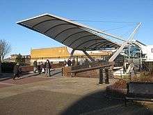
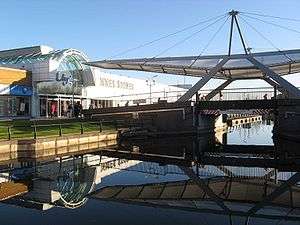 Clyde Shopping Centre incorporates a bridge over the Forth and Clyde Canal. | |
| Population | 26,640 (2012 est.) |
| OS grid reference | NS500700 |
| Lieutenancy area | |
| Country | Scotland |
| Sovereign state | United Kingdom |
| Post town | CLYDEBANK |
| Postcode district | G81 |
| Dialling code | 0141 & 01389 |
| Police | Scottish |
| Fire | Scottish |
| Ambulance | Scottish |
| EU Parliament | Scotland |
| UK Parliament | |
| Scottish Parliament | |

Clydebank is a town in West Dunbartonshire, Scotland. Situated on the north bank of the River Clyde, Clydebank borders Dumbarton and the villages of Old Kilpatrick, Bowling and Milton to the west, as well as the town of Bearsden in East Dunbartonshire, and the Yoker and Drumchapel areas of the adjacent City of Glasgow. Historically part of Dunbartonshire, Clydebank is part of the registration County of Dumbarton, the Dunbartonshire Crown Lieutenancy area, and the wider urban area of Greater Glasgow.[2] Clydebank was founded as a police burgh on 18 November 1886.
History
Early origins
Clydebank (Scottish Gaelic: Bruach Chluaidh) is located within the historical boundaries of the ancient Kingdom of Strathclyde, the Mormaerdom of Lennox, and the parish of Old Kilpatrick (12th century), on the north bank of the River Clyde. A long-standing local legend is that the village of Old Kilpatrick derived its name from being the birthplace of Saint Patrick, the patron saint of Ireland.[3] There do not appear to be any historical sources which support this, however.
The town encompasses part of the Antonine Wall, including, at Hardgate/Duntocher, the site of one of the forts built at regular intervals along the wall. In 2008, the Antonine Wall was designated as a World Heritage Site, as part of a multinational Heritage Site encompassing the borders of the Roman Empire.[4]
Before 1870, the area which later became Clydebank was largely rural, and agricultural. It consisted of some villages (Hardgate, Faifley, Duntocher, Dalmuir, Old Kilpatrick), farms and estates, with some small scale mining operations (coal, limestone and whinstone), several cotton mills and some small boatbuilding yards.[3][5]
Industrial development
At the start of the 1870s, however, the growing trade and industry in Glasgow resulted in the Clyde Navigation Trustees needing additional space for shipping quays in Glasgow. They used their statutory powers to compulsorily purchase the area occupied by the Clyde Bank Iron Shipyard in Govan, which belonged to J & G Thomson. Forced to find another site for their shipyard, J & G Thomson looked at various sites further down the River Clyde, and eventually purchased, from the estates of Miss Hamilton of Cochno, some suitably flat land on the "West Barns o'Clyde" on the north bank of the river, opposite the point where the River Cart flows into the River Clyde. The land was situated close to the Forth and Clyde Canal and to the main road running west out of Glasgow to Dumbarton, and so was conveniently positioned for transporting materials and workers to and from the shipyard. The position opposite the mouth of the River Cart was to also to prove important as the shipyard grew, since it enabled the company to build much bigger, heavier ships than would otherwise have been possible that far up the Clyde. Construction of the new shipyard started on 1 May 1871.[6]
Initially, the company transported workers to and from the shipyard by paddle steamer (passenger steamers were commonly used by people to travel up and down the Clyde well into the second half of the 20th century). However it was not ideal, having to ship workers to and fro all the time, so the company also started building blocks of tenement flats to house the workers. These first blocks of housing became known unofficially as "Tamson's (Thomson's) Buildings", after the name of the company.[6]
Gradually, as the shipyard grew, so did the cluster of buildings grow nearby. More houses, a school, a large shed which served as canteen, community hall and church (known as the "Tarry Kirk"), then finally two proper churches in 1876 and 1877. As the resident population grew, so did the needs and problems associated with a growing population. Other manufacturers and employers moved into the area, and by 1880 approximately 2,000 men were living and working there.[6]
In 1882 a railway line was built running from Glasgow out to the new shipyard (the Glasgow, Yoker and Clydebank Railway). This was followed by the Lanarkshire and Dunbartonshire Railway during the 1890s. Then, between 1882 and 1884, the Singer Manufacturing Company built a massive sewing machine factory in Kilbowie, less than 1⁄2 mile (800 m) north of the Clyde Bank shipyard. More people moved into the area, and finally, in 1886, the local populace petitioned for the creation of a police burgh, on the basis that the area now qualified as a "populous place". The petition was granted, and the new town was named after the shipyard which had given birth to it – Clydebank.[6]
Clydebank blitz
On 13 and 14 March 1941, Luftwaffe bombers attacked various targets in and around Clydebank. In what became known as the Clydebank Blitz, the town was seriously damaged as were the local shipyards, the Dalnottar Royal Navy oil depot[7] and the Singer's Sewing Machine factory.[8][9] Over the two days 528 civilians were killed and over 617 people were seriously injured.[10]
Governance
Clydebank is in West Dunbartonshire, one of the 32 council areas of Scotland. West Dunbartonshire Council, the unitary local authority, is based in Dumbarton and is responsible for local government. For local electoral purposes, West Dunbartonshire is split into wards electing either three or four councillors. The Clydebank Waterfront ward broadly covers the area between the River Clyde and the Forth and Clyde Canal, including the town centre, Whitecrook and part of Dalmuir; it also includes neighbouring Old Kilpatrick. The Clydebank Central ward includes Kilbowie, Linnvale, Radnor Park, Parkhall and the northern part of Dalmuir.
West Dunbartonshire is also divided into community council areas: those covering Clydebank include Dalmuir and Mountblow; Parkhall, North Kilbowie and Central; Linnvale and Drumry; and Clydebank East.
The area that is now Clydebank was once in the territory of the Kingdom of Strathclyde and has been part of the historic county of Dunbartonshire since medieval times. From 1890 onwards, Dunbartonshire was an area of local government administered by a county council. Although Dunbartonshire ceased to be used for local government purposes in 1975, it continues to exist as both a Lieutenancy area and registration county. Clydebank is also within the ancient parish of Old Kilpatrick. The town became a burgh in 1886; as such, it exercised most local government functions independently of the county council.
Following the abolition of administrative counties in 1975, a new Clydebank District was created within Strathclyde Region under the new two tier system of local government. As well as Clydebank itself and its suburbs, the district also covered a wider area including Old Kilpatrick and Bowling. This lasted until the creation of the present unitary authorities in 1996.
Geography
Clydebank is in Scotland's west Central Lowlands, on the north bank of the River Clyde. Part of the Greater Glasgow conurbation, the town is just outside the boundaries of Glasgow itself, 6.5 miles (10.5 km) northwest of the city centre. Although Clydebank is the largest town in the West Dunbartonshire council area, the local authority is based in Dumbarton, which is 7 miles (11 km) to the northwest.
What is now Clydebank was a rural area known as the Barns o' Clyde up until the late 19th century, when the growth of the shipbuilding industry on the river led to the foundation of the village that became Clydebank. As the area rapidly urbanised, Clydebank grew into a town and absorbed older neighbouring settlements such as Dalmuir, Kilbowie and Yoker (although the latter area was largely annexed by Glasgow in 1926).[11]
Areas
The town has lacked any strictly defined administrative boundaries since the abolition of the burgh in 1975. For modern UK Census purposes, the locality of Clydebank is defined as the town centre and surrounding areas, mainly lying south of the A82 road. While this roughly corresponds to the burgh boundaries prior to the Second World War, it excludes outlying areas such as Faifley, Hardgate and Duntocher which were either annexed to the burgh in the postwar era or included in the post-1975 district, and which are often considered to be part of Clydebank.
Areas within the Clydebank census locality include Dalmuir, Linnvale, Mountblow, Radnor Park, Kilbowie and Whitecrook.
The Linnvale housing estate was rebuilt in the late 1940s after being destroyed during the Clydebank Blitz, with its new streets named after members of the Labour government of the time, such as Attlee Avenue and Bevin Avenue. The area has one non-denominational primary school, Linnvale Primary, which also runs a nursery service. Linnvale Parish Church of Scotland was opened under the Church of Scotland's church extension scheme of the 1950s. During the 1980s, Linnvale was one of the areas included in the East End Initiative, and a support team helped to set up groups and clubs and to enable them to become self-sufficient.
Demography
For census purposes, Clydebank is classed as a locality within the settlement of Greater Glasgow. The census definition of Clydebank covers the traditional core area of the town, but excludes outlying areas which have historically been associated with the burgh or district such as Duntocher, Hardgate, Faifley and Old Kilpatrick. According to the United Kingdom Census 2011, Clydebank had a total resident population of 28,799. The population is 93% White Scottish, with white people as a whole making up 98.1% of the total. 63.7% of the population identified as Christian (35.8% Roman Catholic, 25.3% Church of Scotland and 2.6% other Christian denominations), with 28.3% stating they had no religion.[12]
The mid-2012 population estimate suggested the population of Clydebank had decreased to 26,640.[13]
Politics
In the early 20th century the town was synonymous with the Scottish socialist movements led by the shipyard workers along the river Clyde, giving rise to the title of Red Clydeside.
The 11,000 workers at the largest factory of Singer sewing machines went on strike in March–April 1911, ceasing to work in solidarity of 12 female colleagues protesting against work process reorganisation. Following the end of the strike, Singer fired 400 workers, including all strike leaders and purported members of the Industrial Workers of Great Britain, among whom Arthur McManus, who later went on to become the first chairman of the Communist Party of Great Britain between 1920 and 1922.[14]
Labour unrest, in particular by women and unskilled labour, greatly increased between 1910-1914 in Clydeside, with four times more days on strike than between 1900 and 1910. During these four years preceding World War I, membership of those affiliated to the Scottish Trades Union Congress rose from 129,000 in 1909 to 230,000 in 1914.[14]
The town is part of a single urban area (officially the Glasgow City Metropolitan Area) with the terms Glasgow and Greater Glasgow often used interchangeably, with context being important to establish meaning as for some Clydebank residents the claiming of the town as part of the City of Glasgow could be a sensitive issue. This Glasgow City Metropolitan Area includes places falling within the limits of the following local authorities: West Dunbartonshire (Clydebank), all of East Dunbartonshire, North Lanarkshire, South Lanarkshire, Renfrewshire, all of East Renfrewshire and all of the City of Glasgow. These areas form a single health service area, NHS Greater Glasgow and Clyde. Like these areas, most of Clydebank uses the Glasgow telephone area code "0141", however the northern & western portions of the Clydebank area use "01389". The G81 postcode is the most widely used in the area, but the Bowling and Old Kilpatrick areas of the town use G60.
Sport
Clydebank has two semi-professional football teams, Clydebank F.C. and Yoker Athletic F.C.. Both are members of the Scottish Junior Football Association, Clydebank playing in the West of Scotland Superleague Premier Division, two tiers higher than Yoker AFC, who play in the Central District League Division One. Clydebank FC formerly held status as a senior league club but, while in administration in 2002, the club was purchased by a consortium and moved to Airdrie and renamed Airdrie United F.C.. A new Clydebank F.C. were formed in 2003 and entered the Central district of Scottish Junior football. Clydebank also encompasses a variety of amateur football teams including Drumchapel Amateurs who play in Duntocher.
Clydebank's Rugby Football Club is based in Whitecrook. The club was founded on 29 May 1969. Their first game was played at Whitecrook on Monday 1 September 1969 against a Presidents XV captained by Richard Alan of Hutchesons and Scotland. The club play in red and black and regularly field two XVs.
Other sport clubs based in Clydebank are: Singer's Football Club founded in 2013, the Clydesdale Harriers, founded in 1885 as Scotland's first amateur open athletics club; and the Lomond Roads Cycling Club.
The Antonine Sports Centre is located in Duntocher and was established in October 1980. It is a not-for-profit, charitable organisation which is run by a voluntary Board of Directors.
Employment
The town currently has a fairly moderate official unemployment rate of around 6%, however 20% of the population are described by Scottish National Statistics as "employment deprived".[15]
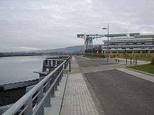
A major employer in the town was its founding firm, the John Brown & Company shipyard, which built several well-known ships, including the RMS Lusitania, Hood, Queen Mary, Queen Elizabeth, and Queen Elizabeth 2. Later it became part of Upper Clyde Shipbuilders, which was the scene of a famous "work-in" in the 1970s. The yard and associated engineering works continued to operate under a succession of owners until it was closed in 2000. The site has been redeveloped, with tourist attractions such as the Titan Clydebank Crane and a new campus for Clydebank College, part of the merged institution West College Scotland.
Singer Corporation was also a major industry in Clydebank, giving thousands of jobs to the townsfolk but closed in 1980, with the Clydebank Business Park later created where its famous building used to stand (next to where Singer railway station is now).
The town is home to the independent Clydebank Co-operative Society which has a number of outlets in the town. The town's main department store closed in 2013
Notable people
- Duncan Bannatyne is a Scottish entrepreneur, philanthropist and author. His business interests include hotels, health clubs, spas, media, TV, stage schools, property and transport.
- Ian McHarg, the influential landscape designer and theorist of regional systems, was born in Clydebank. In his autobiography, he describes walking around its environs; perhaps this led to his views of how nature could be combined with urban development.[16]
- James Cosmo, born in Clydebank 24 May 1948, is a Scottish actor known for his appearances in films such as Highlander, Braveheart, The Chronicles of Narnia: The Lion, the Witch and the Wardrobe, Trainspotting and Troy, and for his appearances in television series such as Game of Thrones. He is the son of actor James Copeland.[17]
- Wet Wet Wet, a famous pop band in the 80s' and 90s', was formed in Clydebank in 1982. The four members of the band met during their education at Clydebank High School, be it in the school bus or in the class. About the poor career perspectives for the youth in Clydebank in the 80s', Graeme Clark, the bass player, said: "It was either crime, the dole, football, or music...and we chose music".[18]
- Kevin Bridges is a stand-up comedian who has toured nationally before sell-out audiences and appeared on a number of television shows, including a programme about his own life where he visited several locations in Clydebank. He was raised in Hardgate.[19]
- Robert Brown was wrongly convicted in 1977 of murdering Annie Walsh in Greater Manchester. Released on appeal in 2002, Brown served 25 years as a miscarriage of justice case in the United Kingdom.[20]
Coat of arms
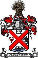
The Burgh of Clydebank adopted an unofficial coat of arms in 1892, when it was required to obtain a common seal by the Burgh Police (Scotland) Act 1892. The design was described disparagingly by Arthur Charles Fox-Davies as a fine healthy specimen of home-made heraldry.[21]
The design comprised a shield surmounted by a mural crown, above which was a helm bearing a wreath and crest. In the centrepiece of the shield was a Lennox Cross representative of the ancient Earls of Lennox. In chief position was a sewing machine representing the Singer Corporation and in base position "on the waves of the sea" was a representation of the battleship HMS Ramillies built at J & G Thomson's Clydebank Shipyard in 1892. In the dexter fess position was a stag's head taken from the coat of arms of shipbuilder James Rodger Thomson, the first Provost of the Burgh. In sinister fess position there was a lion rampant taken from the coat of arms of local landowner, Alexander Dunn Pattison of Dalmuir.
The crest was a garb or wheatsheaf representing the agricultural interests of the area.
The Latin motto below the shield was Labore et Scientia or by work and by knowledge.
In 1929 there was a concerted campaign by the office of Lord Lyon King of Arms to ensure that all burghs using unmatriculated arms regularised their position, and more than fifty burghs registered arms between 1929 and 1931. This led to Clydebank's arms being matriculated on 6 February 1930. The 1930 grant was almost identical to the 1892 device.[22]
In 1975 the burgh was abolished, becoming part of larger Clydebank District, and the burgh arms went out of use. Clydebank District Council was granted new arms on 3 September 1975. This consisted of a red saltire on a white field for the ancient province of Lennox and for the town's more recent historic links to Ireland which previously used the same flag. The cog-wheel symbolised all the local industries and the demi-figure of Saint Patrick referred to Old Kilpatrick, a burgh of barony from 1672, and where the saint is reputed to have been born. A representation of part of the Roman Antonine Wall was included as the Wall and Roman forts at Old Kilpatrick and Greenhill were features common to the burgh and to the villages in the District. The lymphad (galley ship) was for Clyde shipbuilding. The burgh motto was retained.[23] At the request of the district council, the arms were rematriculated on 19 April 1985 with the addition of a dove of peace in the centre of the saltire. The coat of arms went out of use in 1996 with the abolition of the District Council. In 1998 the successor West Dunbartonshire Council was granted very similar arms.[24]
Local transport
The town is served by Abellio ScotRail from Clydebank railway station, Drumry railway station, Dalmuir railway station, Yoker railway station, Kilpatrick railway station and Singer railway station. Bus connections to Glasgow, Dumbarton and the surrounding areas of Clydebank use the bus terminus at the southern end of the Clyde Shopping Centre.
Formerly, the town was connected to the once extensive Glasgow tramway system, being served by routes 9 (via Dumbarton Road) and 1A (via Anniesland). Route 20 served Duntocher. Route 9 (to Dalmuir) was the last service to close. Clydebank held its own 'last tram' day on 6 September 1962, four days after the official end of tramway operation in Glasgow, bringing to an end the operation of the last major tramway system in Great Britain.
References
- ↑ Ainmean-Àite na h-Alba ~ Gaelic Place-names of Scotland
- ↑ "Table KS01: Usual resident population (by locality)" (PDF). 2001 Census: Key Statistics for Settlements and Localities Scotland. General Register Office for Scotland. Archived from the original (PDF) on 25 November 2010. Retrieved 6 February 2010.
- 1 2 Davidson, The Rev. Mr. John (1973–83) [First published 1799]. "Number XV. Old Kilpatrick (County of Dumbarton.)". In Sinclair, Sir John. The Statistical Account of Scotland 1791-1799. Volume 5. Wakefield: E. P. Publishing. pp. 229–240.
- ↑ "(Press release) Antonine Wall Gains World Heritage Site Status". Antonine Wall. 7 July 2008.
- ↑ Barclay, The Rev. Matthew (1845). "Parish of Old Kilpatrick (Presbytery of Dumbarton, Synod of Glasgow and Ayr)". The New Statistical Account of Scotland 1834-1845. Volume 8. Edinburgh: William Blackwood & Sons. pp. 15–35.
- 1 2 3 4 Hood, John (1988). The History of Clydebank. The Parthenon Publishing Group Ltd. pp. 3–5. ISBN 1-85070-147-4.
- ↑ "Dalnottar, Mountblow, Royal Navy Oil Storage Tanks". Canmore. Retrieved 2017-11-18.
- ↑ "Clydebank", Blitz on Clideside. Retrieved 9 June 2011.
- ↑ I.M.M. MacPhail The Clydebank Blitz
- ↑ "Clydebank Blitz" Archived 1 July 2011 at the Wayback Machine., Scotland's History. Retrieved 9 June 2011.
- ↑ Maver, Irene. "No Mean City: 1914 to 1950s: Neighbourhoods". The Glasgow Story. Retrieved 13 September 2017.
- ↑ "Area Profiles". Scotland's Census. National Records of Scotland. Retrieved 12 September 2017.
- ↑ "Estimated population of localities by broad age groups, mid-2012" (PDF). National Records of Scotland. Retrieved 12 September 2017.
- 1 2 The Singer strike 1911, Glasgow Digital Library
- ↑ http://www.sns.gov.uk/Reports/Report.aspx?ReportId=1&PostCode=G81%201BF
- ↑ Lynne Margulis, Brian Hawthorne and James Corner (Eds). 2007. Ian McHarg, Conversations with Students: Dwelling in Nature.New York: Princeton Architectural Press.
- ↑ "James Cosmo Biography (1948–)". Filmreference.com. Retrieved 18 November 2015.
- ↑ End Of Part One; Their Greatest Hits - Wet Wet Wet (Booklet)
- ↑ "Clydebank comedian Kevin Bridges apologises for outburst on stage". Clydebank Post. 26 November 2015. Retrieved 22 March 2017.
- ↑ "Innocent man jailed for 25 years for crime he did not commit calls for justice reform". Herald Scotland. 20 November 2017. Retrieved 24 November 2017.
- ↑ A.C. Fox-Davies, The Book of Public Arms, 2nd edition, London, 1915
- ↑ R. M. Urquhart, Scottish Burgh and County Heraldry, London, 1973
- ↑ R.M. Urquhart, Scottish Civic Heraldry, London, 1979
- ↑ R.M. Urquhart, Scottish Civic Heraldry 2, Hamilton, 2001
Further reading
- I.M.M. MacPhail, The Clydebank Blitz (1974, ISBN 0-85279-061-9)
External links
![]()