Kelvin Aqueduct
| Kelvin Aqueduct | |
|---|---|
| Coordinates | 55°53′33″N 4°18′06″W / 55.8924°N 4.3017°WCoordinates: 55°53′33″N 4°18′06″W / 55.8924°N 4.3017°W |
| Carries | Forth and Clyde Canal |
| Crosses | River Kelvin |
| Characteristics | |
| Material | Stone |
| Longest span | 50 feet (15 m) |
| No. of spans | Four |
| History | |
| Construction end | 1787 |
| Construction cost | GB£8,509 |
| Opened | 1790 |
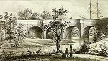
The Kelvin Aqueduct is a navigable aqueduct in Glasgow, Scotland, which carries the Forth and Clyde Canal over the River Kelvin.
History
It was designed by Robert Whitworth, one of John Smeaton's supervising engineers on the Forth and Clyde Canal project.[1] The contractors were William Gibb (founder of the engineering dynasty that led to Sir Alexander Gibb & Partners) and John Muir, who also built the nearby Maryhill locks.[1] A foundation stone was laid on 16 June 1787 by Archibald Spiers, the chairman of the canal committee.[2]
The entire project cost GB£8,509, exceeding the original estimated cost of GB£6,200.[2]
When opened in 1790 was Britain's largest aqueduct,[3] and onlookers were impressed at the sight of sailing boats crossing above them.[4]
It was protected as a category A listed building in 1989.[5]
The structure is in Maryhill, Glasgow.
Design
It is 445 feet (136 m) long, with four arches of 50 feet (15 m) span, and 62 feet (19 m) high above the surface of the river.[3] According to measurements by John Rennie as the canal was nearing completion, there was around 3 feet (0.91 m) of puddle clay at the bottom of the canal.[3] The aqueduct was designed to carry a depth of 8 feet (2.4 m) of water.[6]
The piers are buttressed in such a way as to resemble cutwaters, but only one pier sits in the river.[2] The sides of the aqueduct are arched in order to transfer the outward pressure of the water onto the buttresses, an effect which can clearly be seen from above.[7][8] This design feature is also present on the Luggie Aqueduct at Kirkintilloch, which opened in 1773.[9]
The aqueduct is built from rustic masonry at the lower levels and polished ashlar above.[3] Underneath it is the Kelvin Walkway, which runs through an area of green space around the river.[2][8]
See also
References
- 1 2 "Kelvin Aqueduct". engineering-timelines.com. Archived from the original on 4 March 2016. Retrieved 17 September 2014.
- 1 2 3 4 "Glasgow, Maryhill, Forth and Clyde Canal, Kelvin Aqueduct". rcahms.gov.uk. Retrieved 17 September 2014.
- 1 2 3 4 Arch Bridges and Their Builders 1735-1835. CUP Archive. pp. 128–129. GGKEY:FQ9ZF6QS0H8.
- ↑ Dowds, Thomas J. (2003). The Forth and Clyde Canal: A History. Dundurn. p. 48. ISBN 978-1-86232-232-5.
- ↑ "Forth and Clyde Canal Aqueduct (adjoining Skaethorn Road Bridge): Listed Building Report". Historic Scotland. Retrieved 22 November 2011.
- ↑ Skempton, A. W. (2002). A Biographical Dictionary of Civil Engineers in Great Britain and Ireland: 1500-1830. Thomas Telford. p. 250. ISBN 978-0-7277-2939-2.
- ↑ Paterson, Len (2013). From Sea to Sea: A History of the Scottish Lowland and Highland Canals. Neil Wilson Publishing. p. 49. ISBN 978-1-906000-34-9.
- 1 2 Google (17 September 2014). "Kelvin Aqueduct" (Map). Google Maps. Google. Retrieved 17 September 2014.
- ↑ "Luggie Aqueduct". engineering-timelines.com. Retrieved 17 September 2014.
External links
| Wikimedia Commons has media related to Kelvin Aqueduct. |
Coordinates: 55°53′32″N 4°18′06″W / 55.892352°N 4.301727°W