Dunbar
Dunbar
| |
|---|---|
 Tolbooth and mercat cross, Dunbar High Street | |
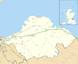 Dunbar  Dunbar Dunbar shown within Scotland | |
| Population | 8,486 [2] (2011 census) |
| OS grid reference | NT678789 |
| Council area | |
| Lieutenancy area | |
| Country | Scotland |
| Sovereign state | United Kingdom |
| Post town | DUNBAR |
| Postcode district | EH42 |
| Dialling code | 01368 |
| Police | Scottish |
| Fire | Scottish |
| Ambulance | Scottish |
| EU Parliament | Scotland |
| UK Parliament | |
| Scottish Parliament | |
Dunbar (/dʌnˈbɑːr/ (![]()
Dunbar is a former royal burgh, and gave its name to an ecclesiastical and civil parish. The parish extends around 7 1⁄2 miles (12.1 km) east to west and is 3 1⁄2 miles (5.6 km) deep at greatest extent, or 11 1⁄4 square miles (29 km2), and contains the villages of West Barns, Belhaven, East Barns (abandoned) and several hamlets and farms.
Its strategic location gave rise to a history full of incident and strife; but Dunbar has become a quiet dormitory town popular with workers in nearby Edinburgh, who find it an affordable alternative to the capital itself. Until the 1960s, the population of the town was little more than 3,500. The town is thriving with the most recent population published for the town at 6,940, and there are many active and planned housing developments ongoing. There are very well regarded primary schools, a secondary school and a private school in the town.
The town is served by Dunbar railway station with links to Edinburgh and the rest of Scotland, as well as London and stations along the north-east corridor.
Dunbar is home to the Dunbar Lifeboat Station, the second-oldest RNLI station in Scotland.
Dunbar is the birthplace of the explorer, naturalist and influential conservationist John Muir. The house in which Muir was born is located on the High Street, and has been converted into a museum. There is also a commemorative statue beside the town clock, and John Muir Country Park is located to the north-west of the town. The eastern section of the John Muir Way coastal path starts from the harbour. One of the two campuses to Dunbar Primary School: John Muir Campus, is named in his honour.
On the last full weekend in September, Dunbar holds an annual weekend-long, traditional music festival sponsored by various local companies.
History
Etymology
In its present form, the name Dunbar is derived from its Gaelic equivalent (modern Scottish Gaelic: Dùn Barra), meaning "summit fort". That itself is probably a Gaelicisation of the Cumbric form din-bar, with the same meaning. This form seems to be attested as Dynbaer the seventh-century Vita Sancti Wilfredi.[3]
Early history
To the north of the present High Street an area of open ground called Castle Park preserves almost exactly the hidden perimeter of an iron age promontory fort. The early settlement was a principal centre of the people known to the Romans as Votadini and it may have grown in importance when the great hillfort of Traprain Law was abandoned at the end of the 5th century AD. Dunbar was subsumed into Anglian Northumbria as that kingdom expanded in the 6th century and is believed to be synonymous with the Dynbaer of Eddius around 680, the first time that it appears in the written record. The influential Northumbrian monk and scholar St. Cuthbert, born around 630, was probably from around Dunbar. While still a boy, and employed as a shepherd, one night he had a vision of the soul of Aidan being carried to heaven by angels and thereupon went to the monastery of Old Melrose and became a monk.
It was then a king's vill and prison to Bishop Wilfrid. As a royal holding of the kings of Northumbria, the economy centred on the collecting of food renders and the administration of the northern (now Scottish) portion of that kingdom. It was the base of a senior royal official, a reeve (later sheriff), and, perhaps, in the 7th century a dynasty of ealdormen or sub-kings who held northern Northumbria against Pictish encroachment.
Scottish conquest
Danish and Norse attacks on southern Northumbria caused its power to falter and the northern portion became equally open to annexation by Scotland. Dunbar was burnt by Kenneth MacAlpin in the 9th century. Scottish control was consolidated in the next century and when Lothian was ceded to Malcolm II after the battle of Carham in 1018, Dunbar was finally an acknowledged part of Scotland.
Throughout these turbulent centuries Dunbar’s status must have been preserved because it next features as part of a major land grant and settlement by Malcolm III in favour of the exiled earl Gospatric of Northumbria (to whom he may have been full cousin) during 1072. Malcolm needed to fill a power vacuum on his south-eastern flank; Gospatric required a base from which to plot the resumption of his Northumbrian holding. The grant included Dunbar and, it can be deduced, an extensive swath of East Lothian and Berwickshire or Merse (hence March). Gospatric founded the family of Dunbar. The head of the House of Dunbar filled the position of Earls of Dunbar and March until the 15th century.
Later history
The town became successively a baronial burgh and royal burgh (1370) and grew slowly under the shadow of the great Castle of the Earls. Scotland and England contended often for control of the castle and the town. The former was "impregnable" and withstood many sieges; the latter was burnt, frequently. The castle had been slighted (deliberately ruined) in 1568 but the town flourished as an agricultural centre and fishing port despite tempestuous times in the seventeenth and early-eighteenth centuries. Major battles were fought nearby in 1296 and 1650. The second Battle of Dunbar (1650) was fought during the Wars of the Three Kingdoms between a Scottish Covenanter army and English Parliamentarians led by Oliver Cromwell. The Scots were routed, leading to the overthrow of the monarchy and the occupation of Scotland.
A permanent military presence was established in the town with the completion of Castle Park Barracks in 1855.[4]
Dunbar gained a reputation as a seaside holiday and golfing resort in the nineteenth century, the "bright and breezy burgh" famous for its "bracing air".
Since 1983, the town has played host to the first outdoor Pipe Band competition of the season in Scotland. The competition, now held at Hallhill Sports Centre on the second Saturday in May, attracts in the region of 70–80 entries from bands across Scotland and over 2,000 visitors for the day. The local band, Dunbar Royal British Legion Pipe Band, has competed with considerable success over the years.
On Saturday 3 January 1987, a devastating fire destroyed much of the town's historic parish church. The church, as it was before the fire, was opened in 1821 and contained a monument to the Earl of Dunbar (1611) which was said to be unequalled throughout Scotland for its Italian craftsmanship in marble. Though the fire practically destroyed the monument and left only the outer walls remaining, the church has since been rebuilt with a modern interior.
Notable residents
- Joan Beaufort, Queen of Scots, wife of King James I of Scotland, who served as the Regent of Scotland in the immediate aftermath of his death and during the minority of her son James II of Scotland, before being engulfed in a power struggle with members of the nobility. In desperation she took refuge in Dunbar Castle where she was subsequently besieged by her opponents, in which place and circumstances she died in the year 1445 [5]
- Alexander Stewart, Duke of Albany, second son of King James II of Scotland and Mary of Guelders, was Duke of Albany, Earl of March, Lord of Annandale and Isle of Man and the Warden of the Marches, which altogether gave him an impressive power base in the east and west borders, centred on Dunbar Castle which he owned and lived in. He attempted to seize control of Scotland from his brother King James III of Scotland, but was ultimately unsuccessful.[6]
- John Stewart, Duke of Albany, de facto ruler of Scotland and important soldier, diplomat and politician in a Scottish and continental European context, was the only son of the above Duke of Albany, and managed where his father had failed and became Regent of Scotland, while he also became Count of Auvergne and Lauraguais in France and, lastly, inherited from his father the position of Earl of March, which allowed him to likewise use Dunbar Castle as his centre of power in Scotland.[7]
- Alexander Dow, influential Orientalist, author and British East India Company army officer and resident and educated in Dunbar for part of his boyhood.
- William Alexander Bain pharmacologist
- Dr James Wyllie Gregor FRSE botanist, born in Dunbar
- Sir Anthony Home, VC KCB, British soldier who was notable as a recipient of the Victoria Cross and the eventual achievement of the rank of Surgeon-General of the British Armed Forces, born and bred in Dunbar from a local family.
- John Muir, important conservationist, geologist, environmental philosopher and pacifist; one of the founders of the United States system of National Parks and Sierra Club
- General Sir Reginald Wingate, 1st Baronet, GCB, GCVO, GBE, KCMG, DSO, TD, army officer and colonial governor, 'the maker of the Anglo-Egyptian Sudan', Governor-General of the Sudan (1899–1916), British High Commissioner in Egypt (1917–1919), commander of military operations in the Hedjaz (1916–1919), for many years the senior general of the British army, long time resident in Dunbar [8]
- Robert Wilson (engineer), one of the inventors of the ship's propeller, born and bred in Dunbar from a local family
- Black Agnes, Countess of Dunbar and heroine of local folklore
- Thomas Boucher, Hilti Rail Specialist for Scotland and the North East
- James Hepburn, 4th Earl of Bothwell, notorious third and last husband of Mary, Queen of Scots, and owner of Dunbar Castle.
- Hugh Trevor-Roper, renowned English historian who boarded at Belhaven Hill School
- Walter Runciman, 1st Baron Runciman, major shipowner and maverick Liberal politician, born in Dunbar to parents from Dunbar [9]
- Saint Wilfrid, 7th to early 8th century English bishop and saint was imprisoned for a time in Dunbar (and so forced to be resident there) [10]
- Saint Cuthbert, early saint and evangelist of the Northumbrian church, Bishop of Lindisfarne,[11] at a time when Northumbria was a leader in promoting and spreading the message of Christianity in a British and wider European context [12] and, he was, according to some authors, born in and initially brought up in Dunbar to a local noble family, before being fostered in the Melrose area with a related or allied family as per the traditions of his class and time [13]
Notable buildings
- Chapel tower (with doocot conversion) of the Trinitarian Priory, Friarscroft, west of the town. Founded c. 1240 by Christiana de Brus, Countess of Dunbar.
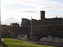
- Dunbar Castle, possibly from the 14th century, rebuilt and remodelled c. 1490 and c. 1520. Largely ruined with the aid of gunpowder (deliberately by Act of Parliament) in 1567 and with the whole north end removed with the aid of explosives (detonated using a specially-invented electrical system) for the new Victoria Harbour 1842–44.
- Parish church (see above) by James Gillespie Graham 1818–21 in local red sandstone from Bourhouse quarry[14]
- Parish Church Hall (1910), located behind the post office off the High Street, contains stained glass removed from St Giles' Cathedral, Edinburgh, redundant there on the creation of the Thistle Chapel.[14]
- Abbey Free Church (1850) by Thomas Hamilton (architect).
- St Anne's Episcopal Church (1889) by Robert Rowand Anderson.
- The Town House (Tolbooth), High Street, (c.1550).
- Mercat Cross (c.1911) created from medieval fragments to replace lost original sited opposite West Port. Now beside Town House.
- Lauderdale House (1790–92), designed by Robert Adam and executed by his brother John after Robert's death; built round the carcass of Dunbar House (c1730).
- Railway station (1845) but altered.
- Cromwell Harbour, very old fishing harbour which dates to 1600s
- Ordance Survey Tidal Gauge - Beneath the Castle Rock at Victoria Harbour is a small castellated building, now the Harbourmaster's office, but originally built in 1913 by the Ordnance Survey and used as part of a network that was used to establish the 'Mean Sea Level' that is used as the reference benchmark for all heights 'above sea level' in the UK.
- Dunbar Battery (1781) was built to protect the town from privateers in the 18th Century and restored in 2017 by Dunbar Harbour Trust with improvements made to access and a new outdoor amphitheatre sensitively inserted within the defensive walls. The Dunbar Battery also features "Sea Cubes", a new public artwork by Scottish artist Donald Urquhart. https://dunbarbattery.org.uk - the project won the Architect's Journal Architecture Awards 2017 for the Best Budget Project of the Year and was Commended in the Scottish Civic Trust My Places Awards 2018.
Archaeology
During 2003, archaeological excavations at Oxwell Mains (Lafarge Cement Works) near Dunbar revealed the site of a Mesolithic house believed to be from around the 9th millennium BC. The site suggests a domed building. Although considered extremely rare and a site of national importance this site is in the middle of an area planned for quarrying.
An archaeological excavation undertaken by Headland Archaeology [15] on a site previously occupied by the Captain's Cabin (a local landmark) within the area of Castle Park identified a sequence of archaeological features reflecting around 2,000 years of human activity. The earliest feature was a large ditch which may have formed part of the defences around a promontory fort previously identified during earlier excavations near the coast at Castle Park.[16] The scale of the ditches indicated an impressive monument. A radiocarbon date of between 50 BC and AD 70 was obtained from charcoal recovered from its infill.
Much later a rectangular building was built over the top of the infilled ditch. Large quantities of burnt grain were recovered indicating that the building was a grain store that had been destroyed by fire. It was established that this was part of the Anglian settlement that had also been identified during earlier excavations.
Between the 9th and 11th centuries the area was used as a cemetery.[17] 76 articulated skeletons and the disarticulated remains of a further 51 individuals were recovered. The articulated skeletons were all buried in the standard Christian fashion. A small number of the skeletons were in long cists but the majority were simple shroud burials.
A dump or midden above the cemetery contained many elephant ivory off-cuts dating to the 18th or 19th centuries.
Climate
As with the rest of Scotland, Dunbar experiences a maritime climate with cool summers and mild winters. The local climate is notable in that it is one of the few places in Scotland to exceed 1,500 hours of sunshine annually. It is also the driest part of Scotland. Recorded temperature extremes range from 31.0 °C (87.8 °F) during August 1990,[18] down to −12.0 °C (10.4 °F) in January 1982.[19]
Environment
Due to its geographical location, Dunbar receives less rain and more hours of direct sunshine per year than anywhere else in Scotland (according to the Met Office). The town has begun to be referred to by locals as 'Sunny Dunny', after a local radio host popularised the term.
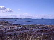
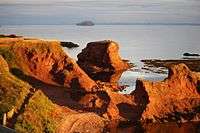
Dunbar has two promenades (forming part of the John Muir Way). These provide an ideal viewpoint to see Dunbar's interesting geological features: including volcanic deposits and dykes; seen from a high vantage point on the western, clifftop promenade, which passes the town's Public and Winterfield parks. Looking down onto a raised shore platform, and the raised beaches, further along the coast, one can get an appreciation of the glacial-isostatic uplift that has occurred in this part of Scotland.
Economy
Dunbar has a thriving local economy with a well-provisioned High Street, as well as many businesses along Spott Road up to the A1 including Howden's, AG Thompson, and Border Roofing [20] among many others.
The town has an Asda supermarket and a filling station (the first in East Lothian). The store is accompanied by a drive-thru McDonald's built in late-2015 (also the first of its kind in East Lothian), a restaurant owned by Marston's named the Pine Marten, a hotel also owned by Marston's and a garden centre.[21][22]
Agriculture remains important, but fishing has declined. Its main manufacturers are cement at Tarmac's Dunbar Cement Plant at Oxwell Mains (the only integrated cement plant in Scotland) and the Scottish Ales of Belhaven Brewery. Another large local employer is Torness Nuclear Power Station.
Twin towns
Dunbar is twinned with Lignières, in France and Martinez, California, United States.
Sport
Football
Dunbar is home to the junior football club Dunbar United.
Dunbar is also home to the Dunbar United Colts Football Club,[23] who play their home matches at Hallhill Sports Centre. The club is open to boys and girls and has around 400 members from 4 years old who play at the Soccer School sessions, right up to adults (Dunbar Athletic) who play in the amateur league. The popular Colts Festival takes place on the second Saturday of Dunbar Civic Week in June of each year. Home colours are black and white stripes. Away colour is blue. Football has been enjoyed by Dunbar youngsters as long ago as the 1920s. During the 1960s the first youth team was formed as Belhaven Boys Club. Training back then took place in the old Belhaven church hall on Beveridge Row. Over the decades training has taken place in a number of locations such as Winterfield and Deer Park. In 1992 the club was renamed Dunbar United Colts Football Club. In September 2001 The Colts moved to their new home at the newly built Hallhill Healthy Living Centre, now known as Hallhill Sports Centre. The Colts are affiliated to the Scottish Youth Football Association and through hard work and dedication are in receipt of the SYFA Community Award. Dunbar United Colts Football Club is run entirely by volunteers.
Golf
Dunbar Golf Club: Laid out in 1857 and redesigned by Old Tom Morris around 1894, Dunbar East Links is situated on the estuary of the Firth of Forth. It is used as an Open Championship Qualifying Venue when the Open is played at Muirfield and all of the major Scottish Championships have been played here, The Scottish Amateur, Scottish Professional Championships, and Scottish Boys’ Championship. The British Ladies and the Ladies Home Internationals have also enjoyed Dunbar as a venue. Dunbar is also home to Winterfield Golf Club.
Rugby
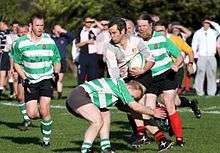
Dunbar is also home to Dunbar RFC. They play their home games at Hallhill Sports Centre and operate a 1st XV, 2nd XV and various school teams. The 1st XV play in the Scottish Hydro Electric National League East 1.
Basketball
Dunbar Grammar School hosts basketball training for many school and club squads. School teams often participate in the Scottish Cup competition for their appropriate level. The school also hosts training for the club Dunbar Dragons.
Education
The town itself is served by two primary schools, West Barns Primary School[24] and Dunbar Primary School,[25] and a non-denominational state secondary school, Dunbar Grammar School.[26] Dunbar Grammar School also serves a wide catchment area which includes the surrounding areas and villages of (East Linton, Stenton and Oldhamstocks). There is also a small number of children who live in Cockburnspath that attend Dunbar Grammar. The school currently has a roll of 713 pupils, and that number is expected to increase with the ongoing expansion of the school and new houses being built in the area. As of August 2018, Claire Slowther, a former deputy head teacher at the school, is the head teacher, succeeding Paul Raffaelli. Dunbar Primary School is split between two campuses, the original building which is now referred to as: "John Muir Campus" taking Primary 1–3s along with nursery pupils, with the newer-built "Lochend Campus"; taking Primary 4–7s.
There is also a private school, Belhaven Hill School, a mixed-sex prep school for 7–13-year-olds.[27]
Youth facilities
Many youth groups use the facilities of The Bleachingfield Community Centre. There is a youth club which runs Mondays, Tuesdays and Thursdays (term time) from 18:30 to 20:00 for primary 4 to 7 children and 20:00 to 22:00 for secondary school-age children. The Youth Cafe is held on Wednesday and Saturday evenings. The centre is also used by a playgroup, an after-school club and a line dancing club.
See also

References
- ↑ Ainmean-Àite na h-Alba ~ Gaelic Place-names of Scotland
- ↑ "Dunbar Locality 2010". Scotland's Census. 2001-04-29. Retrieved 2008-09-02.
- ↑ Bethany Fox, 'The P-Celtic Place-Names of North-East England and South-East Scotland', The Heroic Age, 10 (2007), http://www.heroicage.org/issues/10/fox.html (appendix at http://www.heroicage.org/issues/10/fox-appendix.html).
- ↑ "Historic closes and wynds". Retrieved 6 December 2014.
- ↑ "Joan". www.OxfordDNB.com. Retrieved 19 June 2017.
- ↑
- ↑
- ↑ http://www.oxforddnb.com/view/article/36977?docPos=1
- ↑
- ↑ "Saint Cuthbert and Saint Wilfrid 657-688AD". www.EnglandsNortheast.co.uk. Retrieved 19 June 2017.
- ↑
- ↑ "The Gospels Story - Northumbrian Association". www.NorthumbrianAssociation.com. Retrieved 19 June 2017.
- ↑ Battiscombe, C. F. (ed), The Relics of Saint Cuthbert, Oxford University Press, 1956
- 1 2 Buildings of Scotland:Lothian by Colin McWilliam
- ↑ Moloney, C. (2001). "New evidence for the origins and evolution of Dunbar; excavations at the Captain's Cabin, Castle Park, Dunbar, East Lothian". Proceedings of the Society of Antiquaries of Scotland. 131: 283–318.
- ↑ "Site Record for Dunbar, Castle Park Leisure Pool Development; Dunbar Castle Park; Db87; Db88f; Db03a; Db08Details Details". Rcahms.gov.uk. 1994-04-20. Retrieved 2012-09-09.
- ↑ "Site Record for Dunbar, Castle Park Splash Leisure Pool; Lauderdale House; Dunbar Castle Park; Db09Details Details". Rcahms.gov.uk. 1994-04-20. Retrieved 2012-09-09.
- ↑ "1990 temperature". KNMI.
- ↑ "1982 temperature". KNMI.
- ↑ "Border Roofing - 14 Thorntonloch, Innerwick, Dunbar. EH42 1QT". www.Border-Roofing.co.uk. Retrieved 19 June 2017.
- ↑ Published on Thursday 6 April 2006 09:22 (6 April 2006). "Asda to move into East Lothian - Local Headlines". East Lothian News. Retrieved 9 September 2012.
- ↑ Published on Wednesday 7 November 2007 11:33 (7 November 2007). "New ASDA store seeks local suppliers - Local Headlines". Berwickshire News. Retrieved 9 September 2012.
- ↑ "Homepage - Dunbar United Colts F.C." www.DunbarColts.co.uk. Retrieved 19 June 2017.
- ↑ "West Barns Primary – Together Everyone Achieves More". Edubuzz.org. Retrieved 19 June 2017.
- ↑ "Dunbar Primary School - Standing together. Facing the future". Edubuzz.org. Retrieved 19 June 2017.
- ↑ "Dunbar Grammar School - Non sine pulvere palma". Edubuzz.org. Retrieved 19 June 2017.
- ↑ "Boarding Prep School, East Lothian, Scotland – Belhaven Hill School". www.BelhavenHill.com. Retrieved 19 June 2017.
External links
| Wikimedia Commons has media related to Dunbar. |
| Wikivoyage has a travel guide for Dunbar. |
- Official website
- Video of the Dunbar OS Tide Gauge
- Video footage of the castle and harbour
- East Lothian Council
- eastlothian.gov.uk Eastlothian.gov.uk
| Authority control |
|---|