Lundbreck
| Lundbreck | |
|---|---|
| Hamlet | |
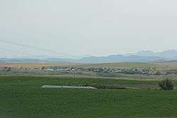 Panorama of Lundbreck from Alberta Highway 22 | |
 Location of Lundbreck in Alberta | |
| Coordinates: 49°35′08″N 114°09′43″W / 49.5856°N 114.1619°WCoordinates: 49°35′08″N 114°09′43″W / 49.5856°N 114.1619°W | |
| Country |
|
| Province |
|
| Census division | No. 3 |
| Municipal district | Municipal District of Pincher Creek No. 9 |
| Government | |
| • Type | Unincorporated |
| • Governing body | Municipal District of Pincher Creek No. 9 Council |
| Area[1] | |
| • Total | 0.42 km2 (0.16 sq mi) |
| Elevation | 1,200 m (3,900 ft) |
| Population (2016)[1] | |
| • Total | 236 |
| • Density | 563.8/km2 (1,460/sq mi) |
| • Dwellings | 141 |
| Time zone | UTC-7 (MST) |
Lundbreck is a hamlet in southern Alberta, Canada within the Municipal District of Pincher Creek No. 9.[2] It is located on the south side of Highway 3, approximately 3 kilometres (1.9 mi) east of the southern terminus of Highway 22, 16 km (9.9 mi) east of the Municipality of Crowsnest Pass, 4 km (2.5 mi) west of the Village of Cowley and 16 km (9.9 mi) west of the Town of Pincher Creek. It has an elevation of 1,200 m (3,900 ft).
It is part of census division No. 3 and the federal riding of Macleod.
History
Lundbreck was incorporated in 1907, celebrated its centennial in 2007, and was named for two coal miners (Lundy and Brecky),.
Lundbreck started out as a coal mining town, that quickly grew to a size of about 1,000 people until the coal mines closed, at which time it quickly shrank.
Demographics
As a designated place in the 2016 Census of Population conducted by Statistics Canada, Lundbreck recorded a population of 236 living in 113 of its 141 total private dwellings, a change of −3.3% from its 2011 population of 244. With a land area of 0.42 km2 (0.16 sq mi), it had a population density of 561.9/km2 (1,455.3/sq mi) in 2016.[3]
As a designated place in the 2011 Census, Lundbreck had a population of 244 living in 111 of its 124 total dwellings, a -12.9% change from its 2006 population of 280. With a land area of 0.35 km2 (0.14 sq mi), it had a population density of 697/km2 (1,806/sq mi) in 2011.[4]
Education
Livingstone School is a K-12, 1A school that was instituted in 1955, as a more modern alternative to the then practice of using several small, one room, multiple grade, rural schools. Kids were bussed in from the local area rural schools from Cowley and the northwest portion of the M.D. of Pincher Creek No. 9.
See also
References
- 1 2
- ↑ Alberta Municipal Affairs (2010-04-01). "Specialized and Rural Municipalities and Their Communities" (PDF). Archived from the original (PDF) on 2012-02-29. Retrieved 2010-07-03.
- ↑ "Population and dwelling counts, for Canada, provinces and territories, and designated places, 2016 and 2011 censuses – 100% data (Alberta)". Statistics Canada. February 8, 2017. Retrieved February 13, 2017.
- ↑ "Population and dwelling counts, for Canada, provinces and territories, and designated places, 2011 and 2006 censuses (Alberta)". Statistics Canada. 2012-02-08. Retrieved 2012-04-07.