Valhalla Centre
| Valhalla Centre | |
|---|---|
| Hamlet | |
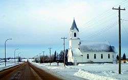 Valhalla Lutheran Church | |
 Location of Valhalla Centre in Alberta | |
| Coordinates: 55°24′13″N 119°22′55″W / 55.4036°N 119.3819°WCoordinates: 55°24′13″N 119°22′55″W / 55.4036°N 119.3819°W | |
| Country |
|
| Province |
|
| Census division | No. 19 |
| Municipal district | County of Grande Prairie No. 1 |
| Government | |
| • Type | Unincorporated |
| • Reeve | Leanne Beaupre |
| • Governing body |
County of Grande Prairie No. 1 Council
|
| Area[1] | |
| • Total | 1.34 km2 (0.52 sq mi) |
| Elevation | 735 m (2,411 ft) |
| Population (2011)[1] | |
| • Total | 45 |
| • Density | 34/km2 (87/sq mi) |
| • Dwellings | 20 |
| Time zone | UTC-7 (MST) |
Valhalla Centre is a hamlet in northern Alberta, Canada within the County of Grande Prairie No. 1.[2]
It is located in the Peace River Country at the junction of Highway 59 and Highway 723, northeast of the Village of Hythe and west of the Town of Sexsmith. It is approximately 40 kilometres (25 mi) east of the British Columbia border and has an elevation of 735 metres (2,411 ft).
The hamlet is located in census division No. 19 and in the federal riding of Peace River.
History
The hamlet was founded in 1912 by Scandinavians that moved north from Edson. It was named by Reverend Halvar N. Ronning after Valhalla, Odin's hall in Norse mythology. The first post office was established in 1916. The settlement grew around a creamery until 1945. The Melsness Mercantile building was built in 1925, and functioned as a store and post office until 1951.[3] Today it hosts a museum dedicated to the Scandinavian heritage of the area, and was declared a Provincial Historic Site.
Demographics
As a designated place in the 2016 Census of Population conducted by Statistics Canada, Valhalla Centre recorded a population of 15 living in 9 of its 9 total private dwellings, a change of −66.7% from its 2011 population of 45. With a land area of 1.22 km2 (0.47 sq mi), it had a population density of 12.3/km2 (31.8/sq mi) in 2016.[4]
As a designated place in the 2011 Census, Valhalla Centre had a population of 45 living in 19 of its 20 total dwellings, a -25% change from its 2006 population of 60. With a land area of 1.34 km2 (0.52 sq mi), it had a population density of 33.6/km2 (87.0/sq mi) in 2011.[1]
The population of Valhalla Centre according to the County of Grande Prairie No. 1's 2006 municipal census is 48.[5]
Economy
The economy is centred on farming and stock raising.
Amenities
The hamlet has a church (Valhalla Lutheran Church), curling rink, skating rink, museum and K-8 school (Valhalla Community School). The school is one of 13 publicly funded Alberta Chartered Schools.
See also
References
- 1 2 3 "Population and dwelling counts, for Canada, provinces and territories, and designated places, 2011 and 2006 censuses (Alberta)". Statistics Canada. 2012-02-08. Retrieved 2012-04-07.
- ↑ Alberta Municipal Affairs (2010-04-01). "Specialized and Rural Municipalities and Their Communities" (PDF). Retrieved 2010-06-24.
- ↑ Discover the Peace Country. "Valhalla Centre". Retrieved 2008-02-14.
- ↑ "Population and dwelling counts, for Canada, provinces and territories, and designated places, 2016 and 2011 censuses – 100% data (Alberta)". Statistics Canada. February 8, 2017. Retrieved February 13, 2017.
- ↑ County of Grande Prairie No. 1. "Economic Profile" (PDF). Retrieved January 10, 2010.
External links
Places adjacent to Valhalla Centre | ||||||||||
|---|---|---|---|---|---|---|---|---|---|---|
| ||||||||||